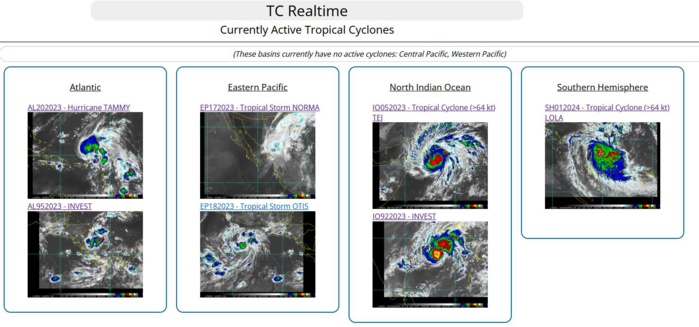
CLICK ON THE IMAGERIES BELOW TO GET THEM ENLARGED
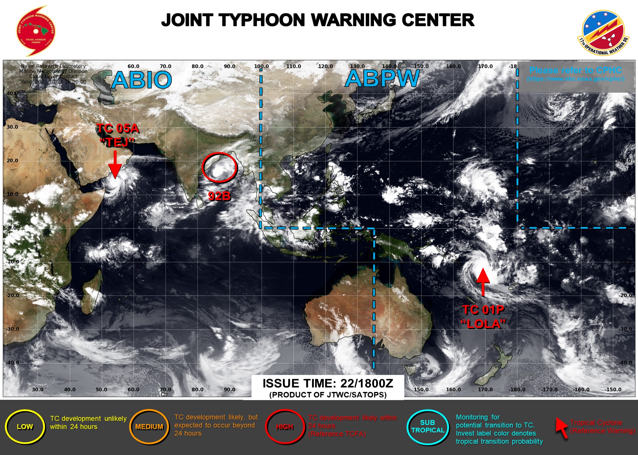
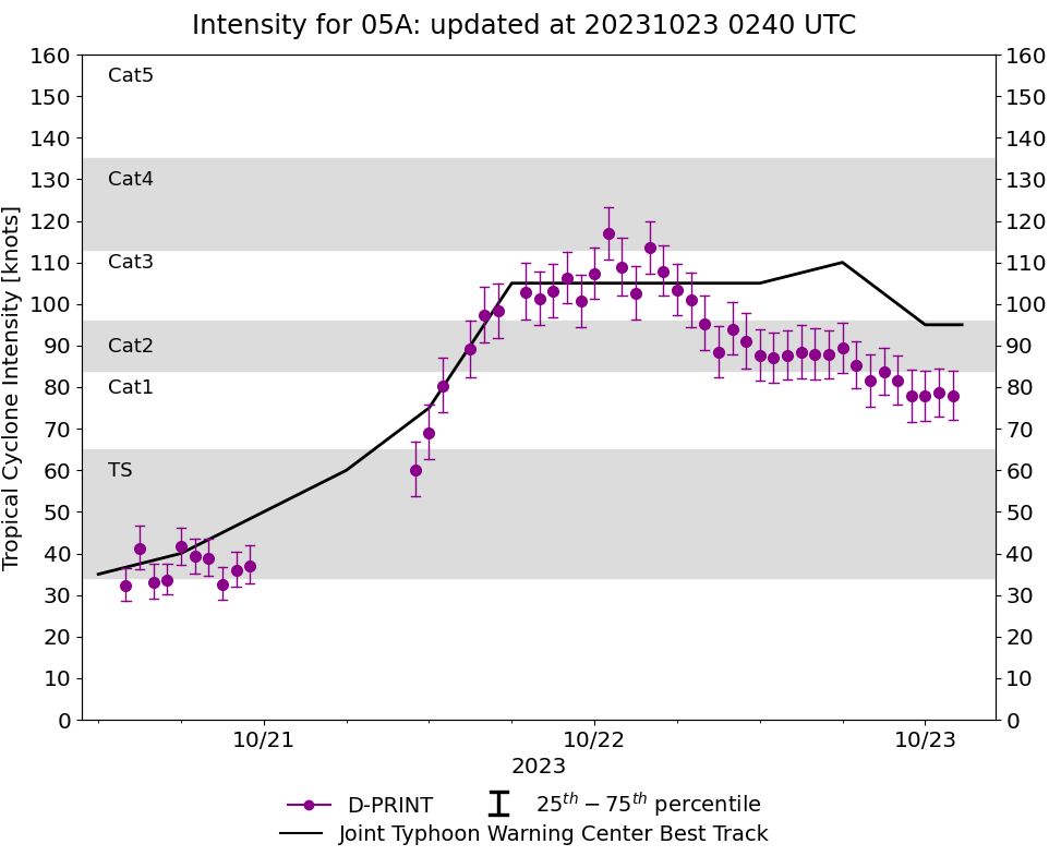
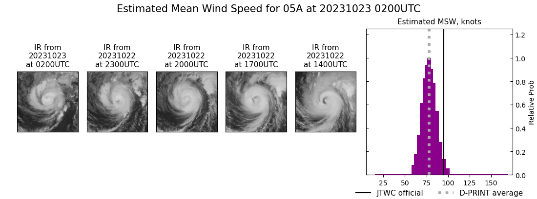
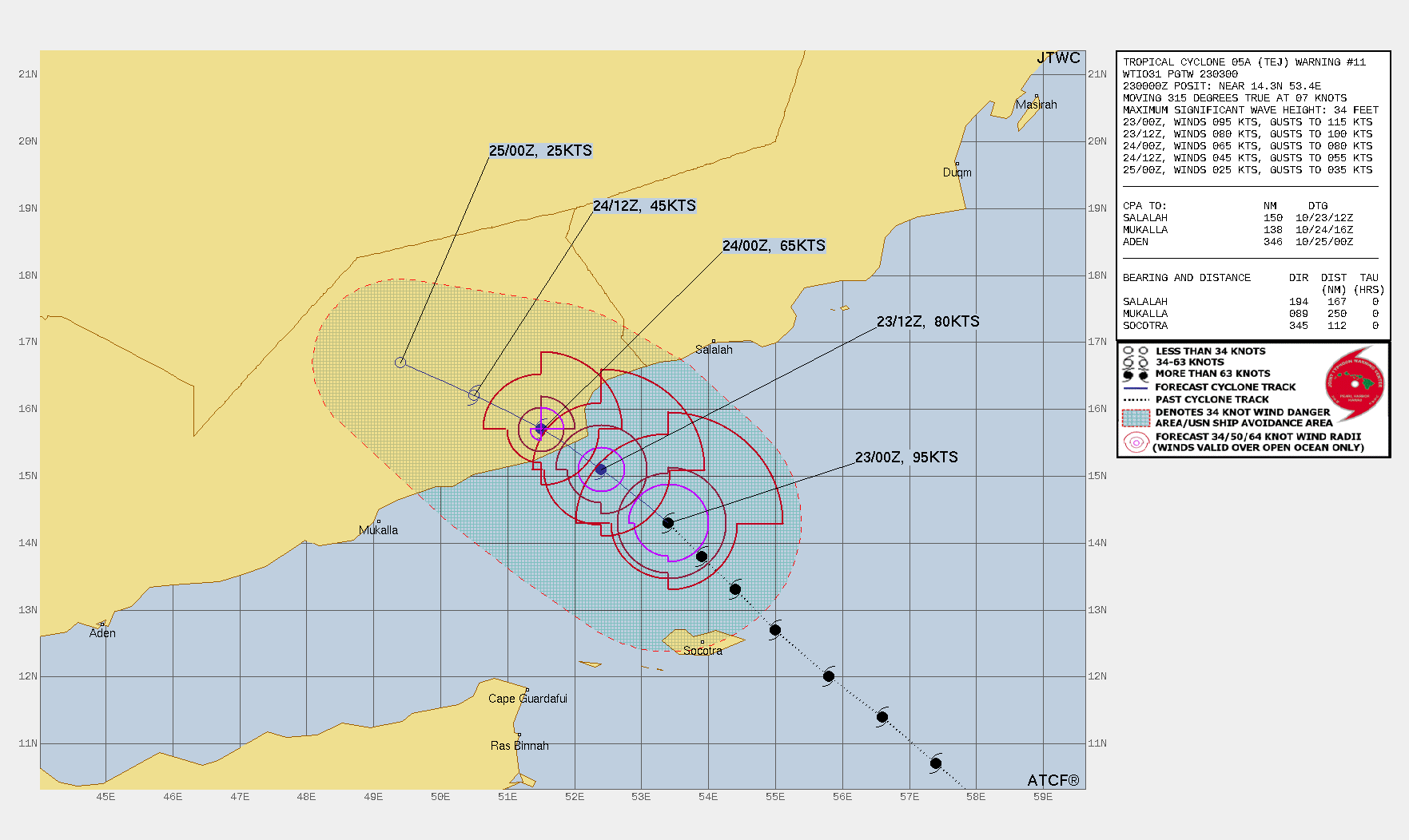
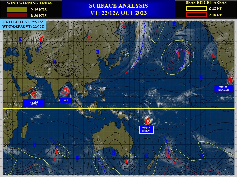
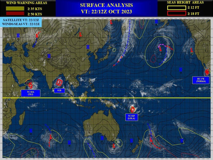
NORTH INDIAN/ARABIAN SEA: TC 05A(TEJ). CURRENT ESTIMATED INTENSITY IS 95 KNOTS/ CAT 2 US: -10 KNOTS/24H.
0523101706 120N 690E 15
0523101712 117N 682E 15
0523101718 116N 675E 15
0523101800 115N 671E 20
0523101806 115N 666E 20
0523101812 108N 658E 20
0523101818 103N 649E 15
0523101900 100N 640E 15
0523101906 99N 632E 15
0523101912 97N 625E 20
0523101918 95N 620E 20
0523102000 93N 618E 30
0523102006 93N 616E 30
0523102012 93N 607E 35
0523102018 96N 599E 40
0523102100 98N 592E 50
0523102106 101N 581E 60
0523102112 107N 574E 75
0523102118 114N 566E 105
0523102200 120N 558E 105
0523102206 127N 550E 105
0523102212 133N 544E 105
0523102218 138N 539E 110
0523102300 143N 534E 95
NNNN
WARNING 11 ISSUED AT 23/03UTC.
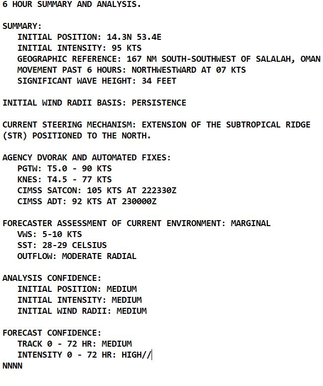
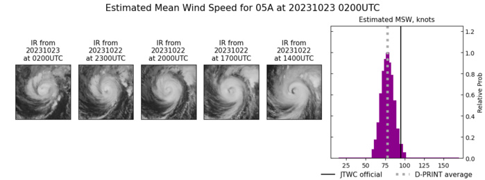
SATELLITE ANALYSIS, INITIAL POSITION AND INTENSITY DISCUSSION: ANIMATED ENHANCED INFRARED (EIR) SATELLITE IMAGERY DEPICTS A RAPIDLY WEAKENING CORE WITH DRY AIR ENTRAINMENT ERODING CONVECTION OVER THE SOUTHERN SEMICIRCLE. A 222237Z ATMS 88.2 GHZ MICROWAVE IMAGE REVEALS DEEP CONVECTIVE BANDING WRAPPING AROUND THE NORTHERN AND WESTERN QUADRANTS INTO AN ELONGATED LOW-LEVEL CIRCULATION CENTER, WITH THE BULK OF THE DEEP CONVECTION OVER THE NORTHERN SEMICIRCLE. THE INITIAL POSITION IS PLACED WITH MEDIUM CONFIDENCE BASED ON THE ATMS IMAGE. THE INITIAL INTENSITY OF 95 KTS IS ASSESSED WITH MEDIUM CONFIDENCE BASED ON THE PGTW CURRENT INTENSITY ESTIMATE OF 5.0 (90 KNOTS) AND A RECENT AIDT ESTIMATE OF 93 KNOTS.
TC Warning Graphic
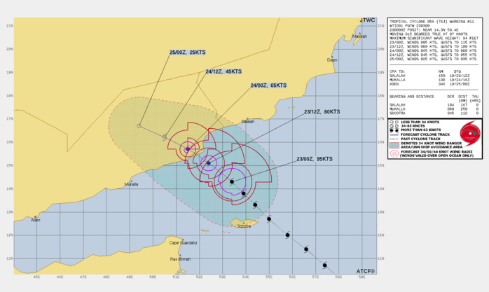
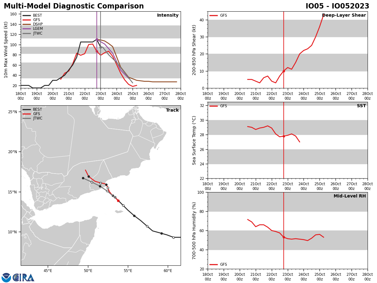
FORECAST REASONING. SIGNIFICANT FORECAST CHANGES: THERE ARE NO SIGNIFICANT CHANGES TO THE FORECAST FROM THE PREVIOUS WARNING. FORECAST DISCUSSION: TC 05A IS FORECAST TO TRACK NORTHWESTWARD TO WEST-NORTHWESTWARD ALONG THE SOUTHERN PERIPHERY OF THE STR THROUGH THE FORECAST PERIOD. LANDFALL WILL OCCUR NEAR TAU 18 BUT THE SYSTEM SHOULD WEAKEN RAPIDLY AFTER TAU 12 DUE TO SIGNIFICANT DRY AIR ENTRAINMENT FROM THE ARABIAN PENINSULA AND INTERACTION WITH LAND. THE HAFS-A MESOSCALE MODEL CONTINUES TO INDICATE STRONG CONVECTION AND HEAVY RAINFALL PERSISTING OVER THE NORTHERN SEMICIRCLE AT LANDFALL AND INLAND.
Model Diagnostic Plot
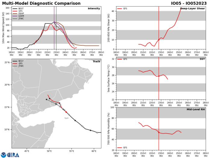
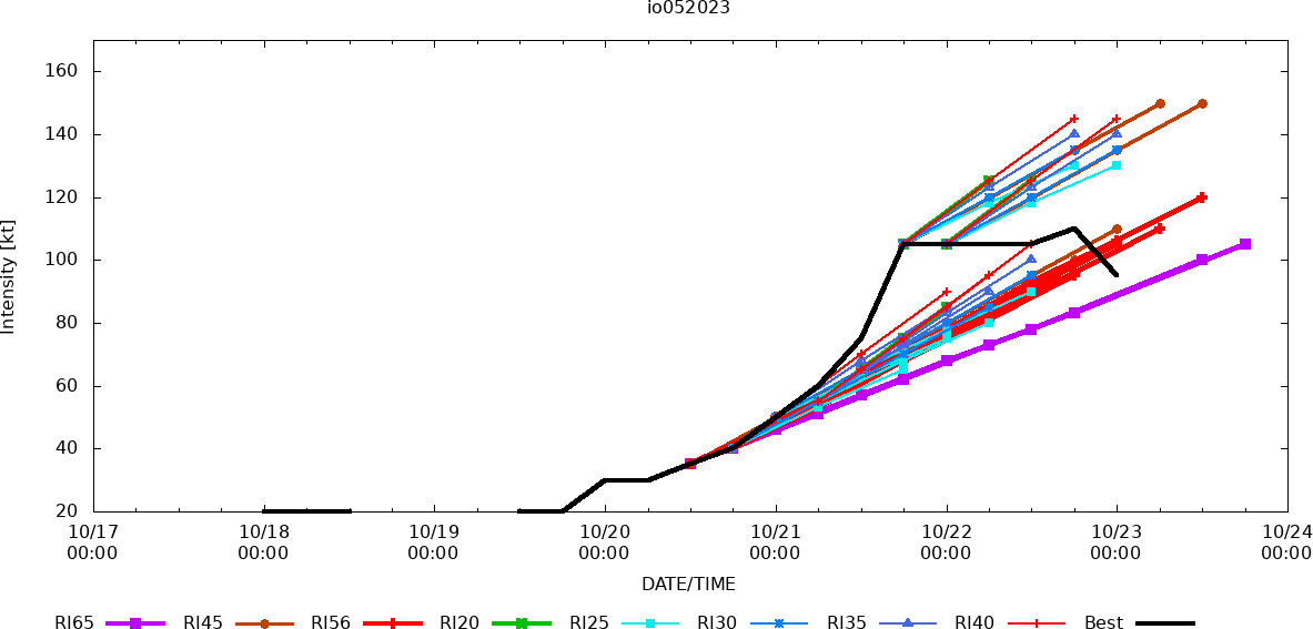
MODEL DISCUSSION: WITH THE EXCEPTION OF THE GALWEM (AFUM) TRACKER AND UKMET ENSEMBLE MEAN (UEMN) TRACKER, WHICH TRACK THE REMNANT SYSTEM INTO THE GULF OF ADEN, THE BULK OF THE GUIDANCE IS IN FAIR AGREEMENT SUPPORTING THE JTWC TRACK FORECAST WITH MEDIUM CONFIDENCE. RELIABLE INTENSITY GUIDANCE IS IN TIGHT AGREEMENT WITH THE RAPID WEAKENING FORECAST AFTER TAU 12.
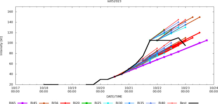
RIPA Forecast
RCM-2, STAR Synthetic Aperture Radar 3KM Wind Speed Analysis 2023 10 22 1424UTC MAXIMUM 1MN WINDS: 116 KNOTS
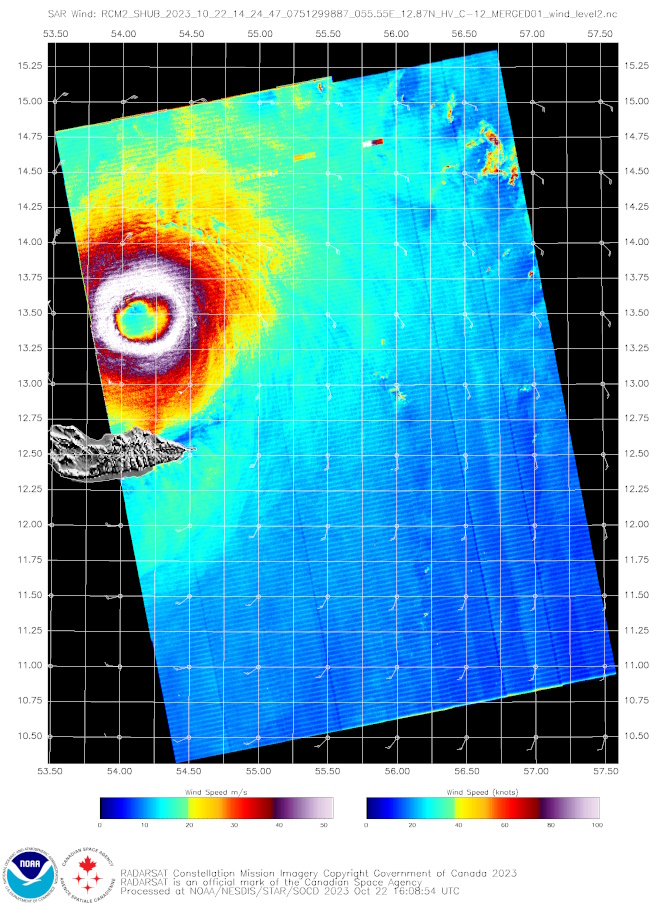
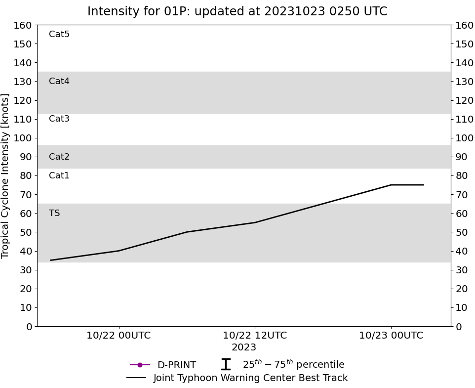
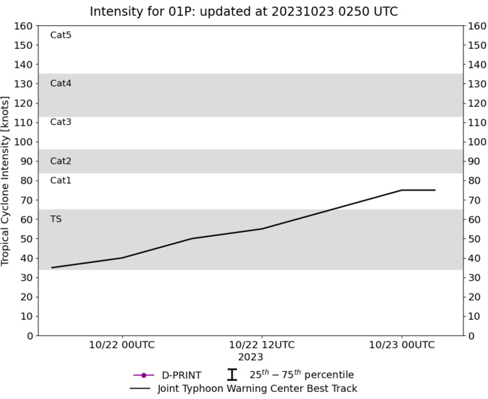
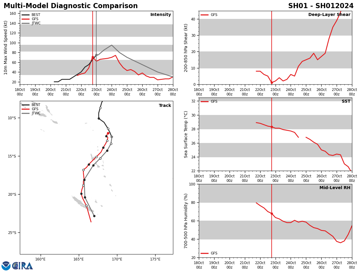
SOUTH PACIFIC OCEAN: TC 01P(LOLA). CURRENT ESTIMATED INTENSITY IS 75 KNOTS/ CAT 1 US: +35 KNOTS/24H.
0123102006 55S1693E 20
0123102012 62S1691E 20
0123102018 68S1688E 25
0123102100 73S1684E 25
0123102106 80S1680E 25
0123102112 87S1678E 30
0123102118 94S1676E 35
0123102200 101S1676E 40
0123102206 106S1683E 50
0123102212 114S1688E 55
0123102218 120S1691E 65
0123102300 125S1693E 75
0123102012 62S1691E 20
0123102018 68S1688E 25
0123102100 73S1684E 25
0123102106 80S1680E 25
0123102112 87S1678E 30
0123102118 94S1676E 35
0123102200 101S1676E 40
0123102206 106S1683E 50
0123102212 114S1688E 55
0123102218 120S1691E 65
0123102300 125S1693E 75
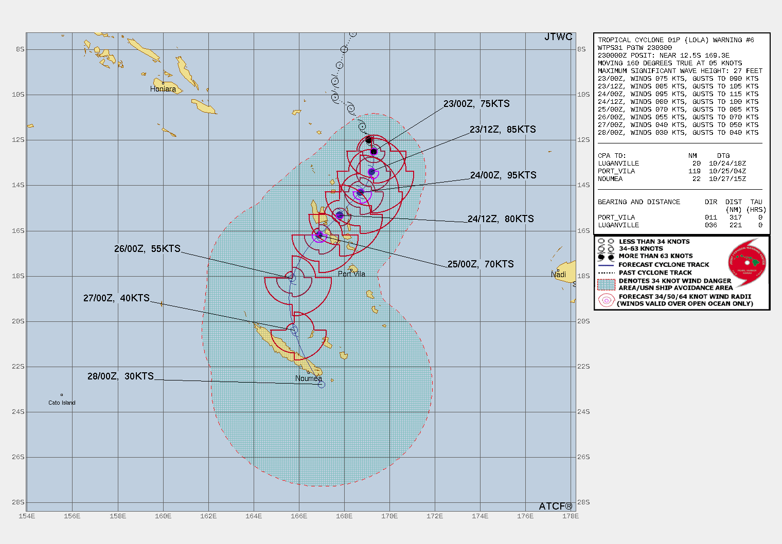
WARNING 6 ISSUED AT 23/03UTC.
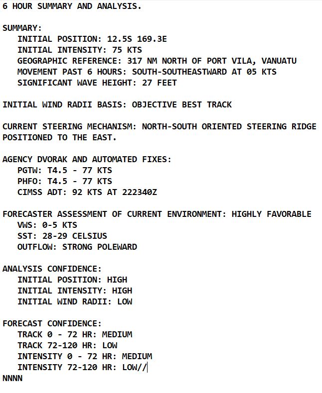
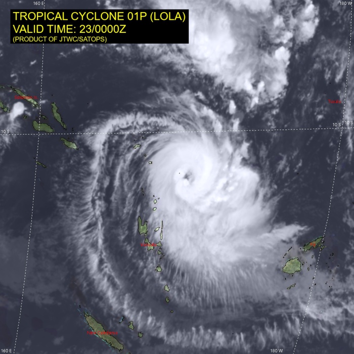
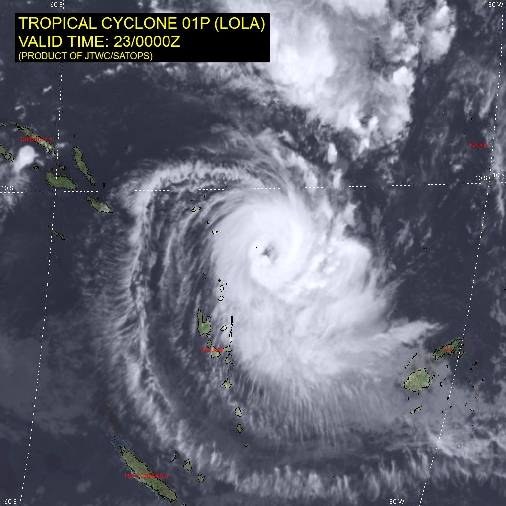
SATELLITE ANALYSIS, INITIAL POSITION AND INTENSITY DISCUSSION: TROPICAL CYCLONE (TC) 01P HAS RAPIDLY INTENSIFIED 35 KNOTS OVER THE PAST 24 HOURS FROM 40 KNOTS AT 220000Z TO THE CURRENT INTENSITY OF 75 KNOTS. ANIMATED ENHANCED INFRARED (EIR) SATELLITE IMAGERY DEPICTS TIGHTLY CURVED BANDING WRAPPING INTO A 30 NM DIAMETER RAGGED EYE, WHICH SUPPORTS THE INITIAL POSITION WITH HIGH CONFIDENCE. THE INITIAL INTENSITY OF 75 KTS IS ASSESSED WITH HIGH CONFIDENCE BASED ON THE PGTW, PHFO SUBJECTIVE DVORAK ESTIMATES.
TC Warning Graphic
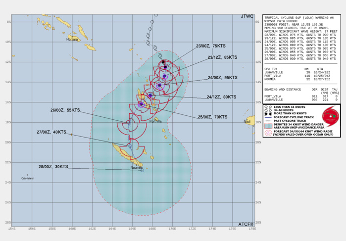
FORECAST REASONING. SIGNIFICANT FORECAST CHANGES: THERE ARE NO SIGNIFICANT CHANGES TO THE FORECAST FROM THE PREVIOUS WARNING. FORECAST DISCUSSION: TC 01P IS FORECAST TO TURN SOUTH-SOUTHWESTWARD ALONG AN EXTENSION OF THE SUBTROPICAL RIDGE (STR) POSITIONED TO THE SOUTHEAST AND EXPECTED TO TRACK SOUTH-SOUTHWESTWARD TO SOUTHWESTWARD THROUGH TAU 48. ENVIRONMENTAL CONDITIONS WILL REMAIN HIGHLY FAVORABLE UNTIL ABOUT TAU 24 WITH A PEAK INTENSITY OF 95-100 KNOTS WITHIN THE NEXT DAY. GRADUAL WEAKENING IS ANTICIPATED AFTER TAU 24 DUE TO LAND INTERACTION WITH MORE SIGNIFICANT WEAKENING AFTER TAU 48 DUE TO INCREASING VERTICAL WIND SHEAR (15 TO 20 KNOTS) AND COOLING SST (26- 27 C). THE SYSTEM SHOULD TRACK JUST SOUTH OF ESPIRITU SANTO, VANUATU THEN RECURVE GRADUALLY SOUTH-SOUTHEASTWARD TOWARD NEW CALEDONIA WHILE RAPIDLY WEAKENING DUE TO STRONG VERTICAL WIND SHEAR (25 TO 40 KNOTS) ASSOCIATED WITH THE SUBTROPICAL WESTERLIES AND COOL SST (25 TO 40 KNOTS TO 24 C). TC 01P WILL LIKELY DISSIPATE NEAR TAU 120 AS IT INTERACTS WITH A WEAK BAROCLINIC ZONE AND HOSTILE ENVIRONMENTAL CONDITIONS (VWS GREATER THAN 50 KNOTS AND SST COOLER THAN 22 C).
Model Diagnostic Plot
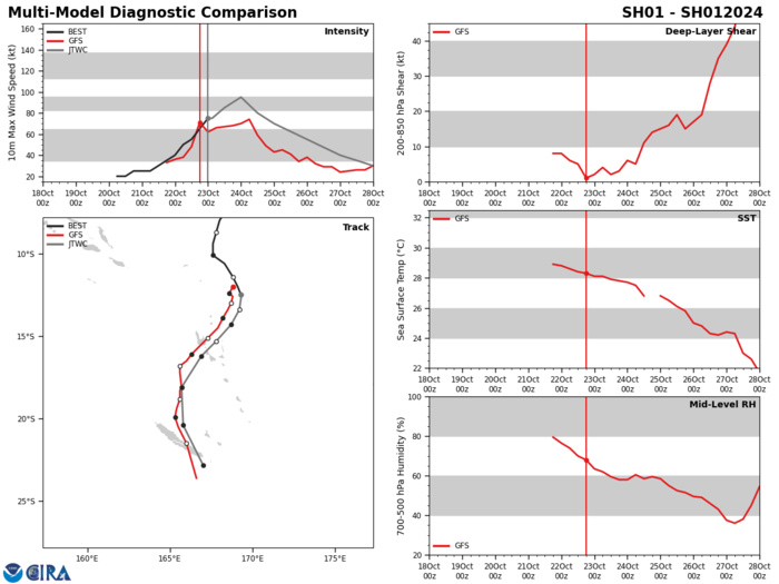
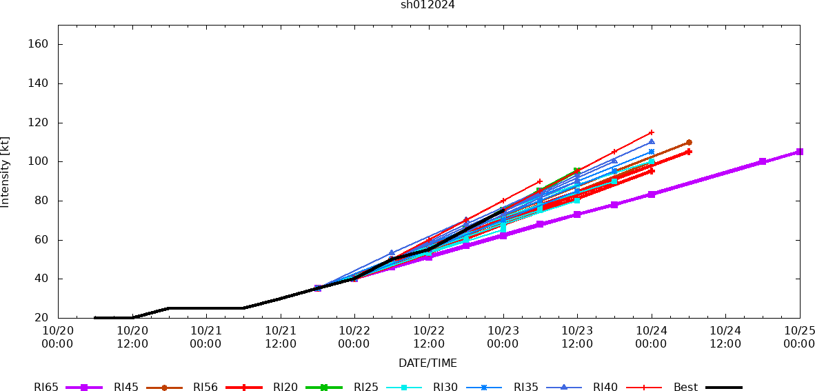
MODEL DISCUSSION: NUMERICAL MODEL GUIDANCE HAS COME INTO BETTER ALIGNMENT OVER THE PAST DAY BUT STILL REFLECTS UNCERTAINTY IN THE EXACT TRACK, ESPECIALLY IN RESPECT TO THE ISLANDS OF VANUATU AND NEW CALEDONIA. THERE IS A 100 NM CROSS-TRACK SPREAD AT TAU 36 WITH SOLUTIONS FROM NORTHERN ESPIRITU SANTO ISLAND TO MALEKULA ISLAND. THE BETTER GUIDANCE (ECMWF, GFS) SHOW A TRACK SOUTH OF ESPIRITU SANTO WITH THE BULK OF THE 221800Z ECMWF ENSEMBLE (EPS) SOLUTIONS ALSO FAVORING THE SOUTH OF ESPIRITU SANTO TRACK. THE 221800Z GFS ENSEMBLE (GEFS) IS MORE EVENLY SPREAD ACROSS BOTH ISLANDS. THERE IS NOW A LOW PROBABILITY FOR CONTINUED RAPID INTENSIFICATION WITH THE 221800Z COAMPS-TC ENSEMBLE (GFS VERSION) INDICATING A LOW (20 PERCENT) PROBABILITY FOR RI THROUGH TAU 24. HOWEVER, THE COAMPS-TC ENSEMBLE INDICATES 80 TO 90 PERCENT PROBABILITIES FOR MODERATE INTENSIFICATION THROUGH TAU 24.
RIPA Forecast
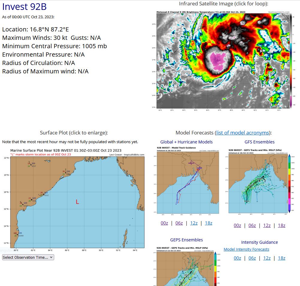
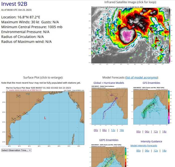
NORTH INDIAN/BAY OF BENGAL: INVEST 92B. ESTIMATED LOCATION AND INTENSITY AT 23/00UTC.
9223102018 127N 883E 20
9223102100 131N 878E 20
9223102106 136N 874E 20
9223102112 140N 871E 25
9223102118 144N 866E 25
9223102200 149N 865E 30
9223102206 153N 866E 30
9223102212 157N 867E 30
9223102218 161N 869E 30
9223102300 168N 872E 30
9223102100 131N 878E 20
9223102106 136N 874E 20
9223102112 140N 871E 25
9223102118 144N 866E 25
9223102200 149N 865E 30
9223102206 153N 866E 30
9223102212 157N 867E 30
9223102218 161N 869E 30
9223102300 168N 872E 30
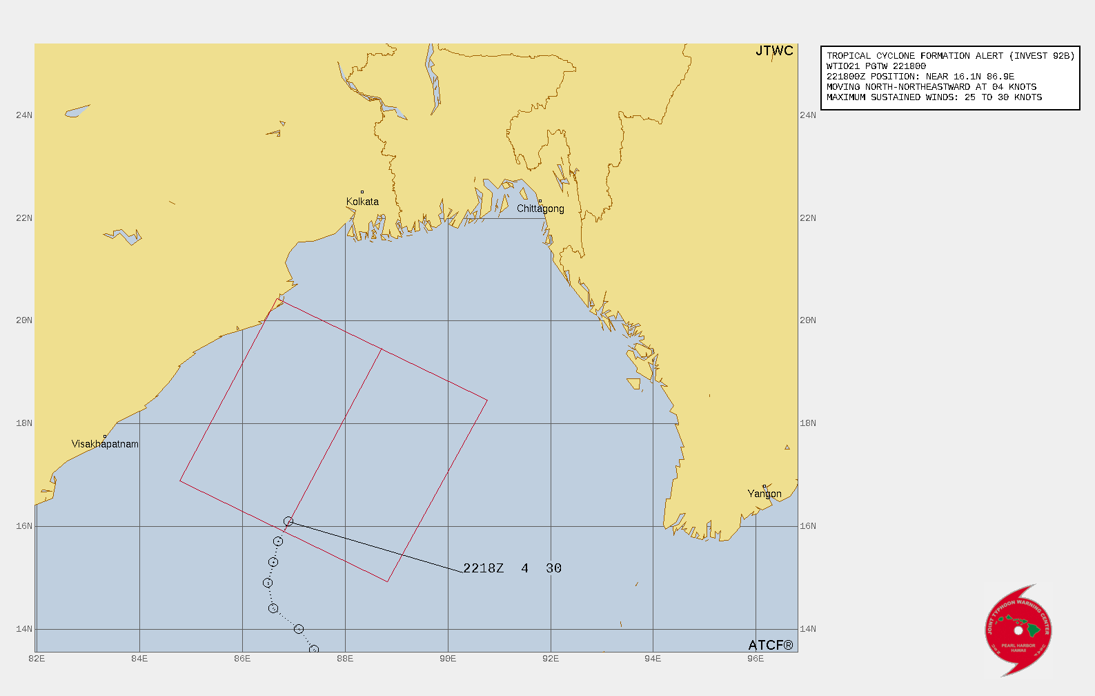
TROPICAL CYCLONE FORMATION ALERT ISSUED AT 22/18UTC.
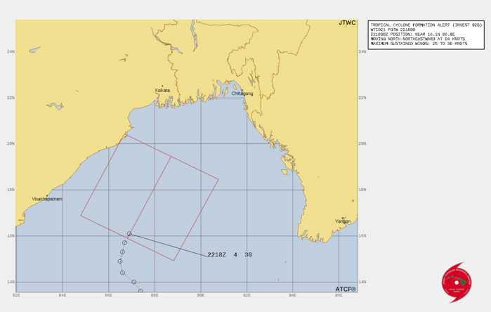
WTIO21 PGTW 221800 MSGID/GENADMIN/JOINT TYPHOON WRNCEN PEARL HARBOR HI// SUBJ/TROPICAL CYCLONE FORMATION ALERT (INVEST 92B)// RMKS/ 1. FORMATION OF A SIGNIFICANT TROPICAL CYCLONE IS POSSIBLE WITHIN 130 NM EITHER SIDE OF A LINE FROM 15.9N 86.8E TO 19.5N 88.7E WITHIN THE NEXT 12 TO 24 HOURS. AVAILABLE DATA DOES NOT JUSTIFY ISSUANCE OF NUMBERED TROPICAL CYCLONE WARNINGS AT THIS TIME. WINDS IN THE AREA ARE ESTIMATED TO BE 25 TO 30 KNOTS. METSAT IMAGERY AT 221730Z INDICATES THAT A CIRCULATION CENTER IS LOCATED NEAR 16.1N 86.9E. THE SYSTEM IS MOVING NORTH-NORTHEASTWARD AT 04 KNOTS. 2. REMARKS: THE AREA OF CONVECTION (INVEST 92B) PREVIOUSLY LOCATED NEAR 14.1N 87.3E IS NOW LOCATED NEAR 16.1N 86.9E, APPROXIMATELY 393 NM SOUTH OF KOLKATA, INDIA. ANIMATED ENHANCED INFRARED (EIR) SATELLITE IMAGERY DEPICTS PERSISTENT DEEP CONVECTION OVER THE NORTHERN SEMICIRCLE WRAPPING INTO THE WESTERN QUADRANT OF A PARTIALLY EXPOSED LOW-LEVEL CIRCULATION (LLC). A 221506Z MHS 89 GHZ MICROWAVE IMAGE REVEALS A CURVED DEEP CONVECTIVE BAND OVER THE NORTHERN AND WESTERN QUADRANTS WITH WEAKER, SHALLOW BANDING ELSEWHERE. A 221510Z ASCAT-B IMAGE SHOWS A DEFINED CIRCULATION WITH 25 TO 30 KNOT WINDS OVER THE NORTHERN SEMICIRCLE AND WEAKER 15 TO 25 KNOT WINDS OVER THE SOUTHERN SEMICIRCLE. ENVIRONMENTAL CONDITIONS ARE FAVORABLE WITH LOW (10 TO 15 KNOTS) VERTICAL WIND SHEAR, GOOD POLEWARD OUTFLOW, AND WARM SEA SURFACE TEMPERATURES (29-30 C). GLOBAL MODELS INDICATE A NORTH- NORTHEASTWARD TRACK TOWARD BANGLADESH WITH GRADUAL DEVELOPMENT OVER THE NEXT TWO DAYS. MAXIMUM SUSTAINED SURFACE WINDS ARE ESTIMATED AT 25 TO 30 KNOTS. MINIMUM SEA LEVEL PRESSURE IS ESTIMATED TO BE NEAR 1005 MB. THE POTENTIAL FOR THE DEVELOPMENT OF A SIGNIFICANT TROPICAL CYCLONE WITHIN THE NEXT 24 HOURS IS HIGH.
Model Diagnostic Plot
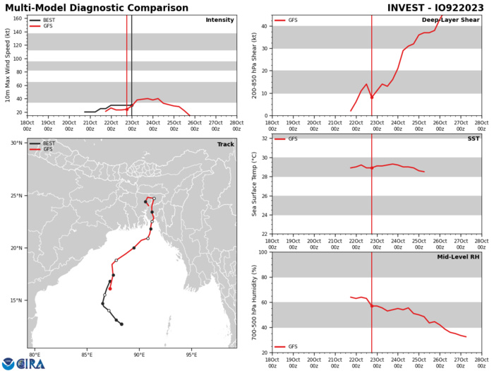
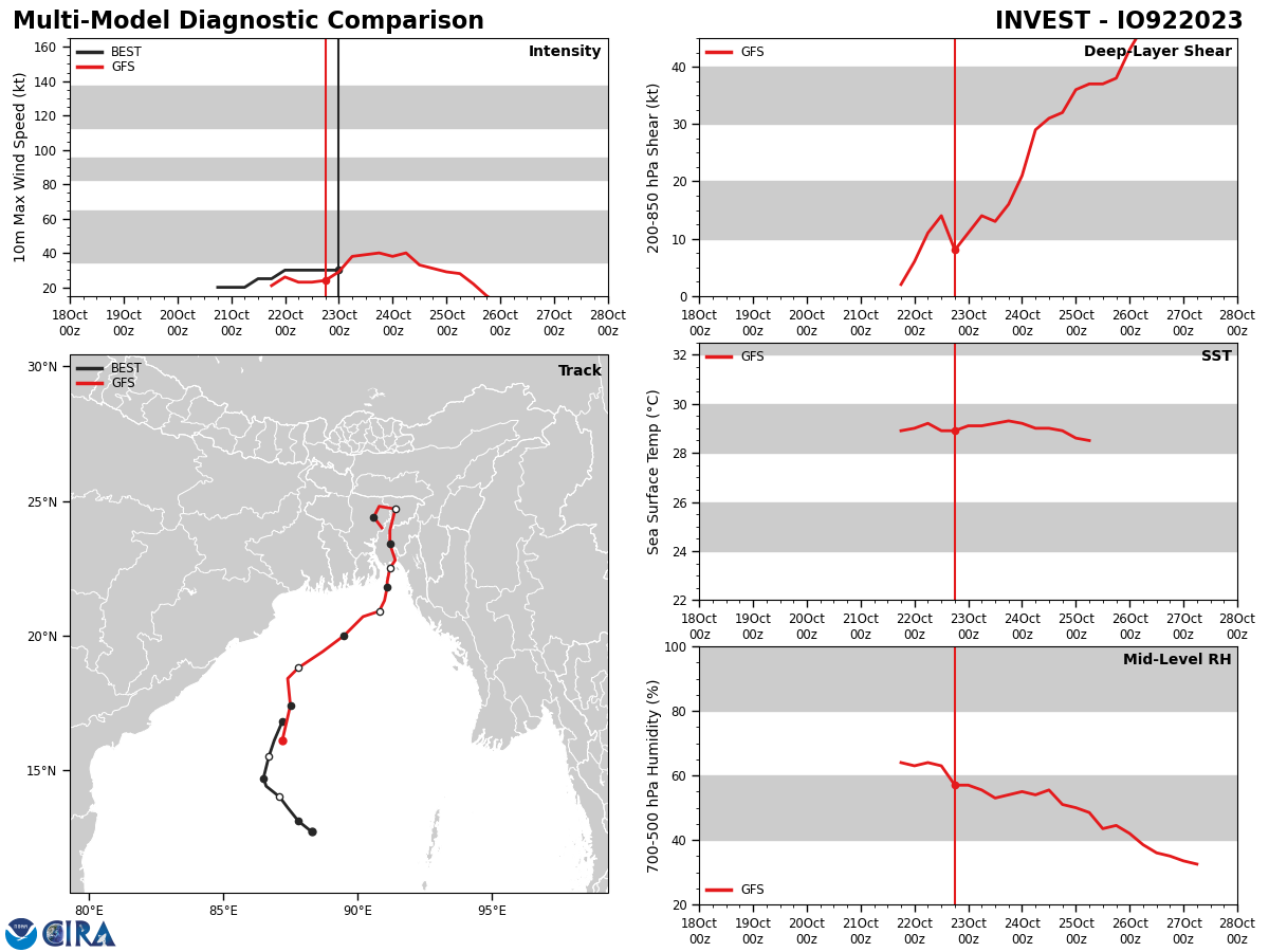
GLOBAL MODELS INDICATE A NORTH- NORTHEASTWARD TRACK TOWARD BANGLADESH WITH GRADUAL DEVELOPMENT OVER THE NEXT TWO DAYS.
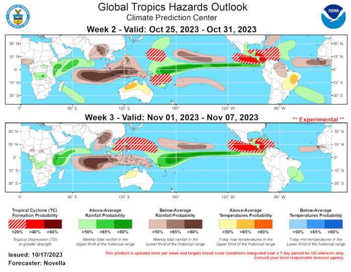
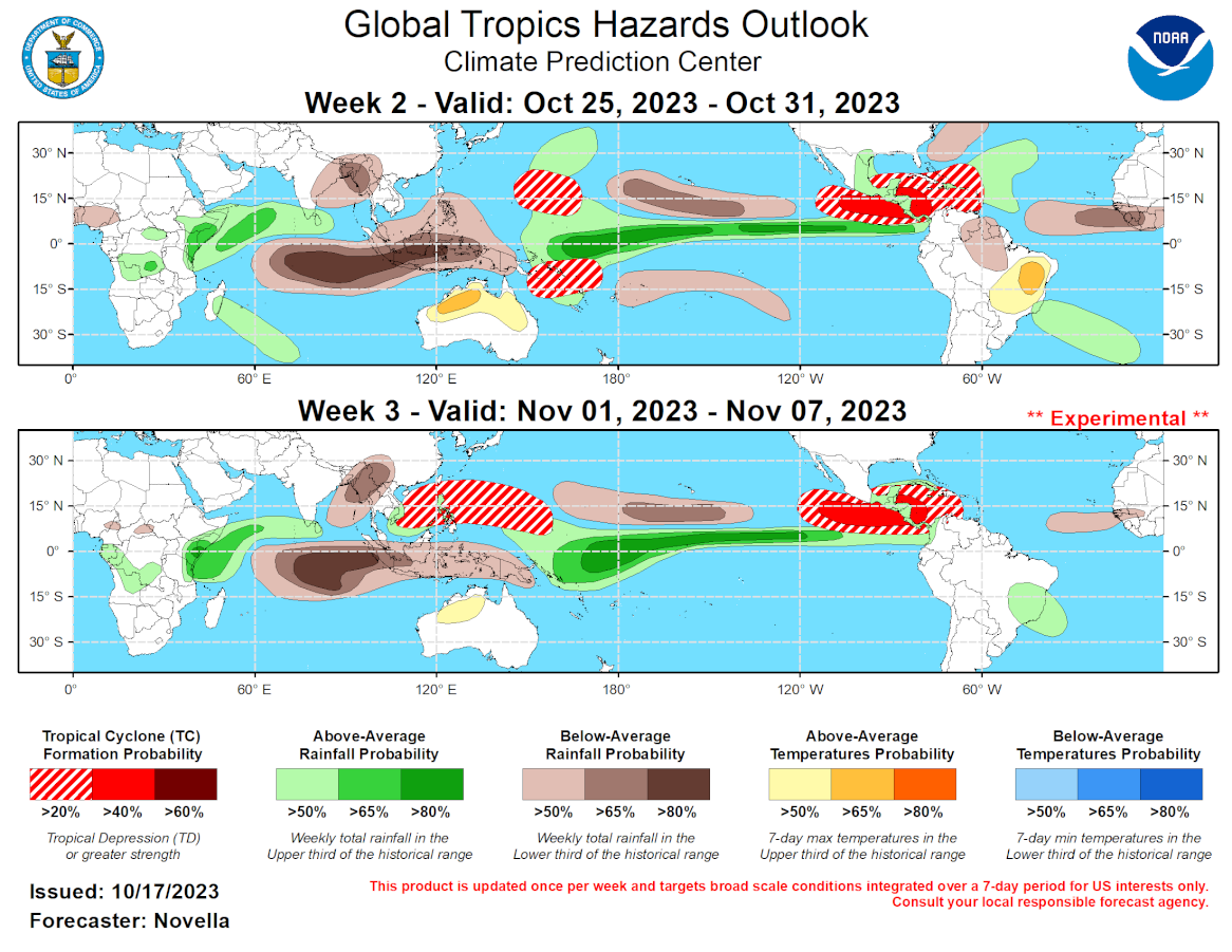
GTH Outlook Discussion Last Updated - 10/17/23 Valid - 10/25/23 - 11/07/23 The Madden Julian Oscillation (MJO) showed signs of renewed activity since early October, however the intraseasonal signal has since become less coherent during the past week. This is supported in the RMM observations depicting a westward retreating signal over the western Hemisphere and the breakdown of a wave-1 structure in the upper-level velocity potential anomaly fields during the past several days. The disorganization of the MJO is likely due to large-scale competing influences from ongoing El Nino conditions as well as an emerging positive Indian Ocean Dipole (+IOD) event, as destructive interference with these low frequency modes are likely to curtail any coherent MJO signal moving forward. An incoherent MJO is generally favored in the RMM forecasts, which show much of the intraseasonal activity remaining in the western Hemisphere that eventually retreats and regains some amplitude over the western Pacific. The thinking is that this westward shifting behavior in RMM space is tied in part to the strengthening lower-level wind response of the +IOD, as well as another equatorial Westerly Wind Burst (WWB) event that is forecast mainly west of the Date Line in the next week or so. This WWB event looks to increase chances for Tropical Cyclone (TC) formation in the western Pacific, but it also implicates further reinforcement of the El Nino response in the coming weeks or months via additional downwelling oceanic Kelvin wave activity. A more progressive intraseasonal outlook perspective is found in the objectively filtered OLR and upper-level velocity potential anomaly forecasts. While these forecasts also favor weakened MJO activity during the next few weeks, the ECMWF and CFS mean solutions favor a reduction of the suppressed low frequency footprint over the Indian Ocean (+IOD) coincident with the passage of an eastward propagating convective feature. As a result, the continued eastward propagation of the MJO over the Indian Ocean and Maritime Continent cannot be ruled out, though there is still a good deal of uncertainty in regards to the strength and evolution of intraseasonal activity, and the outlook therefore relies more on the +IOD and El Nino signals driving the global tropical convective pattern. During the last week, two TCs formed in the global tropics. TC Sean formed In the Main Development Region (MDR) of the Atlantic on 10/11, and underwent fluctuations in strength while tracking northwest over open waters before becoming post-tropical on 10/15. In the western Pacific, TC 16W formed in the South China Sea on 10/17. The Joint Typhoon Warning Center (JTWC) expects 16W to briefly track northwestward and peak at Tropical Storm intensity, then curve southward under the influence of subtropical riding and weaken later this week. Regardless of landfall, the system is expected to bring locally heavy precipitation to parts of southern China and Vietnam based on deterministic guidance. Though not officially formed at the time of this writing (2pm EDT), the NHC expects invest 90E to form in the eastern Pacific later today. In the wake of TC Sean, the National Hurricane Center (NHC) is monitoring another area in the MDR (invest 94L) with 80% chances for formation during the next week. Following this potential system, TC activity looks to quiet down throughout the MDR as TC potential looks to shift westward during week-2. Extended range guidance favors the development of anomalous lower-level westerlies extending from the eastern Pacific to the Caribbean, with anomalous easterlies emerging over the Gulf of Mexico and western Atlantic consistent with the formation of a Central American Gyre (CAG). Given climatology, and a decreasing shear environment also favored by the GEFS and ECMWF possibly tied to the departing enhanced MJO envelope, 40% chances for TC formation are highlighted, with a broad area of 20% chances posted from the south of Mexico to the western Atlantic. By week-3, much of the broad scale lower-level cyclonic circulation over the tropical Americas looks to remain established based on extended range wind guidance, and 40% chances for TC development are likewise highlighted which is also supported by probabilistic TC genesis tools. With the aforementioned WWB favored in the western Pacific, probabilistic TC genesis tools indicate elevated chances for TC formation to the west of the Date Line on both sides of the equator. Although these tools and raw model guidance suggest formation is more likely to occur late in week-1, 20% chances for TC genesis are posted to the east of the Marianas and near the Solomon Islands for week-2 should there be any delay in formation. Based on climatology, any TC development in the South Pacific in late October would be considered quite early, but not unprecedented. For week-3, 20% chances for TC formation are issued over the western Pacific, with its coverage extending further west into the South China and Philippine Seas, where conditions appear more favorable for development compared to week-2. Forecasts for enhanced and suppressed rainfall are based on a historical skill weight blend of GEFS, ECMWF, CFS and Canadian ensemble forecasts, potential TC tracks, and the anticipated dominance of the stationary +IOD and El Nino signals. For temperatures, above-normal conditions remain favored throughout portions of South America which may continue to adversely impact agriculture. Consistent with the strengthening +IOD, unusually hot conditions are also favored for many parts of Australia. For hazardous weather conditions in your area in the coming weeks, please refer to your local NWS office, the Medium Range Hazards Forecast produced by the Weather Prediction Center, and the CPC Week-2 Hazards Outlook. Forecasts made over Africa are made in coordination with the International Desk at CPC.
