Menu

3 Week Tropical Cyclone Formation Probability//1909utc


CLICK ON THE IMAGERIES BELOW TO GET THEM ENLARGED

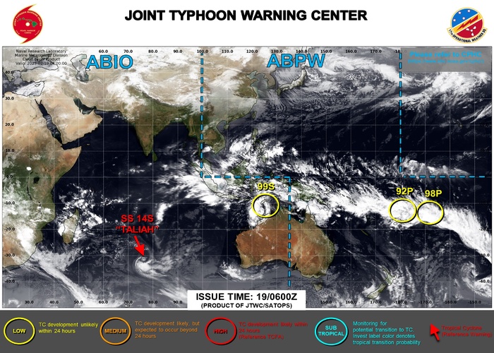
JTWC IS ISSUING 3 HOURLY SATELLITE BULLETINS ON SUBTROPICAL CYCLONE 14S AND ON INVEST 99S.

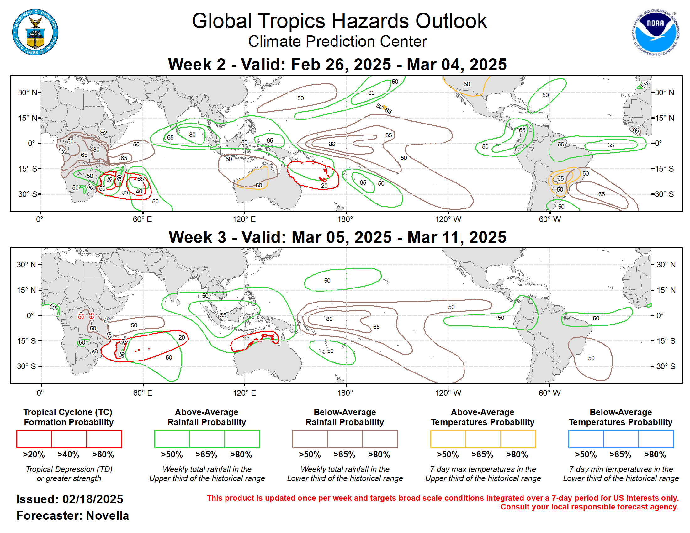
Last Updated - 02/18/25 3 WEEK TROPICAL CYCLONE FORMATION PROBABILITY
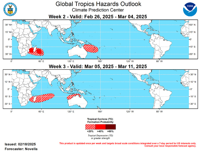
GTH Outlook Discussion Last Updated - 02/18/25 Valid - 02/26/25 - 03/11/25 The Madden-Julian Oscillation (MJO) continues to be active amid an emerging La Nina background state since the start of 2025. RMM observations show the enhanced phase of the MJO crossing the Western Pacific, though the signal has slowed and wavered in amplitude more recently over the Western Hemisphere (phase 8). Based on objectively filtered wave forecasts, this behavior appears to be tied to strong equatorial Rossby Wave activity where a westward moving envelope of enhanced divergence (convergence) aloft looks to destructively interfere with the suppressed (enhanced) phase of the MJO over the global tropics during the next week or so. However, any disorganization of the MJO looks to be temporary, as RMM forecasts generally feature a more steady eastward propagation of the signal entering the Indian Ocean. Although many mean model solutions weaken the signal within the RMM unit circle, several ensemble members depict a higher amplitude event over the Indian Ocean, and the GEFS and ECWMF upper-level velocity potential anomaly forecasts favor more of a wave-1 pattern taking shape, consistent with reorganizing MJO activity towards the end of February. Therefore, the updated GTH outlook points to a renewed Tropical Cyclone (TC) formation potential in the southern Indian Ocean, with decreasing chances for development over the South Pacific. Should the MJO remain coherent while propagating over the Indian Ocean by weeks 2 and 3, the MJO appears poised to again constructively interfere with the low frequency footprints over the Maritime Continent and equatorial Pacific. It is also worth noting that a potential late winter extratropical response of a phase 1 and 2 MJO features a retrograding mean longwave trough over North America. This would signal the return of warmer temperatures over the eastern U.S., with the potential for enhanced onshore flow over western North America later in March.  No TCs formed during the past week, with one TC (Taliah) remaining active over the southern Indian Ocean. Since forming back on 2/2 over the Timor Sea, Taliah has steadily tracked westward where it is now located near 80E/30S at Tropical Storm intensity. Having gained latitude over the past several days, the Joint Typhoon Warning Center (JTWC) expects Taliah to become absorbed in the westerlies and dissipate during the next few days over open waters. During week-1, there continues to be good model agreement for additional TC development to the north of Australia in the wake of TC Zelia that brought many adverse impacts to western Australia during the past week. TC development is also favored over the South Pacific to the east of the Date Line during the next few days, and please refer to the JTWC for updates on these potential systems.  Late in week-1, there continues to be good model support for TC development over the southwestern Indian Ocean where one or more tropical lows are favored to form. While the ECMWF ensemble is quicker to deepen a mean low in the Mozambique Channel and to the east of Madagascar, several ensemble members from the GEFS are more delayed with this potential with a hostile shear environment favored to persist over the region late in week-1. Therefore, 40% chances for development are posted mainly south of 20S, with a broader area of 20% chances extending eastward to 65E for week-2. Similarly, there is good support for one or more TCs forming over the Coral Sea late in week-1 or early in Week-2, however only 20% chances are posted given differences in the timing and location in the guidance. Likely tied to the aforementioned Rossby wave activity favored, probabilistic tools also point to potential genesis over the Bay of Bengal, western Pacific, and southeastern Indian Ocean. However, there is not enough confidence to post any corresponding TC areas due to a quiet TC climatology north of the equator, and the easterly phase of the MJO favored to the north of Australia during week-2.  With the enhanced phase of the MJO favored to overspread the Indian Ocean, the environment is expected to remain favorable for additional TC development over the southwestern Indian Ocean, with increasing chances extending into the south-central portion of the basin. Given this, based on both probabilistic tools and MJO composites, a broad area of 20% chances is posted from the Mozambique Channel eastward to approximately 80E for week-3. Farther east, there is increased support in the extended range probabilistic tools for TC development further east to the north of Australia, and 20% chances are issued where enhanced easterlies are favored to relax with equatorial Rossby wave activity also favored.
GTH Outlook Discussion Last Updated - 02/18/25 Valid - 02/26/25 - 03/11/25 The Madden-Julian Oscillation (MJO) continues to be active amid an emerging La Nina background state since the start of 2025. RMM observations show the enhanced phase of the MJO crossing the Western Pacific, though the signal has slowed and wavered in amplitude more recently over the Western Hemisphere (phase 8). Based on objectively filtered wave forecasts, this behavior appears to be tied to strong equatorial Rossby Wave activity where a westward moving envelope of enhanced divergence (convergence) aloft looks to destructively interfere with the suppressed (enhanced) phase of the MJO over the global tropics during the next week or so. However, any disorganization of the MJO looks to be temporary, as RMM forecasts generally feature a more steady eastward propagation of the signal entering the Indian Ocean. Although many mean model solutions weaken the signal within the RMM unit circle, several ensemble members depict a higher amplitude event over the Indian Ocean, and the GEFS and ECWMF upper-level velocity potential anomaly forecasts favor more of a wave-1 pattern taking shape, consistent with reorganizing MJO activity towards the end of February. Therefore, the updated GTH outlook points to a renewed Tropical Cyclone (TC) formation potential in the southern Indian Ocean, with decreasing chances for development over the South Pacific. Should the MJO remain coherent while propagating over the Indian Ocean by weeks 2 and 3, the MJO appears poised to again constructively interfere with the low frequency footprints over the Maritime Continent and equatorial Pacific. It is also worth noting that a potential late winter extratropical response of a phase 1 and 2 MJO features a retrograding mean longwave trough over North America. This would signal the return of warmer temperatures over the eastern U.S., with the potential for enhanced onshore flow over western North America later in March. No TCs formed during the past week, with one TC (Taliah) remaining active over the southern Indian Ocean. Since forming back on 2/2 over the Timor Sea, Taliah has steadily tracked westward where it is now located near 80E/30S at Tropical Storm intensity. Having gained latitude over the past several days, the Joint Typhoon Warning Center (JTWC) expects Taliah to become absorbed in the westerlies and dissipate during the next few days over open waters. During week-1, there continues to be good model agreement for additional TC development to the north of Australia in the wake of TC Zelia that brought many adverse impacts to western Australia during the past week. TC development is also favored over the South Pacific to the east of the Date Line during the next few days, and please refer to the JTWC for updates on these potential systems. Late in week-1, there continues to be good model support for TC development over the southwestern Indian Ocean where one or more tropical lows are favored to form. While the ECMWF ensemble is quicker to deepen a mean low in the Mozambique Channel and to the east of Madagascar, several ensemble members from the GEFS are more delayed with this potential with a hostile shear environment favored to persist over the region late in week-1. Therefore, 40% chances for development are posted mainly south of 20S, with a broader area of 20% chances extending eastward to 65E for week-2. Similarly, there is good support for one or more TCs forming over the Coral Sea late in week-1 or early in Week-2, however only 20% chances are posted given differences in the timing and location in the guidance. Likely tied to the aforementioned Rossby wave activity favored, probabilistic tools also point to potential genesis over the Bay of Bengal, western Pacific, and southeastern Indian Ocean. However, there is not enough confidence to post any corresponding TC areas due to a quiet TC climatology north of the equator, and the easterly phase of the MJO favored to the north of Australia during week-2. With the enhanced phase of the MJO favored to overspread the Indian Ocean, the environment is expected to remain favorable for additional TC development over the southwestern Indian Ocean, with increasing chances extending into the south-central portion of the basin. Given this, based on both probabilistic tools and MJO composites, a broad area of 20% chances is posted from the Mozambique Channel eastward to approximately 80E for week-3. Farther east, there is increased support in the extended range probabilistic tools for TC development further east to the north of Australia, and 20% chances are issued where enhanced easterlies are favored to relax with equatorial Rossby wave activity also favored.

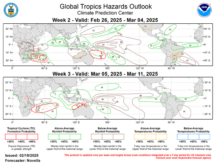
Forecasts for enhanced and suppressed precipitation are based on the continued La Nina response, historical MJO composites for phases 1-3 during Jan-Mar, anticipated TC tracks, and a skill weighted consolidation of GEFS, CFSv2, ECWMF ensemble forecast systems. Following an outbreak of Arctic air mainly east of the North American Rockies during week-1, a fairly swift moderation of temperatures are expected, with above-normal conditions favored for much of the western and central CONUS for week-2. South of the equator, above-normal temperatures are expected to accompany the dryness forecast for much of northwestern Australia, with increased chances for daytime temperatures exceeding 105 deg F during week-2. Above-normal temperatures are also favored for portions of east-central South America.


Rédigé par PATRICK HOAREAU le Wednesday, February 19th 2025 à 13:15