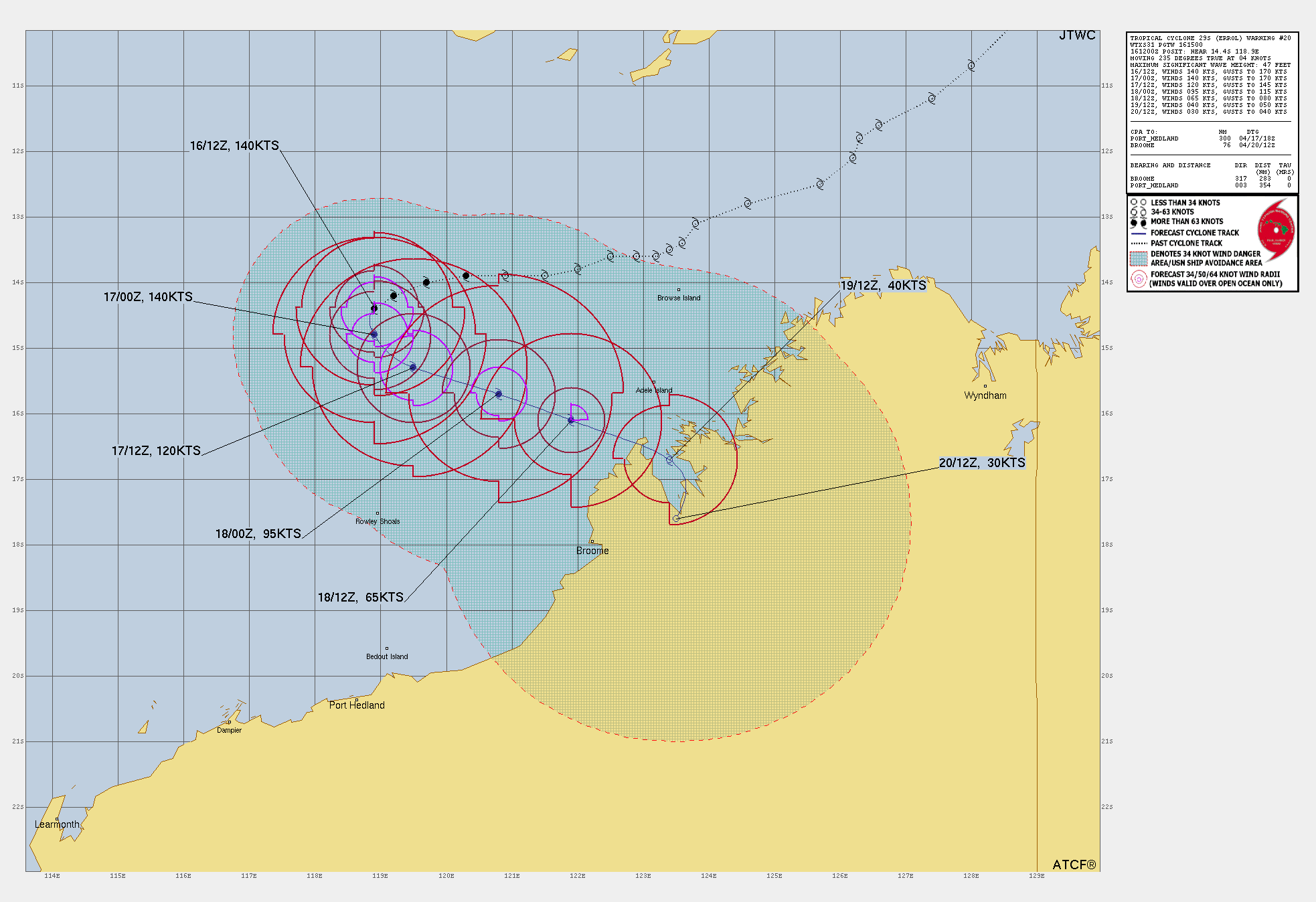
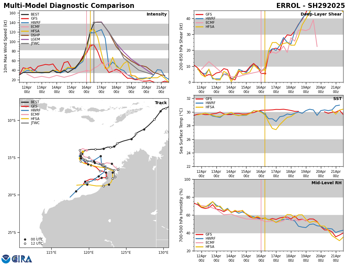
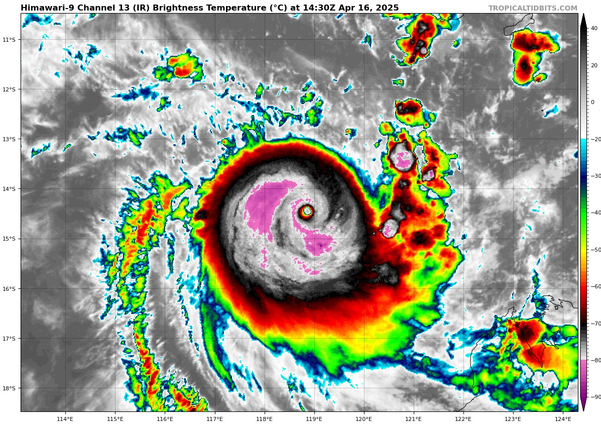
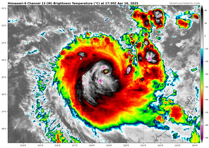
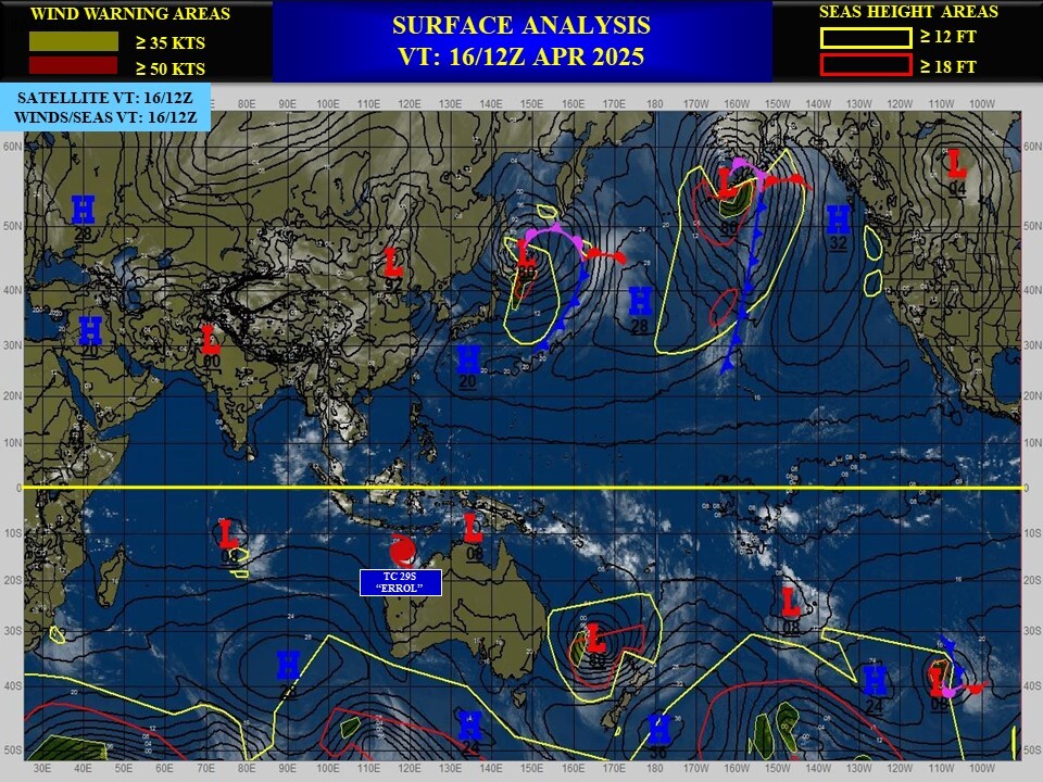
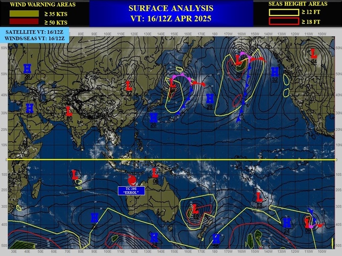
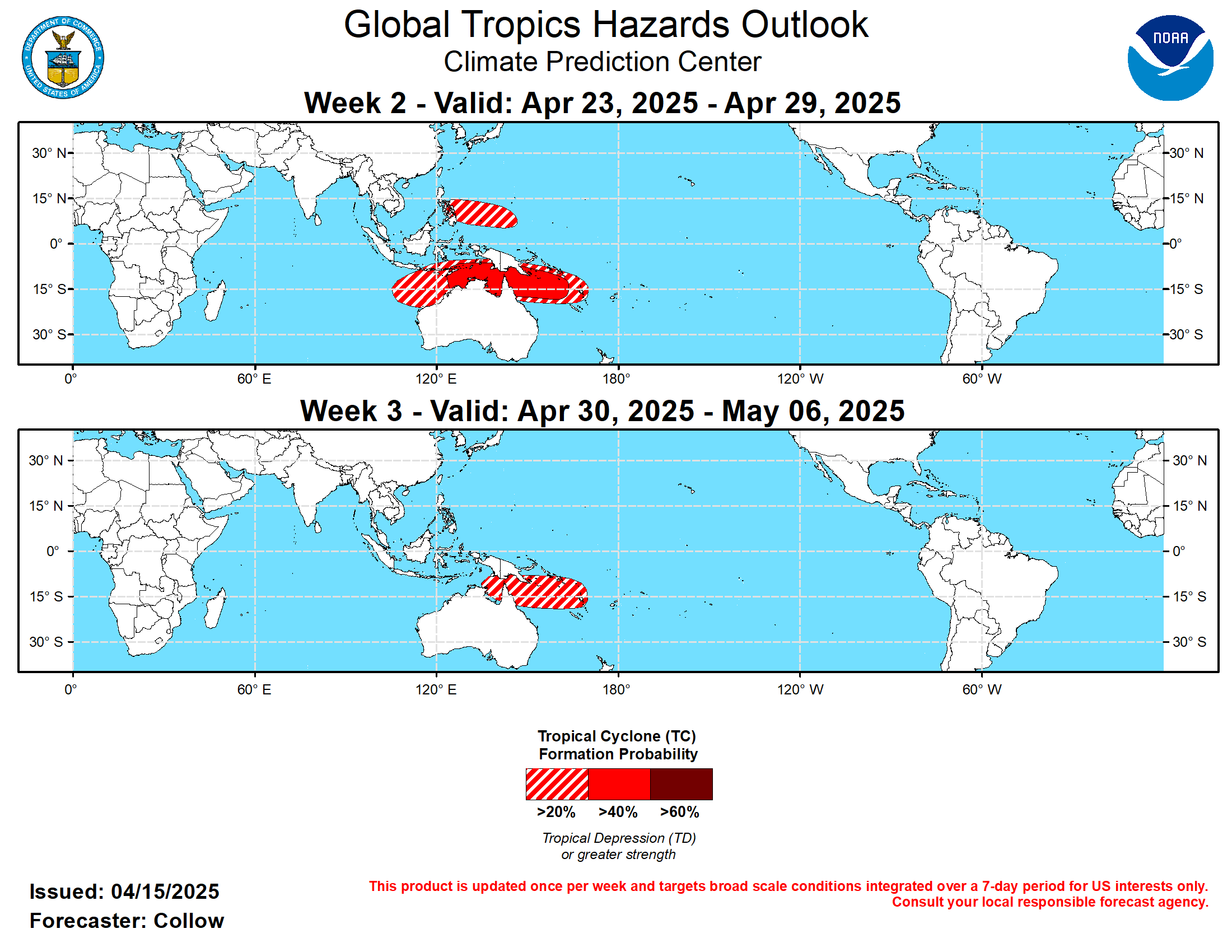
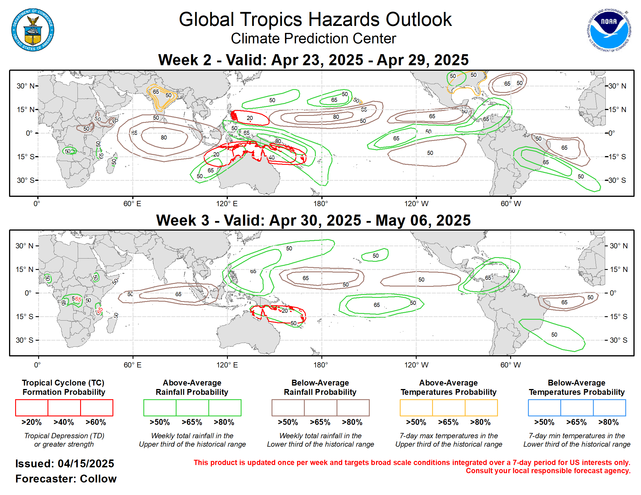
CLICK ON THE IMAGERIES BELOW TO GET THEM ENLARGED
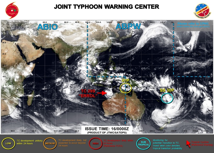
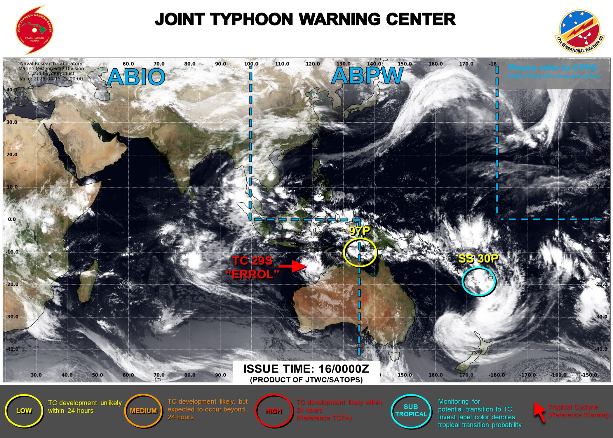
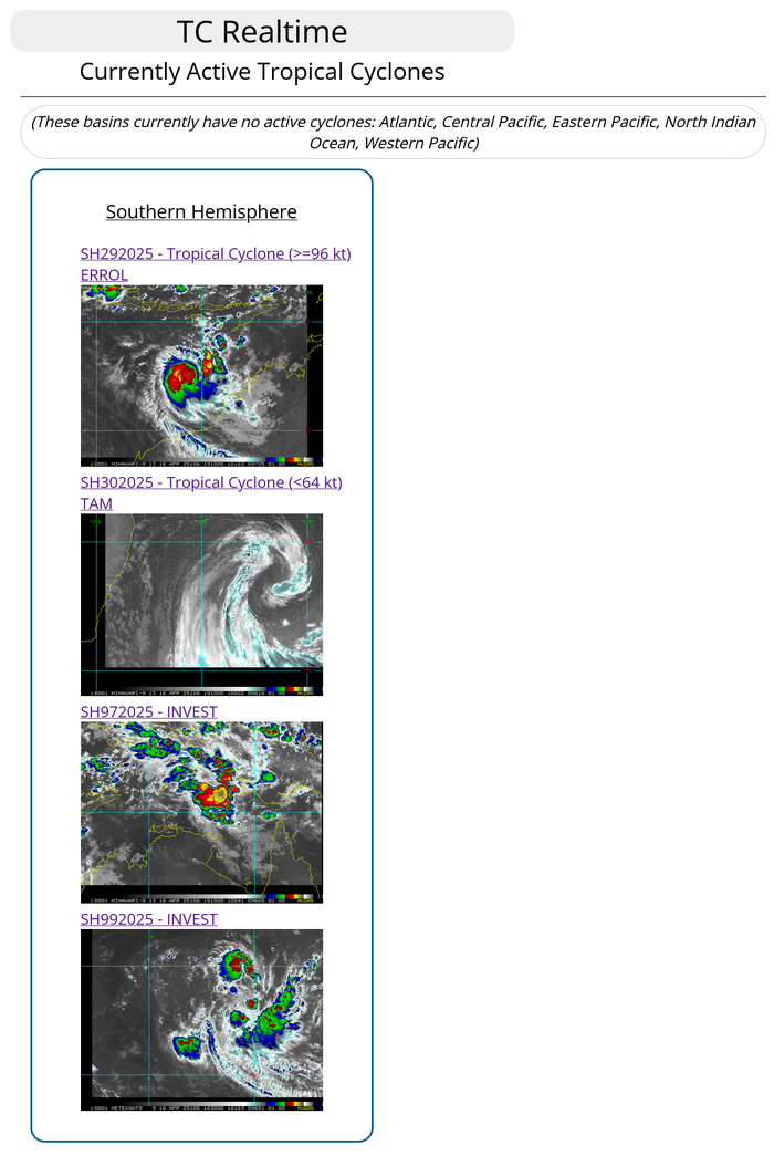
JTWC IS ISSUING 6 HOURLY WARNINGS AND 3 HOURLY SATELLITE BULLETINS ON TC 29S(ERROL). 3 HOURLY SATELLITE BULLETINS ARE ISSUED ON SUBTROPICAL STORM 30P.
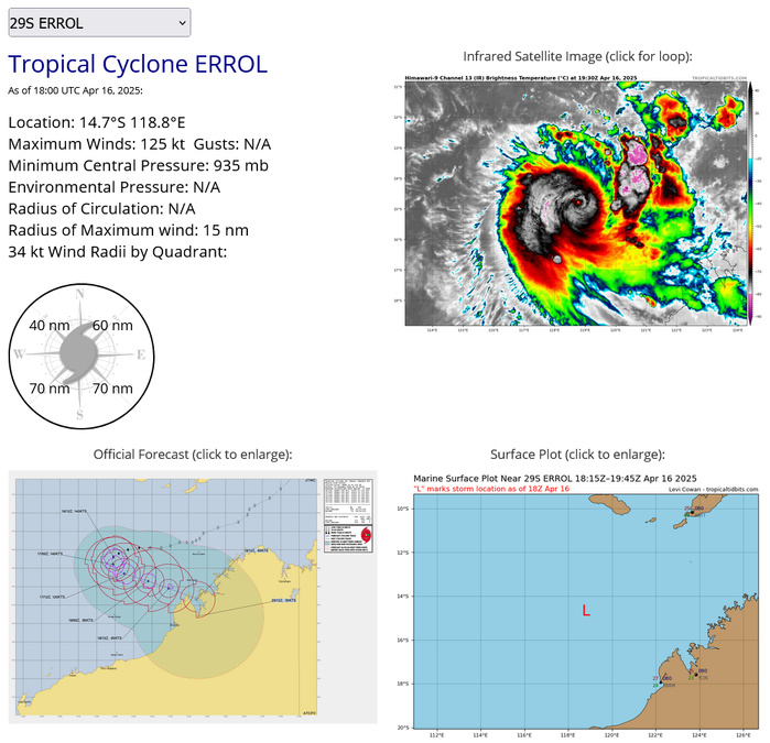
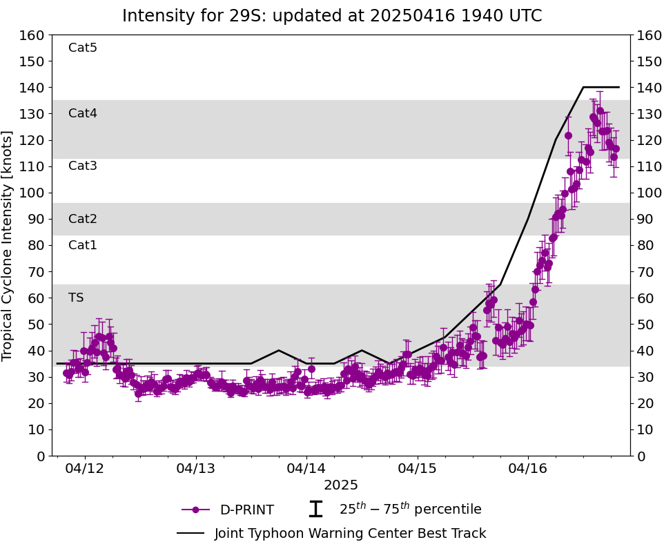
SOUTH INDIAN OCEAN: TC 29S(ERROL). 16/18UTC ESTIMATED INTENSITY AND LOCATION. INTENSITY IS 125 KNOTS CAT 4 US.
AT 16/12UTC TC 29S PEAKED AT 140 KNOTS CATEGORY 5 / SUPER TYPHOON
2925041118 107S1280E 35
2925041200 112S1274E 35
2925041206 116S1266E 35
2925041212 118S1263E 35
2925041218 121S1262E 35
2925041300 125S1257E 35
2925041306 128S1246E 35
2925041312 131S1238E 35
2925041318 134S1236E 40
2925041400 135S1234E 35
2925041406 136S1232E 35
2925041412 136S1229E 40
2925041418 136S1225E 35
2925041500 138S1220E 40
2925041506 139S1215E 45
2925041512 139S1209E 55
2925041518 139S1203E 65
2925041600 140S1197E 90
2925041606 142S1192E 120
2925041612 144S1189E 140
2925041618 147S1188E 125
CLICK ON THE IMAGERY BELOW TO GET IT ANIMATED AND ENLARGED
WARNING 20 ISSUED AT 16/15UTC
WDXS31 PGTW 161500
MSGID/GENADMIN/JOINT TYPHOON WRNCEN PEARL HARBOR HI//
SUBJ/PROGNOSTIC REASONING FOR TROPICAL CYCLONE 29S (ERROL) WARNING NR
020//
RMKS/
1. FOR METEOROLOGISTS.
2. 6 HOUR SUMMARY AND ANALYSIS.
SUMMARY:
INITIAL POSITION: 14.4S 118.9E
INITIAL INTENSITY: 140 KTS
GEOGRAPHIC REFERENCE: 283 NM NORTHWEST OF BROOME, AUSTRALIA
MOVEMENT PAST 6 HOURS: SOUTHWESTWARD AT 04 KTS
SIGNIFICANT WAVE HEIGHT: 47 FEET
SATELLITE ANALYSIS, INITIAL POSITION AND INTENSITY DISCUSSION:
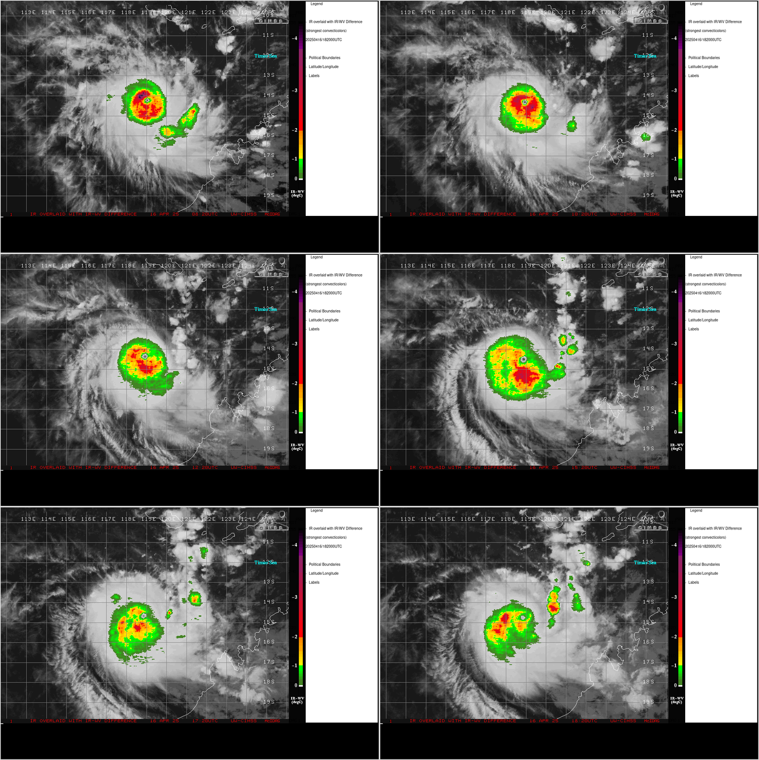
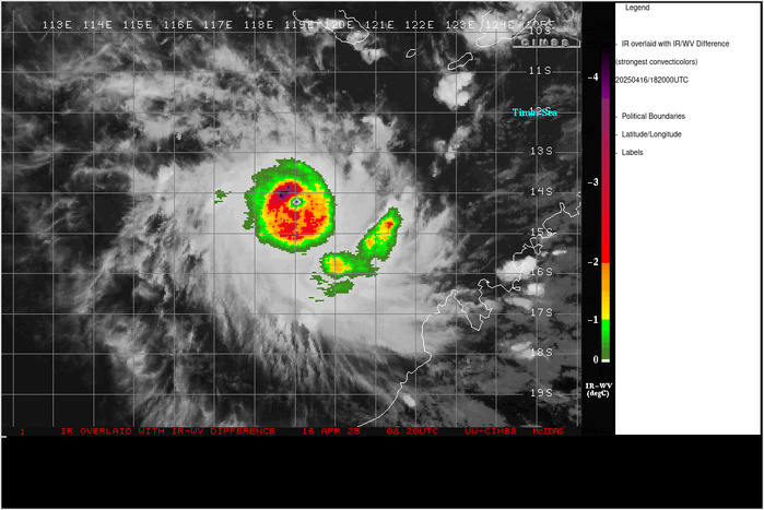
TROPICAL CYCLONE (TC) 29S (ERROL) CUTS AN IMPRESSIVE LOOK IN THE
ANIMATED ENHANCED INFRARED (EIR) SATELLITE IMAGERY, WITH AN
APPROXIMATELY 8NM WIDE EYE SURROUNDED BY A SOLID CENTRAL DENSE
OVERCAST (CDO) FEATURE. THE EYE TEMP AT 161200Z WAS MEASURED A
WHOPPING POSITIVE 15C IN THE HIMAWARI-9 BD-ENHANCEMENT. TC 29S HAS
UNDERGONE AN AMAZING PERIOD OF EXTREME RAPID INTENSIFICATION (ERI),
INTENSIFYING 85 KNOTS IN THE LAST 24 HOURS, AND MORE THAN 50 KNOTS
IN JUST THE LAST 12 HOURS. A SERIES OF MICROWAVE PASSES BETWEEN
160741Z AND 1610005Z SUGGEST THAT TC ERROL COMPLETED A RAPID
EYEWALL REPLACEMENT CYCLE (ERC) DURING THAT TIMEFRAME, WHICH IS
BACKED UP BY THE CIMSS M-PERC PRODUCT WHICH PREDICTED A 96 PERCENT
PROBABILITY OF AN IMMINENT ERC AT 1000Z. THE MOST RECENT FRAMES OF
EIR SHOW THE EYE DIAMETER WIDENING EVER SO SLIGHTLY POTENTIALLY IN
RESPONSE TO COMPLETION OF THE SHORT-DURATION ERC. THE INITIAL
POSITION IS ASSESSED WITH HIGH CONFIDENCE BASED ON THE EYE
DEPICTION IN THE EIR. TC 29S HAS LIKELY REACHED PEAK INTENSITY,
WITH THE INITIAL INTENSITY OF 140 KNOTS ASSESSED WITH MEDIUM
CONFIDENCE. DVORAK CURRENT INTENSITY ESTIMATES FROM BOTH PGTW AND
KNES WERE HELD AT T6.5 DUE TO CONSTRAINTS BUT BOTH AGENCIES
REPORTED DATA-T VALUES OF T7.5. OBJECTIVE ESTIMATES REMAIN BIASED
LOW DUE TO THE EXTREMELY SMALL SIZE OF THE SYSTEM. THE INITIAL
INTENSITY IS HEDGED UPWARDS TO TAKE INTO ACCOUNT THE HIGHER DATA-T
VALUES. THE ENVIRONMENT REMAINS FAVORABLE THOUGH SHEAR IS ALREADY
STARTING TO INCREASE SLIGHTLY. SSTS REMAIN VERY WARM AND THE
OUTFLOW ALOFT REMAINS STRONG.
INITIAL WIND RADII BASIS: PERSISTENCE
CURRENT STEERING MECHANISM: WEAK STEERING PATTERN.
AGENCY DVORAK AND AUTOMATED FIXES:
PGTW: T6.5 - 127 KTS
KNES: T6.5 - 127 KTS
DEMS: T6.5 - 127 KTS
APRF: T5.5 - 102 KTS
CIMSS SATCON: 117 KTS AT 161200Z
CIMSS ADT: 119 KTS AT 161230Z
CIMSS AIDT: 118 KTS AT 161230Z
CIMSS D-MINT: 108 KTS AT 161039Z
CIMSS D-PRINT: 112 KTS AT 161230Z
FORECASTER ASSESSMENT OF CURRENT ENVIRONMENT: FAVORABLE
VWS: 10-15 KTS
SST: 29-30 CELSIUS
OUTFLOW: STRONG RADIAL
OTHER FACTORS: ENHANCED POLEWARD OUTFLOW CHANNEL.
ANALYSIS CONFIDENCE:
INITIAL POSITION: HIGH
INITIAL INTENSITY: MEDIUM
INITIAL WIND RADII: MEDIUM
3. FORECAST REASONING.
SIGNIFICANT FORECAST CHANGES: THERE ARE NO SIGNIFICANT CHANGES TO
THE FORECAST FROM THE PREVIOUS WARNING.
FORECAST DISCUSSION: TC 29S IS CURRENTLY DRIFTING SOUTHWARD IN A
WEAK STEERING PATTERN CAUSED BY A BREAK IN THE STR TO THE SOUTH
AHEAD OF AN APPROACHING DEEP UPPER-LEVEL TROUGH. OVER THE NEXT 12
TO 24 HOURS, THE SYSTEM WILL TURN SHARPLY TO THE SOUTHEAST ALONG
THE WESTERN SIDE OF A SMALL UPPER-LEVEL ANTICYCLONE OVER CAPE
TALBOT THAT RAPIDLY WEAKENS AND MOVES EQUATORWARD. THEREAFTER THE
PRIMARY STEERING INFLUENCE BECOMES THE DEEP TROUGH TO THE SOUTHWEST
WHICH WILL PULL TC 29S ALONG TOWARDS THE SOUTHEAST, EMBEDDED IN THE
DEEP NORTHWESTERLY FLOW AHEAD OF THE TROUGH. THE SYSTEM IS FORECAST
TO MAKE LANDFALL JUST PRIOR TO TAU 72 NEAR CAPE LEVEQUE, THEN
TURNING SOUTHWARD BEFORE DISSIPATING IN THE VICINITY OF DERBY BAY
THE END OF THE FORECAST. TC 29S IS LIKELY AT PEAK INTENSITY, THOUGH
IT IS POSSIBLE IT COULD SQUEEZE OUT ANOTHER FIVE KNOTS. HOWEVER,
THE MOST RECENT EIR IMAGERY AT 161340Z SHOWS THE EASTERN SIDE OF
THE EYEWALL STARTING TO WEAKEN FAIRLY DRAMATICALLY, WHICH MAY
INDICATE THE BEGINNING OF THE END FOR TC ERROL. SHEAR IS ALREADY UP
TO 14 KNOTS PER THE LATEST CIMSS ANALYSIS, UP FROM JUST 8 KNOTS SIX
HOURS AGO. THE GFS MODEL SOUNDINGS INDICATE A RAPID INCREASE IN
SHEAR TO NEAR 25 KNOTS BY TAU 12, INCREASING TO MORE THAN 35 KNOTS
BY TAU 24. THE SYSTEM WILL LIKELY MAINTAIN INTENSITY THROUGH TAU 12
BEFORE THE SHEAR REALLY STARTS TO TAKE EFFECT. HOWEVER, THE EFFECT
OF THE SHEAR WILL BE DRAMATIC FROM TAU 24 ONWARDS. HAFS-A
CROSS-SECTIONS DEPICT A RAPID AND DRAMATIC DECAPITATION EVENT, WITH
THE VORTEX BEING COMPLETELY DECIMATED BY TAU 24. WHILE THE RATE OF
INTENSIFICATION HAS BEEN INCREDIBLE, THE PACE OF THE WEAKENING
WILL LIKELY BE EQUALLY IMPRESSIVE. THE SYSTEM WILL BE DOWN TO
TROPICAL STORM STRENGTH WITHIN 48 HOURS AND WILL DISSIPATE ALONG
THE COAST NO LATER THAN TAU 96.
MODEL DISCUSSION: DETERMINISTIC TRACK GUIDANCE IS IN FAIR AGREEMENT
THROUGH TAU 48, WITH ALL MEMBERS OF THE CONSENSUS CONCURRING ON A
SHORT PERIOD OF QUASI-STATIONARY OR SLOW SOUTHWARD MOVEMENT,
FOLLOWED BY A RAPID TRANSITION TO A SOUTHEASTWARD TRACK BY TAU 24.
MODELS BEGIN TO DIVERGE AFTER TAU 24, WITH CROSS-TRACK SPREAD
OPENING UP TO 155NM BY TAU 48 THOUGH AT THIS POINT IN THE FORECAST
ALL OF THE CONSENSUS MEMBERS ARE TRACKING THE SYSTEM RIGHT AT THE
COAST. BY TAU 72, CROSS-TRACK SPREAD OPENS UP TO 255NM BETWEEN THE
GFS-GEFS COMBO ON THE LEFT, TURNING THE SYSTEM SOUTHWEST JUST
NORTHWEST OF BROOME AND THE EC-AIFS TO THE RIGHT, TAKING THE SYSTEM
INLAND TO THE WEST OF WYNDHAM. BY THE END OF THE FORECAST THE
MAJORITY OF CONSENSUS MEMBERS BEGIN TO TURN THE SYSTEM
SOUTHWESTWARD THOUGH THEY ARE SPREAD OUT ACROSS A NEARLY 500NM
SWATCH FROM WEST OF BROOME TO THE NORTHERN KIMBERLY COAST. ENSEMBLE
GUIDANCE IS ALSO HIGHLY UNCERTAIN WITH A SPREAD OF MEMBERS BETWEEN
EXMOUTH AND BROOME FOR THE GEFS, AND BETWEEN CAPE TALBOT AND BROOME
FOR THE ECENS. THE JTWC FORECAST IS ROUGHLY CONSISTENT WITH THE
MULTI-MODEL CONSENSUS MEAN WITH MEDIUM CONFIDENCE. INTENSITY
GUIDANCE IS IN GOOD AGREEMENT THAT THE SYSTEM WILL RAPIDLY WEAKEN
AFTER TAU 12, BUT DOES DIFFER SIGNIFICANTLY ON HOW QUICKLY THE
SYSTEM WILL ULTIMATELY DISSIPATE, AS EARLY AS TAU 48 FOR THE
COAMPS-TC AND HWRF, OR AS LATE AS TAU 120 FOR THE HAFS-A. THE JTWC
FORECAST IS SLIGHTLY LOWER THAN THE CONSENSUS MEAN AFTER TAU 48.
FORECAST CONFIDENCE:
TRACK 0 - 72 HR: MEDIUM
TRACK 72-120 HR: LOW
INTENSITY 0 - 72 HR: MEDIUM
INTENSITY 72-120 HR: MEDIUM//
NNNN
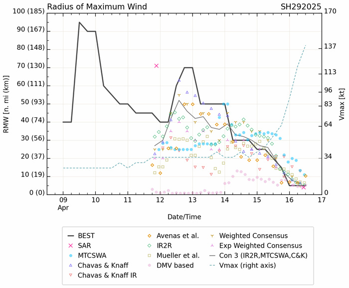
Model Diagnostic Plot
Radius of Maximum Wind (RMW
16/1430UTC SATELLITE BULLETIN: SHORTLY AFTER BEST SATELLITE PRESENTATION
TPXS10 PGTW 161518
A. TROPICAL CYCLONE 29S (ERROL)
B. 16/1440Z
C. 14.47S
D. 118.92E
E. ONE/GK2A
F. T7.0/7.0/D3.5/24HRS STT: D0.5/03HRS
G. IR/EIR
H. REMARKS: 01A/PBO EYE/ANMTN. WMG EYE SURROUNDED BY W YIELDS AN E#
OF 6.0. ADDED 1.0 EYE ADJUSTMENT FOR CMG, TO YIELD A DT OF 7.0. MET
YIELDS 5.0. PT YIELDS 5.5. DBO DT. BROKE 18-HOUR AND 24-HOUR
CONSTRAINTS DUE TO RAPID DEVELOPMENT.
I. ADDITIONAL POSITIONS:
16/1039Z 14.30S 119.02E SSMS
NEVAREZ
16/1730UTC SATELLITE BULLETIN: SIGNS OF WEAKENING
TPXS10 PGTW 161805
A. TROPICAL CYCLONE 29S (ERROL)
B. 16/1730Z
C. 14.68S
D. 118.92E
E. ONE/GK2A
F. T6.5/7.0/D3.0/24HRS STT: W0.5/03HRS
G. IR/EIR
H. REMARKS: 01A/PBO EYE/ANMTN. OW EYE SURROUNDED BY B YIELDS AN E#
OF 5.5. ADDED 0.5 EYE ADJUSTMENT FOR W, AND ADDED 0.5 FOR BF, TO
YIELD A DT OF 6.5. MET YIELDS A 5.0. PT YIELDS A 5.5. DBO DT.
I. ADDITIONAL POSITIONS: NONE
TIMMERMAN
Last Updated - 04/15/25 3 WEEK TROPICAL CYCLONE FORMATION PROBABILITY
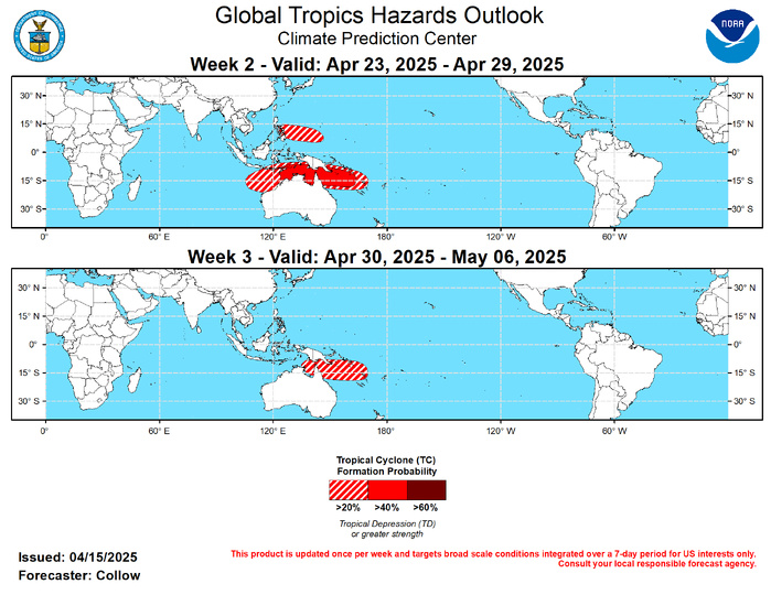
GTH Outlook Discussion Last Updated - 04/15/25 Valid - 04/23/25 - 05/06/25 The Madden Julian Oscillation (MJO) has been inactive since late March with the RMM-based index meandering within the unit circle for the past couple weeks, and a convectively coupled Kevin Wave (CCKW) likely to spread enhanced convection across the eastern Pacific by next week. ENSO-neutral conditions have returned to the tropical Pacific further limiting the tropical forcing. The ECENS and GEFS ensembles indicate a re-emergence of the MJO across the Western Pacific by week-2, but this is more likely tied to an enhanced low frequency convective state developing over the region, with limited eastward propagation. Suppressed convective activity is forecast upstream over the Indian Ocean. Despite the lack of MJO, and a decreasing climatology for tropical cyclogenesis, tropical cyclone (TC) formation was observed in the southern Indian Ocean and South Pacific during the past week. Tropical Cyclone Errol developed on April 11 over the Timor Sea (11 deg S, 128 deg E) and has been moving southwestward offshore the Kimberley Coast of Australia. Tropical Cyclone Tam formed on April 14 near Vanuatu (15 deg S, 168 deg E) and is tracking southward. Additional TC formations are possible in week-1, with Invests 97P and 99S located over the Gulf of Carpentaria and southern Indian Ocean respectively. By week-2, the increasing MJO signal across phases 6 and 7, along with reduced wind shear, support continued enhanced chances for additional TC development, with a 40-60 percent chance highlighted from the Timor Sea eastward through the Coral Sea. A broader 20-40 percent area stretches from off the northwest Australia coast to Vanuatu. By week-3, climatology wanes significantly, and the MJO may shift more into phases 7 and 8. This would favor reduced confidence for TC formation further west, but continued enhanced TC activity is not ruled out across the Gulf of Carpentaria and Coral Sea where 20-40 percent chances are posted. Across the western north Pacific, individual GEFS and ECENS ensemble members depict surface low pressure tracking to the east of the Philippines tied to the enhanced convective envelope developing over the region. There is some uncertainty regarding the tropical nature of this system versus frontal influence. However, given the favorable convective environment aloft and support from MJO composites, a 20-40 percent chance for TC formation is highlighted over the area. Similar dynamics may continue into week-3 given the nearly stationary convective envelope. However, the uncertainty combined with the longer lead precludes continuing the 20-40 percent risk area, and this time frame will be reassessed next week.
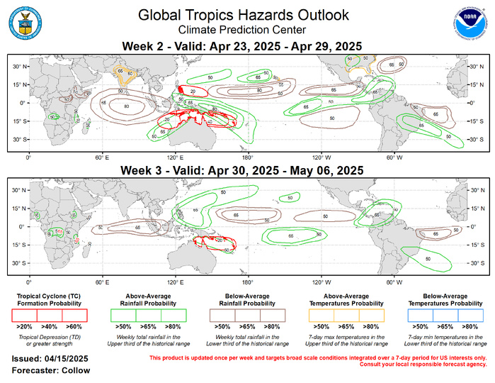
Forecasts for enhanced and suppressed precipitation are mainly based on a consolidated skill weighted blend of GEFS, CFSv2, and ECMWF ensemble systems, anticipated TC tracks, with some consideration of historical MJO composites for Mar-May for phases 6-8. Less emphasis is given to ENSO given the return to neutral conditions. Above-normal rainfall is forecast across the Western Pacific and Maritime Continent, with below-normal rainfall upstream over the Indian Ocean. Surface low pressure across the central Pacific may bring some enhanced rainfall in the vicinity of Hawaii. Above-normal temperatures are favored over parts of India, with daytime maximum temperatures possibly exceeding 100 deg F during week-2. Above-normal temperatures are also predicted across the south-central and southeastern U.S.
