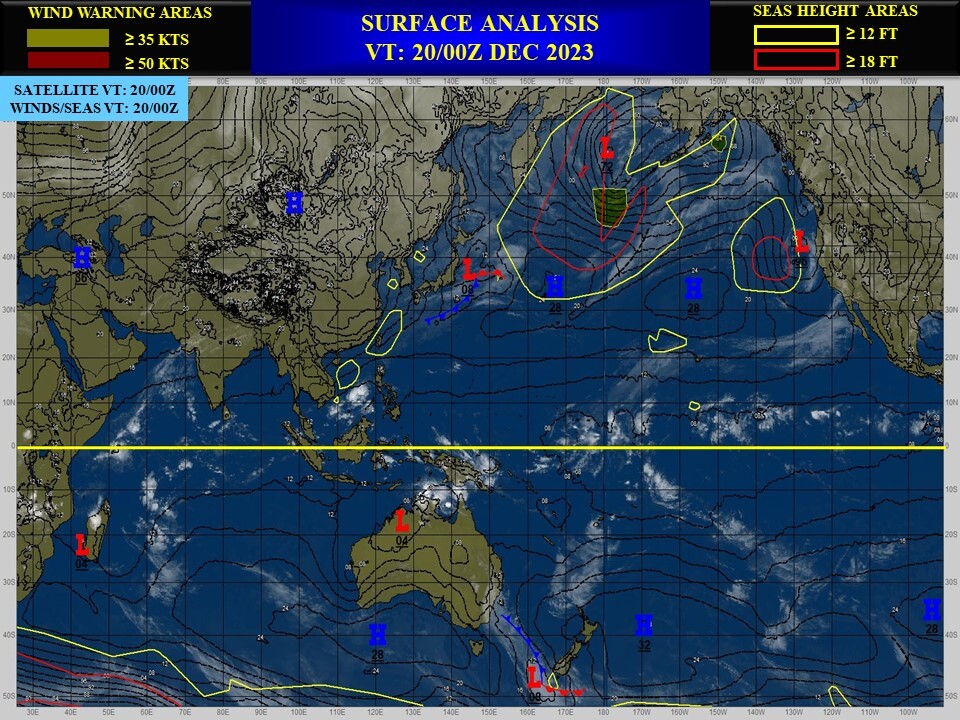
CLICK ON THE IMAGERIES BELOW TO GET THEM ENLARGED
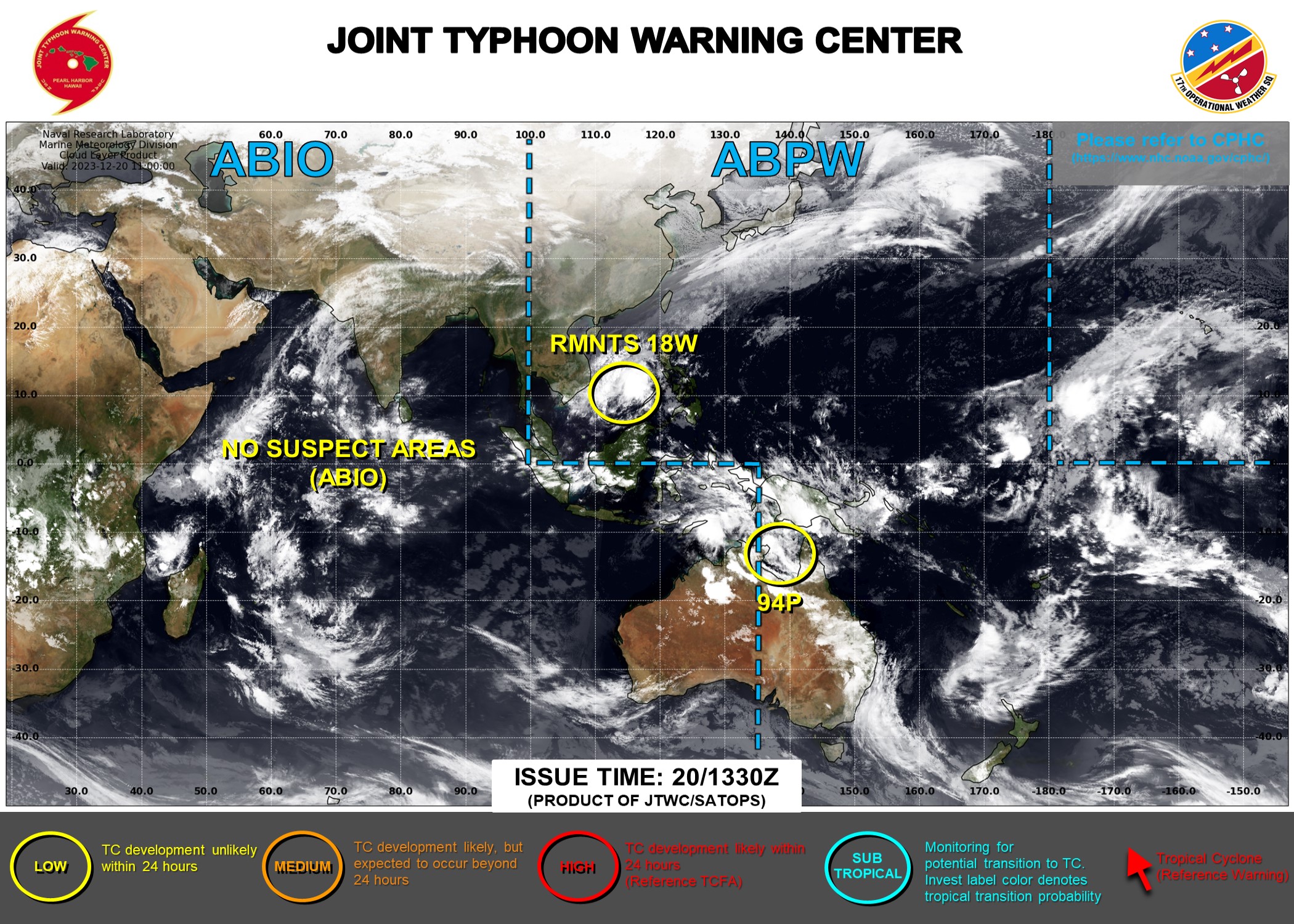
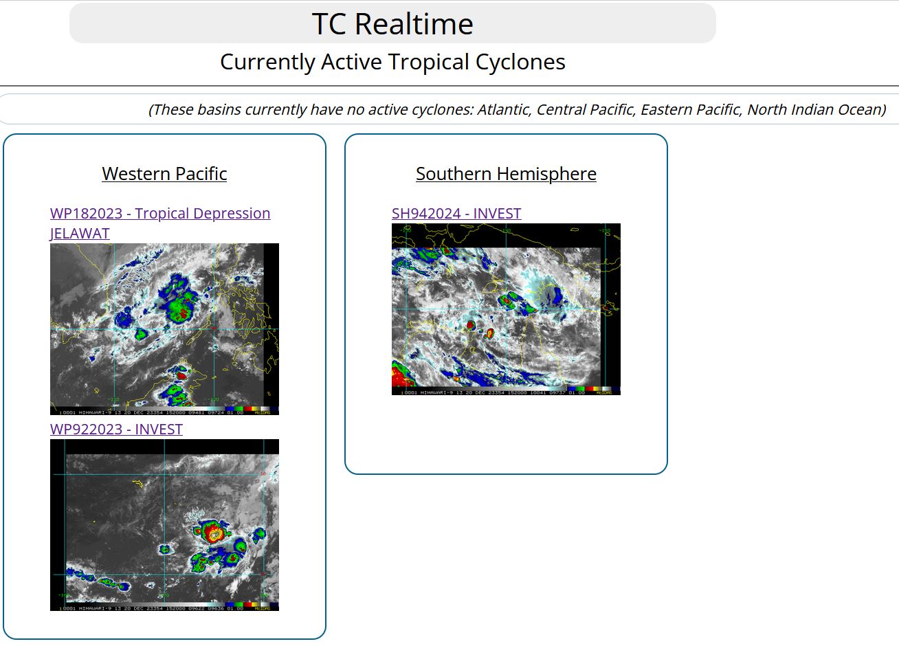
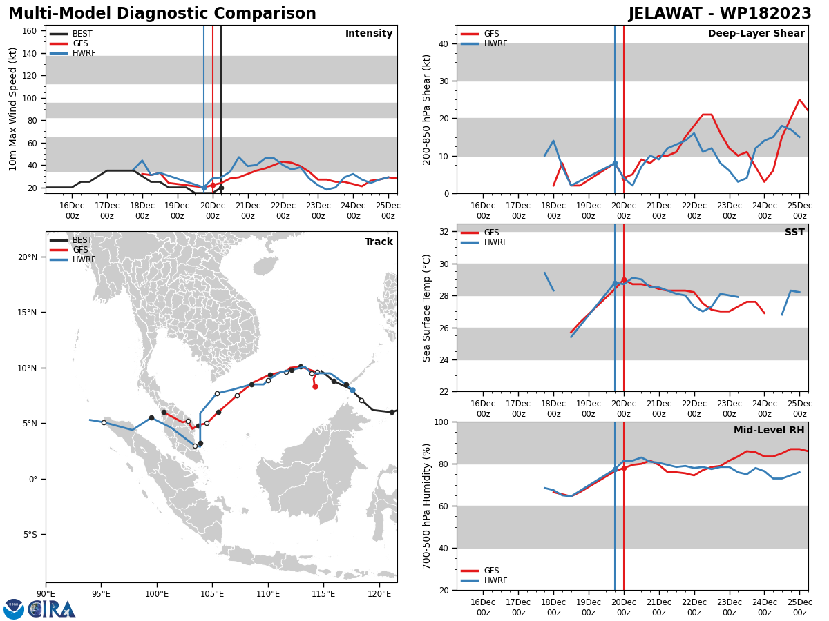
WESTERN NORTH PACIFIC: SOUTH CHINA SEA. REMNANTS OF TC 18W(JELAWAT).

AN AREA OF CONVECTION (REMNANTS 18W) HAS PERSISTED NEAR 9.9N 114.0E, APPROXIMATELY 510 NM SOUTHEAST OF DANANG, VIETNAM. ANIMATED ENHANCED INFRARED (EIR) SATELLITE IMAGERY AND A 201028Z SSMIS 37GHZ MICROWAVE IMAGERY DEPICT A HIGHLY ASYMMETRIC AREA OF CIRCULATION HUGGING THE EASTERN EDGE OF A ROBUST NORTHEAST COLD SURGE PUSHING SOUTHWEST ALONG THE COAST OF VIETNAM. THE EIR SHOWS AN AREA OF INTENSE CONVECTIVE ACTIVTY WITH SOME INDICATIONS OF MID-LEVEL ROTATION, WHICH HAS PERSISTED OVER THE PAST SIX HOURS, BUT IS NOW BEGINNING TO WEAKEN. EXPOSED LOW-LEVEL CLOUD LINES TO THE WEST AND SOUTH AS WELL AS SURFACE OBSERVATIONS FROM ACROSS THE REGION MARK THE OUTLINES OF THE RELATIVELY BROAD LOW LEVEL CIRCULATION CENTER (LLCC). THE MICROWAVE IMAGE NOTED ABOVE SHOWS A BROAD ARC OF CYCLONICALLY CURVED CONVECTION ACROSS THE NORTHERN HEMISPHERE AND AN EXPOSED LOW EMISSIVITY REGION TO THE SOUTH, GENERALLY MARKING THE POSITION OF THE LLCC. THE WIND FIELD REMAINS HIGHLY ASYMMETRIC, WITH GALE FORCE WINDS STREAMING DOWN THE FAR WESTERN EDGE OF THE CIRCULATION, WHILE ON THE EASTERN SIDE THE WINDS REMAIN PREDOMINANTLY LESS THAN 15 KNOTS. ENVIRONMENTAL ANALYSIS INDICATES MARGINAL CONDITIONS FOR DEVELOPMENT WITH GENERALLY FAVORABLE SHEAR, OUTFLOW AND SST CONDITIONS BEING OFFSET BY THE ASYMMETRIC NATURE OF THE CIRCULATION AND THE PRESENCE OF RELATIVELY STABLE AIR ASSOCIATED WITH THE COLD SURGE ENTRENCHED ACROSS THE WESTERN HALF OF THE SYSTEM. GLOBAL MODEL FIELDS SUGGEST THE SYSTEM WILL SHORTLY BEGIN DIVING SOUTHWESTWARD, RIDING THE EASTERN SIDE OF THE SURGE FLOW. BOTH THE GFS AND ECMWF MODELS SHOW SOME OF THE SURGE FLOW STARTING TO WRAP INTO THE CIRCULATION AS IT PASSES THE SOUTHERN TIP OF VIETNAM, WHICH BEARS CLOSE SCRUTINY AS THE TERRAIN INDUCED CYCLONIC FLOW ENHANCEMENT COULD RESULT IN A RAPID INCREASE IN CYCLONIC VORTICITY IN AND AROUND THE LLCC AS THE CIRCULATION APPROACHES THE SOUTHERN MALAY PENINSULA. MAXIMUM SUSTAINED SURFACE WINDS ARE ESTIMATED AT 18 TO 22 KNOTS. MINIMUM SEA LEVEL PRESSURE IS ESTIMATED TO BE NEAR 1005 MB. THE POTENTIAL FOR THE DEVELOPMENT OF A SIGNIFICANT TROPICAL CYCLONE WITHIN THE NEXT 24 HOURS IS UPGRADED TO LOW.
SOUTHERN HEMIPSHERE: SOUTH PACIFIC.INVEST 94P.
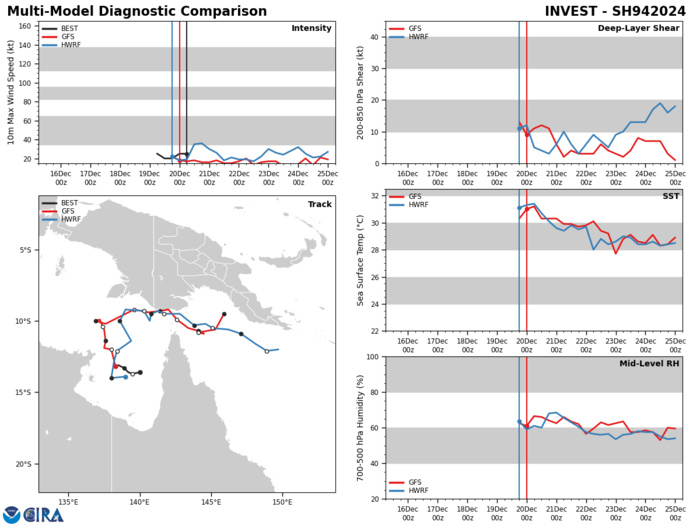
THE AREA OF CONVECTION (INVEST 94P) PREVIOUSLY LOCATED NEAR 13.3S 138.9E IS NOW LOCATED NEAR 13.1S 138.8E, APPROXIMATELY 183 NM EAST OF WEIPA. ANIMATED MULTISPECTRAL SATELLITE IMAGERY DEPICTS FLARING, DISORGANIZED CONVECTION SCATTERED OVER AN ELONGATED AREA OF LOW-LEVEL ROTATION EVIDENT IN A 200024Z ASCAT-B IMAGE. LOW-LEVEL TROUGHING EXTENDS FROM THE NORTHEAST TO THE SOUTHWEST, THROUGH THE LLCC THAT DEFINES 94P. ENVIRONMENTAL ANALYSIS INDICATES FAVORABLE CONDITIONS FOR INTENSIFICATION WITH LOW (10-15KT) VWS, GOOD UPPER- LEVEL OUTFLOW, AND WARM (30-31C) SEA SURFACE TEMPERATURES. GLOBAL MODELS ARE IN AGREEMENT THAT 94P WILL LIKELY CONTINUE TO DEVELOP AS IT CURVES EQUATORWARD AND EASTWARD OVER THE NEXT THREE DAYS. MAXIMUM SUSTAINED SURFACE WINDS ARE ESTIMATED AT 20 TO 25 KNOTS. MINIMUM SEA LEVEL PRESSURE IS ESTIMATED TO BE NEAR 1002 MB. THE POTENTIAL FOR THE DEVELOPMENT OF A SIGNIFICANT TROPICAL CYCLONE WITHIN THE NEXT 24 HOURS IS LOW.
Last Updated - 12/19/23
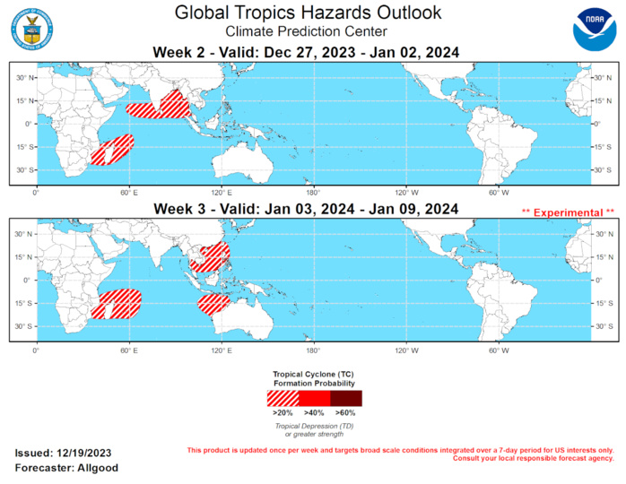
The Madden-Julian Oscillation (MJO) remains active, with the CPC upper-level velocity potential index depicting a robust signal crossing the Pacific. Recent zonal wind and outgoing longwave radiation (OLR) observations are broadly consistent with MJO activity, though easterly anomalies aloft across the equatorial Pacific are more consistent with the ongoing El Nino response. The MJO is currently constructively interfering with the ENSO signal, which is resulting in the development of a new strong westerly wind burst (WWB) centered across the equator near the Date Line. The WWB should help reinforce the ongoing El Nino conditions by attenuating the upwelling phase of the oceanic Kelvin wave generated by the previous strong WWB in November. Robust MJO activity persisting through a fairly strong ENSO pattern is somewhat unusual, and may be due in part to continued above-normal sea-surface temperatures (SSTs) in the West Pacific Warm Pool region despite a decrease in subsurface oceanic heat, which is allowing a strong convective response to the intraseasonal signal over the far western Pacific. Additionally, the MJO has begun to weaken the atmospheric response to the positive Indian Ocean Dipole (+IOD) regime, weakening the low-level easterlies across the central Indian Ocean and shifting the overall pattern eastward. Dynamical model MJO index forecasts generally depict a continuation of the MJO signal over the next four weeks, with the enhanced convective phase crossing the Western Hemisphere during Week-1, the Indian Ocean during Week-2, and the Maritime Continent during Week-3. Some models bring the signal back to the West Pacific by Week-4. Based on the previously observed ability of the intraseasonal signal to remain active despite the ENSO signal and the weakening +IOD response, the MJO is favored to remain a substantial influencer of the overall tropical convective pattern in addition to the ongoing El Nino. In particular, the MJO is favored to contribute to widespread enhanced convection across the central Indian Ocean during the outlook period, with an increased potential for tropical cyclogenesis over various Indian Ocean basins. During the past week, Tropical Storm Jelawat formed just east of the Philippines on 17 December. The remnants of this system are currently over the South China Sea north of Borneo, and are not favored to substantially redevelop. During the Week-2 period, with the MJO favored to return to the Indian Ocean, tropical cyclone development is possible over the Indian Ocean in both hemispheres. Dynamical model forecasts show a formation potential in the vicinity of Madagascar and Le Reunion Island southwestward across the Mozambique Channel, with the potential extending into early Week-3. Tropical cyclone development is also possible across the northern Indian Ocean, most likely over the Bay of Bengal, though model forecasts also depict a low-latitude formation potential in the Arabian Sea. As the MJO progresses to the Maritime Continent during Week-3, the favorable regions for tropical cyclone development also shift eastward. Despite the ENSO-driven suppression over the Maritime Continent, dynamical model forecasts indicate that the MJO enhanced phase may promote tropical cyclone development north of Australia’s Kimberley Coast. Development is also possible across the South China Sea.
