
: category 1 US and Invest 93P: updates at 16/06UTC")
 intensifying rapidly, South Pacific: Invest 90P: HIGH")


 is forecast to intensify quickly next 48h")
: CAT 1 US and intensifying and TC 23P(GRETEL): updates at 15/09UTC")
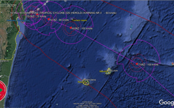
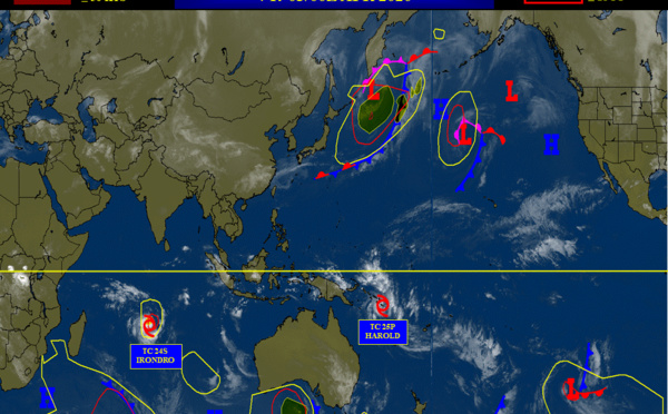
 intensifying ,TC 25P(HAROLD) intensifying rapidly. Updates at 04/03UTC")

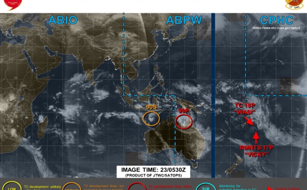
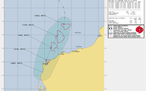
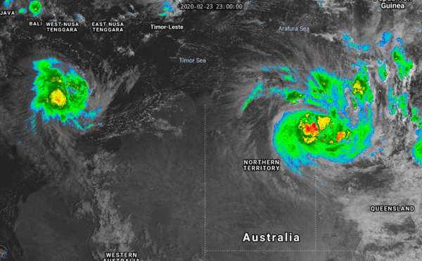
 , Invest 99P and Invest 90S: updates at 23/06UTC")


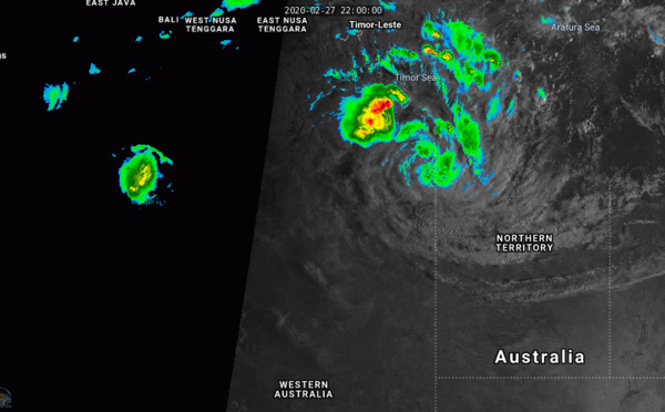
: moving inland over northern Australia. TC 20S(FERDINAND): intensifying")

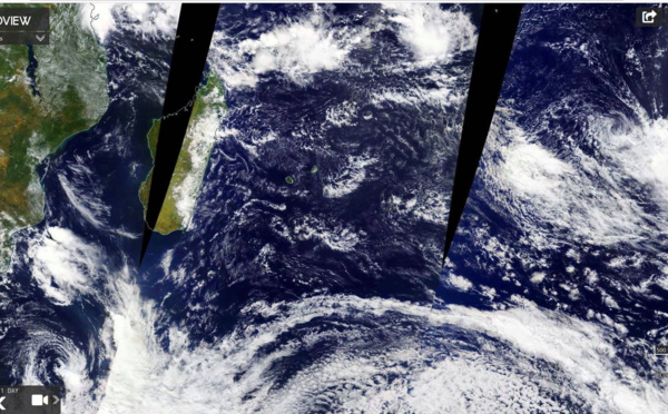
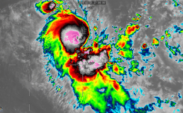
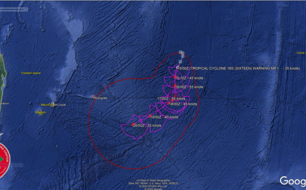
 has formed in the middle of the South Indian Ocean. Update at 15/03UTC")
: CAT 1 US weakening rapidly. 19P(ESTHER): Tropical Cyclone Formation Alert")

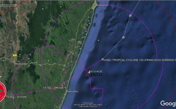
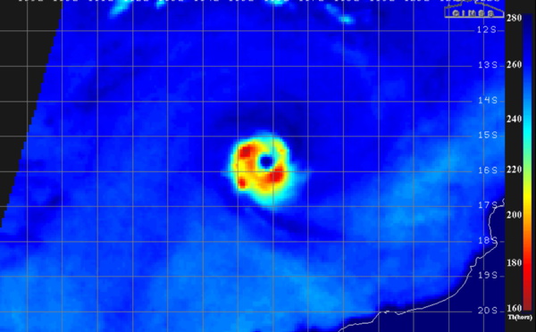
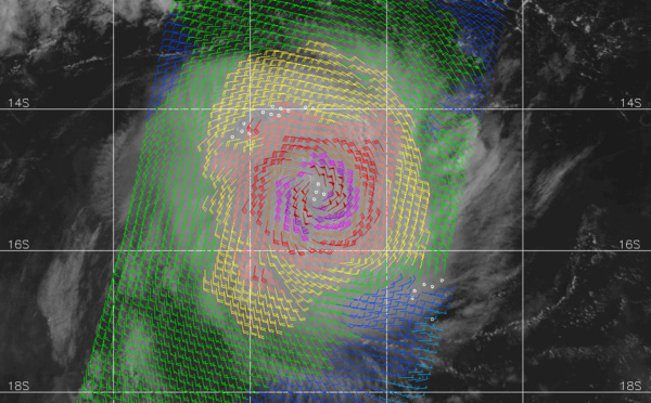
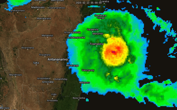
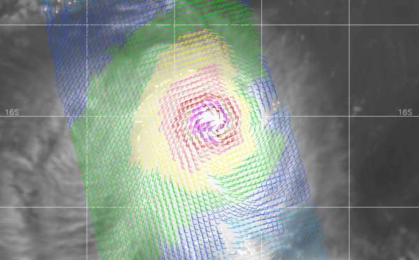
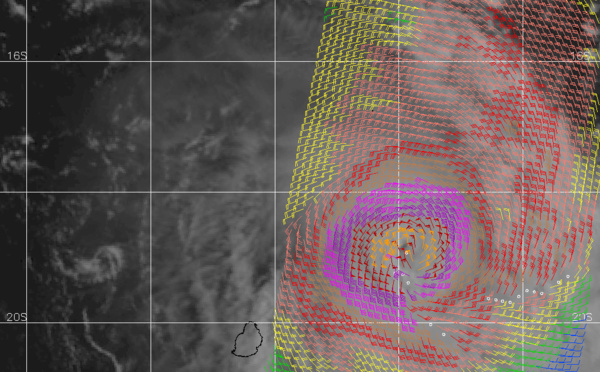
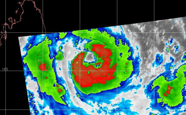
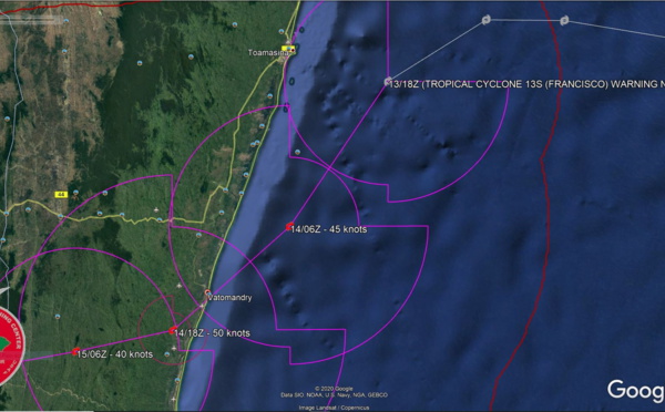
 close to landfall near Vatomandry, 94S: Tropcial Cyclone Formation Alert")
: weakening and slow-moving and Invest 93P: updates at 17/06UTC")


 and over-land TC 19P(ESTHER): 28/02 09UTC Update")
: has commenced subtropical transition")

: reduced to a 35knots TC, 93P & 96P updates at 18/06UTC")

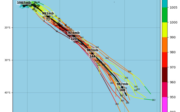
 intensifying ,TC 25P(HAROLD): potential direct threat to Vanuatu")
: CAT 2 US near peak intensity. Over-land TC 19P(ESTHER): 26/03UTC update")
: CAT 1 US and intensifying. 19P(ESTHER): over-land, 25/03UTC update")
, 13S(FRANCISCO) and 94S updates at 13/12UTC")
: CAT 2 US but expected to weaken rapidly from now on. 19P: 26/21UTC update")
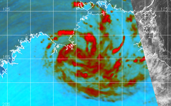
: CAT 3 US, tracking rapidly to the west of Rodrigues while weakening")
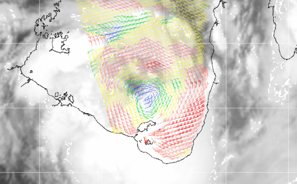
: intensifying to CAT3 US within 24h, TC 23P(GRETEL): beginning ET transition")
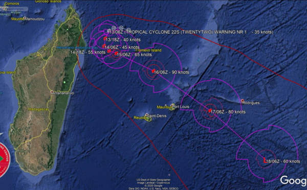
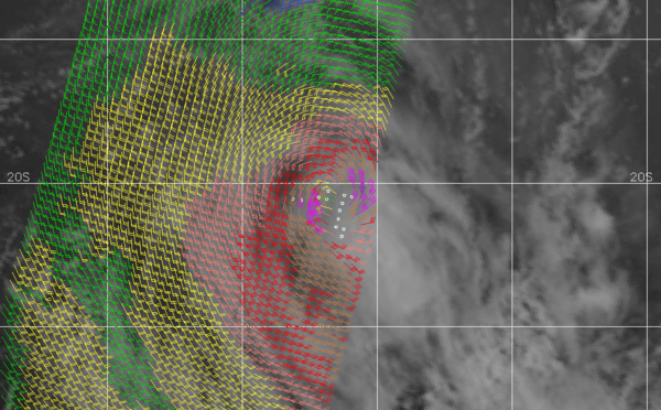
 intensifying near Madagascar, 15P(UESI) and 94S updates at 14/00UTC")


Les News
WESTERN PACIFIC: TY 12W(DOLPHIN) CAT 4 US, an ERC momentarily stopped a stunning ERI event of 80kt/24h,CAT 5 forecast within 24h/EASTERN PACIFIC: HU 07E(GENEVIEVE) still powerful//29@1130 UTC
07/29/2026
- PATRICK HOAREAU
WESTERN PACIFIC: TS 12W(DOLPHIN) forecast to reach Typhoon Intensity within 24 hours and be a Super Typhoon by 60 hours/EASTERN PACIFIC: Hurricane 07E(GENEVIEVE) Extreme Rapid Intensification from CAT 1 US to CAT 5 in 24 hours/27@1630 UTC
07/27/2026
- PATRICK HOAREAU
WESTERN PACIFIC: Typhoon 11W(NOUL) CAT 2 US making landfall East of HONG KONG/HU 06E(FAUSTO) CAT 2 /TS 07E(GENEVIEVE) forecast to peak at CAT 4 by 48 hours/Invest 93B//25@2130 UTC
07/26/2026
- PATRICK HOAREAU
WESTERN PACIFIC: Typhoon 11W(NOUL) forecast to peak at CAT 2 US while making landfall East of HONG KONG within 12 hours/EASTERN PACIFIC: HU 06E(FAUSTO) peaks at CAT2 US/07E(GENEVIEVE) set to reach CAT 3 US by 48 hours//25@1100 UTC
07/25/2026
- PATRICK HOAREAU
WESTERN PACIFIC: 11W set to gradually intensify next 2 days/EASTERN PACIFIC: 06E(FAUSTO) CAT 1 US/ATLANTIC: 02L(BERTHA)//23@1000 UTC
07/23/2026
- PATRICK HOAREAU
TROPICAL CYCLONE UPDATES PACIFIC/INDIAN/ATLANTIC OCEANS//21@1600 UTC
07/21/2026
- PATRICK HOAREAU

Liens utiles
WESTERN PACIFIC: TS 12W(DOLPHIN) forecast to reach Typhoon Intensity within 24 hours and be a Super Typhoon by 60 hours/EASTERN PACIFIC: Hurricane 07E(GENEVIEVE) Extreme Rapid Intensification from CAT 1 US to CAT 5 in 24 hours/27@1630 UTC
WESTERN PACIFIC: Typhoon 11W(NOUL) CAT 2 US making landfall East of HONG KONG/HU 06E(FAUSTO) CAT 2 /TS 07E(GENEVIEVE) forecast to peak at CAT 4 by 48 hours/Invest 93B//25@2130 UTC
WESTERN PACIFIC: Typhoon 11W(NOUL) forecast to peak at CAT 2 US while making landfall East of HONG KONG within 12 hours/EASTERN PACIFIC: HU 06E(FAUSTO) peaks at CAT2 US/07E(GENEVIEVE) set to reach CAT 3 US by 48 hours//25@1100 UTC
WESTERN PACIFIC: 11W set to gradually intensify next 2 days/EASTERN PACIFIC: 06E(FAUSTO) CAT 1 US/ATLANTIC: 02L(BERTHA)//23@1000 UTC
TROPICAL CYCLONE UPDATES PACIFIC/INDIAN/ATLANTIC OCEANS//21@1600 UTC
S'identifier