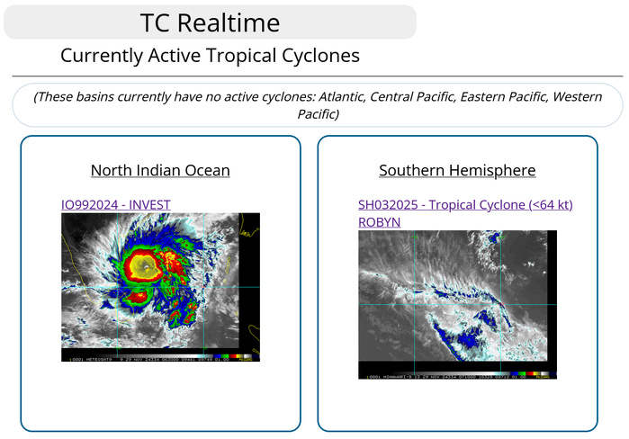
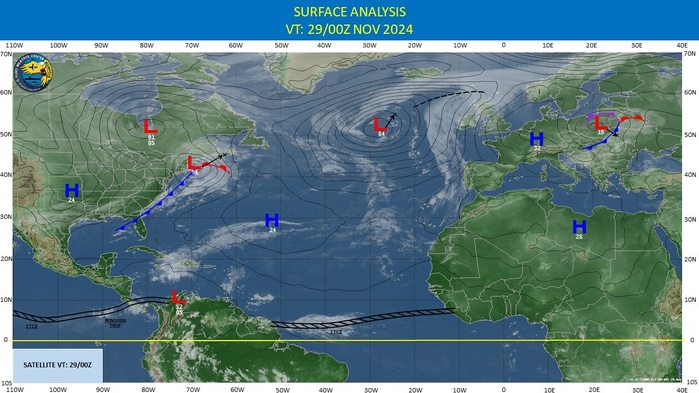
CLICK ON THE IMAGERIES BELOW TO GET THEM ENLARGED
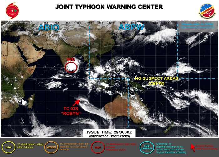
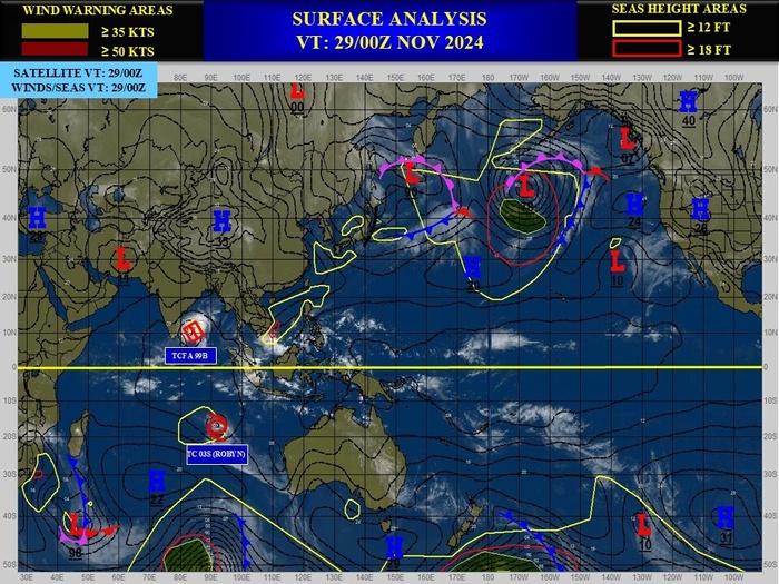
JTWC IS ISSUING 12HOURLY WARNINGS AND 3HOURLY SATELLITE BULLETINS ON 03S(ROBYN) AND 3HOURLY SATELLITE BULLETINS ON 99B.
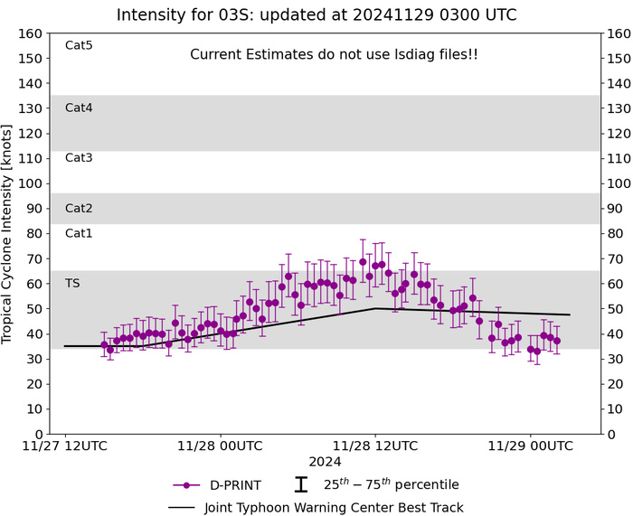
SOUTHERN HEMISPHERE/SOUTH INDIAN OCEAN: TC 03S(ROBYN). 29/06UTC ESTIMATED INTENSITY IS 40 KNOTS: - 5 KNOTS OVER 24 HOURS.PEAK INTENSITY WAS 55 KNOTS
0324112500 85S 945E 20
0324112506 88S 950E 25
0324112512 91S 953E 25
0324112518 93S 949E 25
0324112600 93S 946E 30
0324112606 93S 941E 30
0324112612 97S 935E 30
0324112618 108S 926E 30
0324112700 118S 921E 30
0324112706 122S 917E 30
0324112712 129S 913E 35
0324112718 135S 908E 35
0324112800 146S 903E 40
0324112806 154S 908E 45
0324112818 168S 919E 55
0324112900 174S 925E 50
0324112906 179S 937E 40
WARNING 4 ISSUED AT 29/03UTC
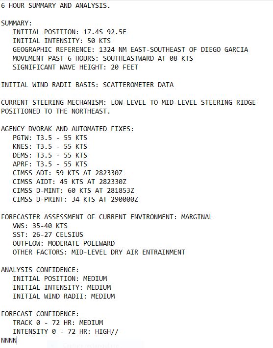
CLICK ON THE IMAGERY BELOW TO GET IT ANIMATED AND ENLARGED
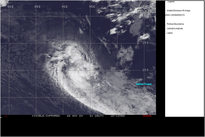
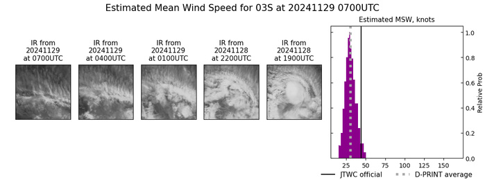
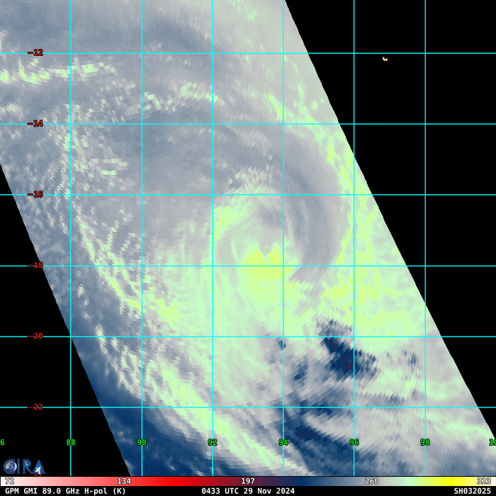
SATELLITE ANALYSIS, INITIAL POSITION AND INTENSITY DISCUSSION: TROPICAL CYCLONE 03S PEAKED AT 55 KNOTS NEAR 281500Z AS EVIDENCED BY A 281516Z ASCAT-C UHR IMAGE SHOWING 50-55 KNOTS OVER THE NORTHERN SEMICIRCLE. OVER THE PAST SIX HOURS, ANIMATED ENHANCED INFRARED (EIR) SATELLITE IMAGERY REVEALS RAPID WEAKENING DUE TO STRONG VERTICAL WIND SHEAR AND SIGNIFICANT MID-LEVEL DRY AIR ENTRAINMENT. A 282352Z WSF-M 89GHZ COLOR COMPOSITE MICROWAVE IMAGE SHOWS ISOLATED DEEP CONVECTION SHEARED 160NM SOUTHEAST OF THE CENTER, WITH SHALLOW BANDING WRAPPING TIGHTLY INTO A DEFINED LOW-LEVEL CIRCULATION CENTER. THE INITIAL POSITION IS PLACED WITH MEDIUM CONFIDENCE BASED ON THE WSF-M IMAGE. THE INITIAL INTENSITY OF 50 KTS IS ASSESSED WITH MEDIUM CONFIDENCE BASED ON A BLEND OF DVORAK FINAL-T ESTIMATES RANGING FROM T2.0-2.5 (30-35 KNOTS) AND THE MORE CONSERVATIVE CURRENT INTENSITY ESTIMATES OF 3.5 (SEE BELOW).
TC Warning Graphic
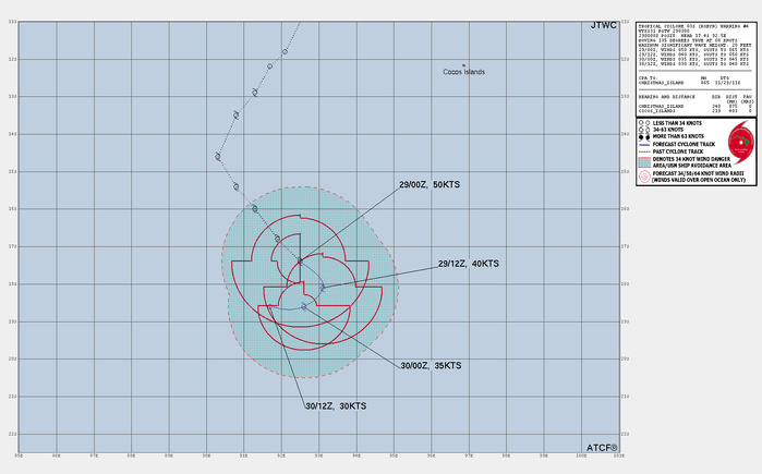
FORECAST REASONING. SIGNIFICANT FORECAST CHANGES: THERE ARE NO SIGNIFICANT CHANGES TO THE FORECAST FROM THE PREVIOUS WARNING. FORECAST DISCUSSION: TROPICAL CYCLONE (TC) 03S IS EXPECTED TO RAPIDLY WEAKEN THROUGH THE FORECAST PERIOD UNDER STRONG NORTHWESTERLY VERTICAL WIND SHEAR (VWS) AND SIGNIFICANT DRY AIR ENTRAINMENT. THE SYSTEM WILL CONTINUE TRACKING GENERALLY SOUTHEASTWARD THROUGH TAU 12 ALONG THE SOUTHWEST PERIPHERY OF A LOW-LEVEL TO MID-LEVEL STEERING RIDGE. AS 03S WEAKENS AND BECOMES SHALLOWER, IT WILL SLOW AND TURN WESTWARD UNDER THE STEERING INFLUENCE OF A LOW-LEVEL HIGH TO THE SOUTH, WITH DISSIPATION ANTICIPATED BY TAU 36 DUE TO EXTENSIVE DRY AIR AND STRONG VWS.
Model Diagnostic Plot
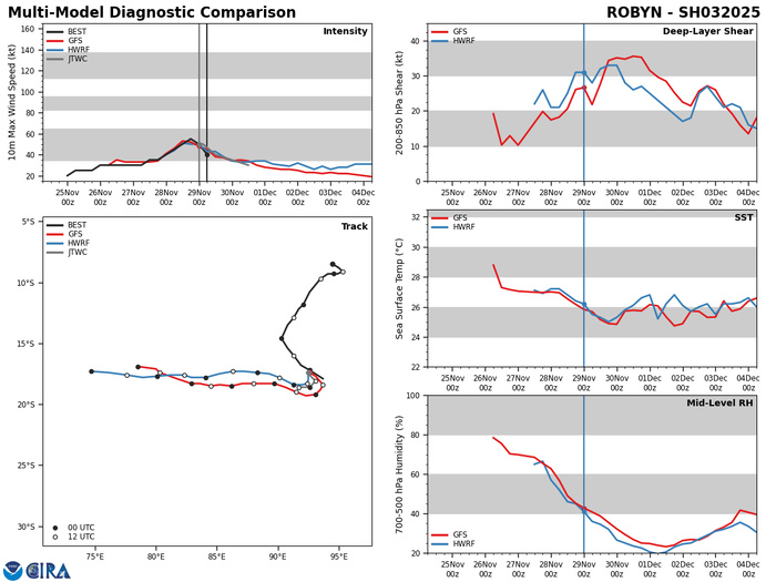
MODEL DISCUSSION: ALTHOUGH THERE IS SOME UNCERTAINTY IN THE TIMING OF THE SHARP WESTWARD TURN, DETERMINISTIC MODEL GUIDANCE REMAINS IN FAIR AGREEMENT WITH A 90NM CROSS-TRACK SPREAD IN SOLUTIONS AT TAU 36. ADDITIONALLY, THE GEFS AND EPS ENSEMBLES SUPPORT THE JTWC TRACK AND INTENSITY FORECAST WITH MEDIUM CONFIDENCE.
11/28/0737UTC MICROWAVE SIGNATURE NEAR PEAK INTENSITY
29/0530UTC SATELLITE ANALYSIS
TPXS11 PGTW 290606
A. TROPICAL CYCLONE 03S (ROBYN)
B. 29/0530Z
C. 17.12S
D. 93.42E
E. THREE/GK2A
F. T2.0/3.0/W1.0/24HRS STT: S0.0/03HRS
G. IR/EIR/VIS/MSI
H. REMARKS: 19A/PBO XPSD LLCC/ANMTN. THIS SYSTEM IS TOO WEAK TO
CLASSIFY. MET YIELDS 2.0. PT YIELDS 1.5. DBO MET.
I. ADDITIONAL POSITIONS: NONE
SWANSON
A. TROPICAL CYCLONE 03S (ROBYN)
B. 29/0530Z
C. 17.12S
D. 93.42E
E. THREE/GK2A
F. T2.0/3.0/W1.0/24HRS STT: S0.0/03HRS
G. IR/EIR/VIS/MSI
H. REMARKS: 19A/PBO XPSD LLCC/ANMTN. THIS SYSTEM IS TOO WEAK TO
CLASSIFY. MET YIELDS 2.0. PT YIELDS 1.5. DBO MET.
I. ADDITIONAL POSITIONS: NONE
SWANSON
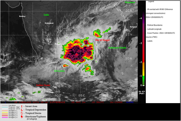
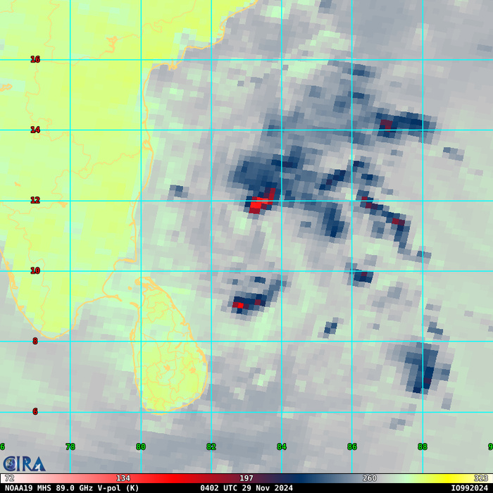
NORTH INDIAN OCEA/BAY OF BENGAL: INVEST 99B. CLICK ON THE IMAGERY BELOW TO GET IT ANIMATED AND ENLARGED
9924112112 32N 944E 15
9924112118 38N 943E 15
9924112200 43N 940E 15
9924112206 41N 930E 15
9924112212 42N 926E 15
9924112218 43N 923E 20
9924112300 44N 915E 20
9924112306 48N 902E 15
9924112312 44N 892E 20
9924112318 38N 882E 20
9924112400 37N 871E 25
9924112406 38N 865E 25
9924112412 39N 857E 25
9924112418 41N 847E 25
9924112500 43N 839E 25
9924112506 45N 833E 30
9924112512 50N 834E 30
9924112518 57N 832E 30
9924112600 60N 828E 30
9924112606 70N 830E 30
9924112612 75N 827E 30
9924112618 81N 827E 30
9924112700 83N 823E 30
9924112706 86N 823E 30
9924112712 86N 824E 30
9924112718 88N 830E 30
9924112800 89N 834E 25
9924112806 91N 838E 30
9924112812 96N 840E 30
9924112818 102N 840E 30
9924112900 103N 833E 30
9924112906 112N 826E 30
TROPICAL CYCLONE FORMATION ALERT RE-ISSUED AT 28/20UTC
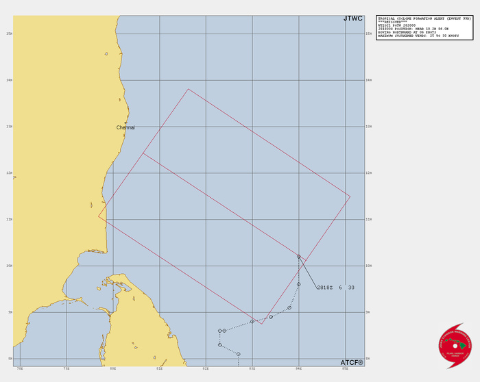
THE AREA OF CONVECTION (INVEST 99B) PREVIOUSLY LOCATED NEAR 10.1N 83.7E IS NOW LOCATED NEAR 10.2N 84.0E, APPROXIMATELY 278 NM SOUTHEAST OF CHENNAI. ANIMATED ENHANCED INFRARED (EIR) SATELLITE IMAGERY DEPICTS AN AREA OF DISORGANIZED BUT PERSISTENT CONVECTION. A 281648Z GMI 89 GHZ MICROWAVE IMAGE REVEALS FRAGMENTED CONVECTIVE BANDING THROUGHOUT THE NORTHERN SEMICIRCLE OF THE BROAD LOW-LEVEL CIRCULATION. A 281525Z ASCAT-C BULLSEYE IMAGE INDICATES AN ELONGATED CIRCULATION CENTER WITH 25-30 KT WINDS DISPLACED TO THE NORTHEAST AND SOUTHWEST OF THE DEFINED CIRCULATION. ENVIRONMENTAL ANALYSIS REVEALS A MARGINALLY FAVORABLE ENVIRONMENT FOR FURTHER DEVELOPMENT WITH GOOD UPPER-LEVEL POLEWARD OUTFLOW AND WARM SEA SURFACE TEMPERATURES OF 28- 29C OFFSET BY HIGH (30-40 KNOTS) VERTICAL WIND SHEAR (VWS). GLOBAL DETERMINISTIC MODELS ARE IN FAIR AGREEMENT THAT INVEST 99B WILL CONTINUE TO SLOWLY CONSOLIDATE AS IT TRACKS POLEWARD TOWARD THE EAST COAST OF INDIA OVER THE NEXT 24-48 HRS. MAXIMUM SUSTAINED SURFACE WINDS ARE ESTIMATED AT 25 TO 30 KNOTS. MINIMUM SEA LEVEL PRESSURE IS ESTIMATED TO BE NEAR 998 MB. THE POTENTIAL FOR THE DEVELOPMENT OF A SIGNIFICANT TROPICAL CYCLONE WITHIN THE NEXT 24 HOURS REMAINS HIGH.
Model Diagnostic Plot
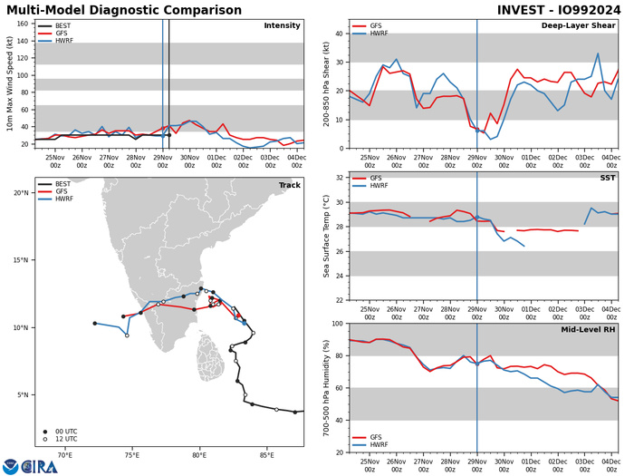
GLOBAL DETERMINISTIC MODELS ARE IN FAIR AGREEMENT THAT INVEST 99B WILL CONTINUE TO SLOWLY CONSOLIDATE AS IT TRACKS POLEWARD TOWARD THE EAST COAST OF INDIA OVER THE NEXT 24-48 HRS.
29/0530UTC SATELLITE ANALYSIS
TPIO10 PGTW 290615
A. TROPICAL DISTURBANCE 99B (NE OF SRI LANKA)
B. 29/0530Z
C. 10.97N
D. 82.73E
E. FIVE/MET9
F. T2.0/2.5/S0.0/24HRS STT: S0.0/03HRS
G. IR/EIR/VIS/MSI
H. REMARKS: 40A/PBO SBC/ANMTN. CNVCTN WRAPS .3 ON LOG10 SPIRAL
YIELDING A DT OF 2.0. MET YIELDS 3.0. PT YIELDS 2.5. DBO DT.
I. ADDITIONAL POSITIONS:
29/0423Z 11.45N 82.80E GPMI
SWANSON
Last Updated - 11/26/24 3 WEEK TROPICAL CYCLONE FORMATION PROBABILITY
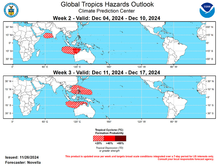
GTH Outlook Discussion Last Updated - 11/26/24 Valid - 12/04/24 - 12/17/24 Since becoming briefly disorganized over the Western Hemisphere earlier this month, both RMM and upper-level velocity potential anomaly observations show the MJO regaining amplitude with the enhanced phase propagating eastward over the Indian Ocean during the past week. Notably, the strengthening of the suppressed MJO envelope over the Pacific not only led to a break in Tropical Cyclone (TC) activity in the western Pacific basin, but also contributed to a broadening of anomalous lower-level easterlies along the equator (approximately from 120E to 120W), where an enhanced trade regime may help to enliven a La Nina base state later this year and into 2025. Looking ahead, there is good agreement in the dynamical models favoring continued eastward propagation of the MJO into and across the Maritime Continent, but there are some discrepancies in the guidance in regards to the evolution and coherence of subseasonal activity as the enhanced phase nears the Western Pacific later in December. Upper-level velocity potential anomaly forecasts depict the pattern becoming more disorganized by early December, with a low frequency response taking shape over the Maritime Continent. Similarly, lower-level zonal wind forecasts feature more persistent anomalies, suggestive of the Maritime Continent Barrier effect. However, a more progressive westerly phase of the MJO favored aloft in the models may advect less diffluent background flow, and help maintain the passage of the MJO into the Western Pacific. This realization is supported in the RMM forecasts with more ensemble members in recent runs crossing the Western Pacific, with the GEFS depicting several robust members in RMM space. The thinking is that this is likely significant, as the GEFS has been prone to stalling the MJO over the Maritime Continent based on a recent verification study. Although the amplitude of the MJO remains somewhat a question over time, the continuation of subseasonal activity expected over the Maritime Continent and into Western Pacific brings increased chances for TC development over the eastern Indian Ocean and parts of the Western Pacific during the next several weeks. It is also worth noting that while extratropical responses typically associated with Indian Ocean MJO events predominately favor warmer than normal temperatures for much of the central and eastern CONUS during boreal autumn, there are previous instances where a faster Rossby wave response from enhanced Indian Ocean convection shifting into the Maritime Continent resulted in more amplified ridging over the western U.S. and forced a downstream trough to induce anomalously colder temperatures over the eastern U.S, which is consistent with the model guidance over North America heading into early December. No TCs formed during the past week. For week-1, models continue to agree on a Westerly Wind Burst (WWB) event in the equatorial Indian Ocean (near 90E) where twin TCs (99B and 96S) are favored to form on both sides of the equator according to the Joint Typhoon Warning Center (JTWC). For 99B that is likely to form within the next day or so, models show the disturbance slowly tracking northeastward towards eastern India, though some deterministic and ensemble solutions from the ECWMF favor the low crossing India and possibly redeveloping over the Arabian Sea by the start of week-2. While the GEFS keeps the mean low over the Bay of Bengal, 20% chances for TC formation are posted to the west of India to capture this potential. Tied to the active MJO, strongly anomalous lower-level westerlies are favored to protrude eastward into the Maritime Continent, supporting TC development over the Bay of Bengal, South China Sea and the southeastern Indian Ocean. Although probabilistic tools maintain genesis signals north of the equator, the shearing environment may be too unfavorable, and there are lesser signs for low development to support any corresponding TC shapes in the week-2 outlook. However, based on continued good support in the guidance south of the equator, 40% chances are issued for week-2 to the north of western Australia, with a broad area of 20% chances extending westward to approximately 95E. For week-3, an eastward propagating MJO from phase 5 into phase 6 historically supports TC development in western Pacific, north of Australia, with odds increasing into the South Pacific based on MJO composites for Nov-Jan. Despite a quieter climatology for TC activity in the western Pacific during December, extended range probabilistic tools show increased chances for development across the South China and Philippine Seas, as well as to the north of Australia where 20% chances are issued. Genesis signals are evident in the probabilistic tools over the South Pacific during week-3, however these signals appear too modest and varied in space to support a corresponding TC shape at this time.
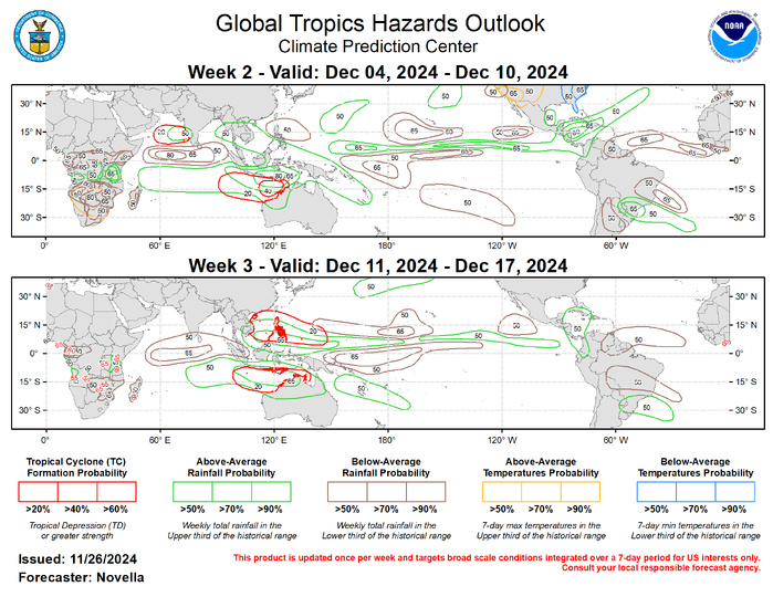
The precipitation outlook for weeks 2 and 3 is based on anticipated TC tracks, a developing La Nina base state, composites of Maritime Continent and Western Pacific MJO events, and informed by a historical skill weighted blend of GEFS, CFS, ECMWF, and Canadian precipitation guidance. For temperatures, uncalibrated and calibrated tools show increased chances for above-normal temperatures tied to early monsoon dryness over much of southern Africa. The aforementioned ridge/trough pattern favored over North America is expected to bring increased chances for above (below) normal temperature of much of the western (eastern) CONUS during week-2. For hazardous weather concerns in your area in the coming weeks, please refer to your local NWS office, the Medium Range Hazards Forecast from the Weather Prediction Center (WPC), and the CPC Week-2 Hazards Outlook. Forecasts made over Africa are made in coordination with the International Desk at CPC.
