Menu

2 WEEK CYCLONIC DEVELOPMENT POTENTIAL: North Indian and Western Pacific under watch/Invest 91B is up-graded to MEDIUM while gradually approaching Indian coastline


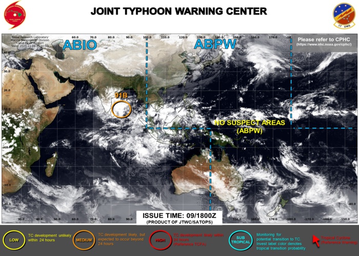
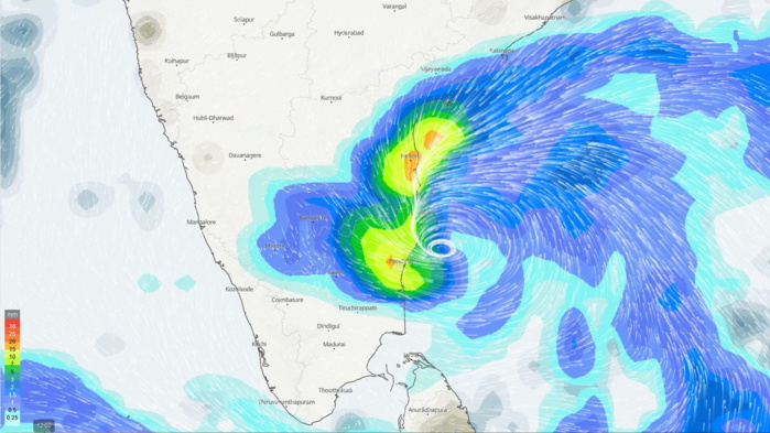
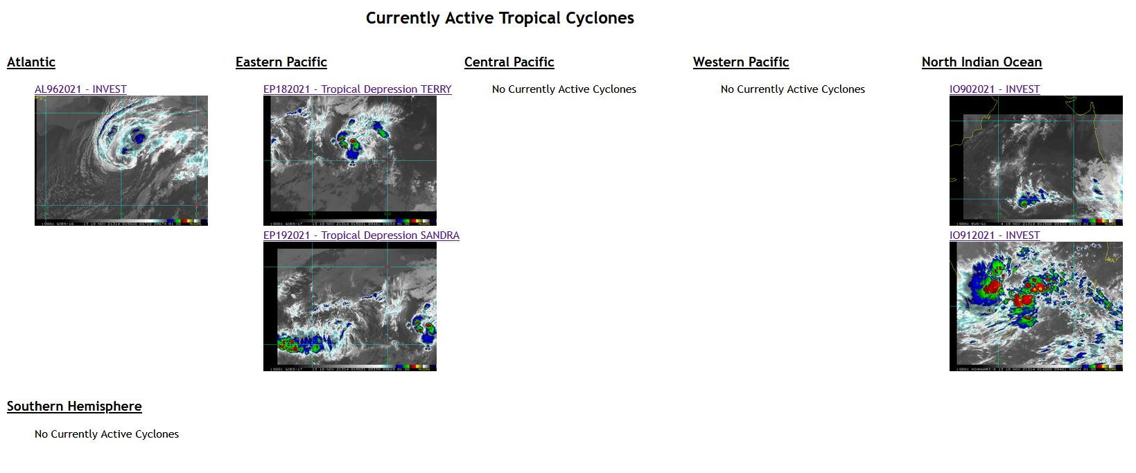
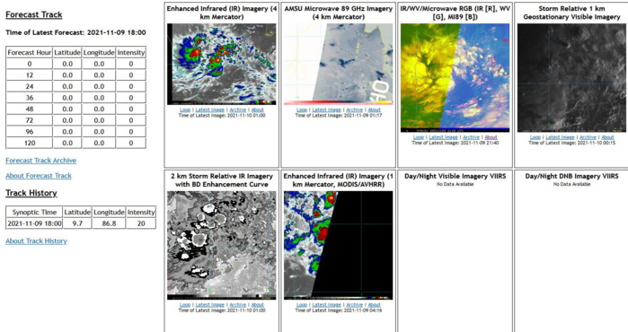
THE AREA OF CONVECTION (INVEST 91B) PREVIOUSLY LOCATED  NEAR 8.0N 89.3E IS NOW LOCATED NEAR 9.4N 87.3E, APPROXIMATELY 865 KM  EAST-SOUTHEAST OF CHENNAI, INDIA. ANIMATED ENHANCED INFRARED (EIR)  SATELLITE IMAGERY AND A 091226Z SSMIS 91 GHZ MICROWAVE IMAGE DEPICT  DISORGANIZED FORMATIVE BANDING CONVECTION WITH BROAD MID TO LOW  LEVEL TURNING AROUND A LOW LEVEL CIRCULATION (LLC). A 091424Z METOP- A ASCAT PASS SHOWS A DEFINED BUT ELONGATED SURFACE CIRCULATION.  ENVIRONMENTAL ANALYSIS INDICATES FAVORABLE CONDITIONS FOR  DEVELOPMENT WITH ROBUST EASTERLY OUTFLOW, LOW (05-10 KTS) VERTICAL  WIND SHEAR (VWS), AND WARM (29-30C) SEA SURFACE TEMPERATURES (SST).  MAXIMUM SUSTAINED SURFACE  WINDS ARE ESTIMATED AT 18 TO 23 KNOTS. MINIMUM SEA LEVEL PRESSURE IS  ESTIMATED TO BE NEAR 1007 MB. THE POTENTIAL FOR THE DEVELOPMENT OF A  SIGNIFICANT TROPICAL CYCLONE WITHIN THE NEXT 24 HOURS IS UPGRADED TO  MEDIUM.
THE AREA OF CONVECTION (INVEST 91B) PREVIOUSLY LOCATED NEAR 8.0N 89.3E IS NOW LOCATED NEAR 9.4N 87.3E, APPROXIMATELY 865 KM EAST-SOUTHEAST OF CHENNAI, INDIA. ANIMATED ENHANCED INFRARED (EIR) SATELLITE IMAGERY AND A 091226Z SSMIS 91 GHZ MICROWAVE IMAGE DEPICT DISORGANIZED FORMATIVE BANDING CONVECTION WITH BROAD MID TO LOW LEVEL TURNING AROUND A LOW LEVEL CIRCULATION (LLC). A 091424Z METOP- A ASCAT PASS SHOWS A DEFINED BUT ELONGATED SURFACE CIRCULATION. ENVIRONMENTAL ANALYSIS INDICATES FAVORABLE CONDITIONS FOR DEVELOPMENT WITH ROBUST EASTERLY OUTFLOW, LOW (05-10 KTS) VERTICAL WIND SHEAR (VWS), AND WARM (29-30C) SEA SURFACE TEMPERATURES (SST). MAXIMUM SUSTAINED SURFACE WINDS ARE ESTIMATED AT 18 TO 23 KNOTS. MINIMUM SEA LEVEL PRESSURE IS ESTIMATED TO BE NEAR 1007 MB. THE POTENTIAL FOR THE DEVELOPMENT OF A SIGNIFICANT TROPICAL CYCLONE WITHIN THE NEXT 24 HOURS IS UPGRADED TO MEDIUM.


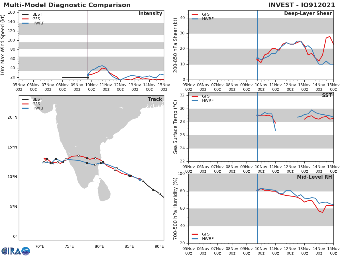
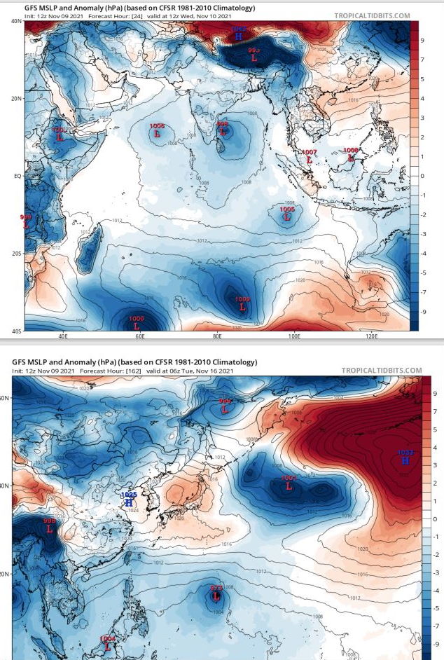
GLOBAL MODELS AGREE ON A GENERALLY NORTHWESTWARD TRACK WITH INTENSIFICATION OVER THE NEXT 48 HOURS.

_
_

GFS DEPICTS AN INTENSIFYING CIRCULATION WITH CONVECTION SHEARED TO THE WEST OF THE LOW LEVEL CIRCULATION CENTER APPROACHING PONDICHERY/CHENNAI AREA NEXT 24H.


10/0130UTC.
10/0130UTC.

WEEK 1: NOVEMBER 10 TO NOVEMBER 16

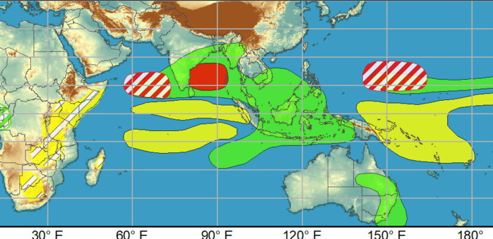
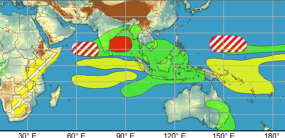
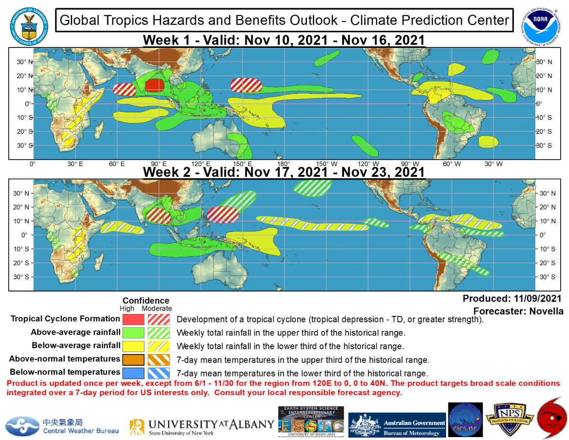
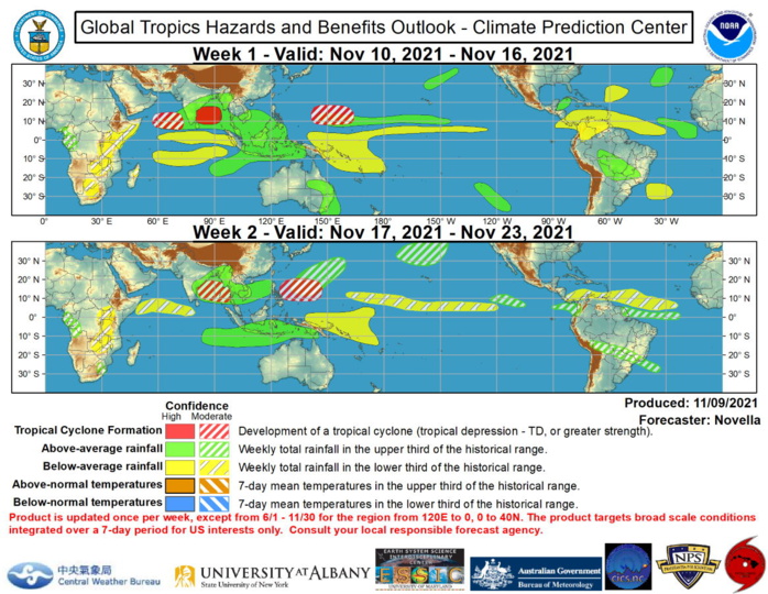
There continues to be good model support for tropical cyclogenesis in the northern Indian Ocean tied to the interaction of the aforementioned Kelvin wave and Rossby wave early in week-1. The Joint Typhoon Warning Center (JTWC) is currently monitoring a disturbance in the Bay of Bengal where reduced shear and warm SSTs remain conducive for development by the outset of the period, supporting a high confidence area in the region. Although less supported in the probabilistic tools, a moderate confidence area is also posted in the Arabian Sea associated with another area of low pressure that is favored to strengthen in the deterministic solutions later this week. Regardless of formation with these two disturbances, heavy precipitation amounts appear likely, which may trigger flooding for parts of southern India and Sri Lanka during the next several days. By early to the middle part of next week, there is continued support in the ensemble and probabilistic guidance favoring the development of another closed low in the Bay of Bengal, prompting a moderate confidence area for week-2. In the western Pacific, dynamical models continue to advertise an area of low pressure strengthening near the Mariana Islands next week, however there remains differences in regards to the timing of this feature. To address this uncertainty, a pair of moderate confidence areas are posted for week-1 and week-2, with the latter area more focused in the Philippine Sea in accordance with the ECMWF solutions. NOAA.
 Issued at 09/1830UTC by NOAA.
In collaboration with the JTWC and several well known organizations.

 Archives: HERE

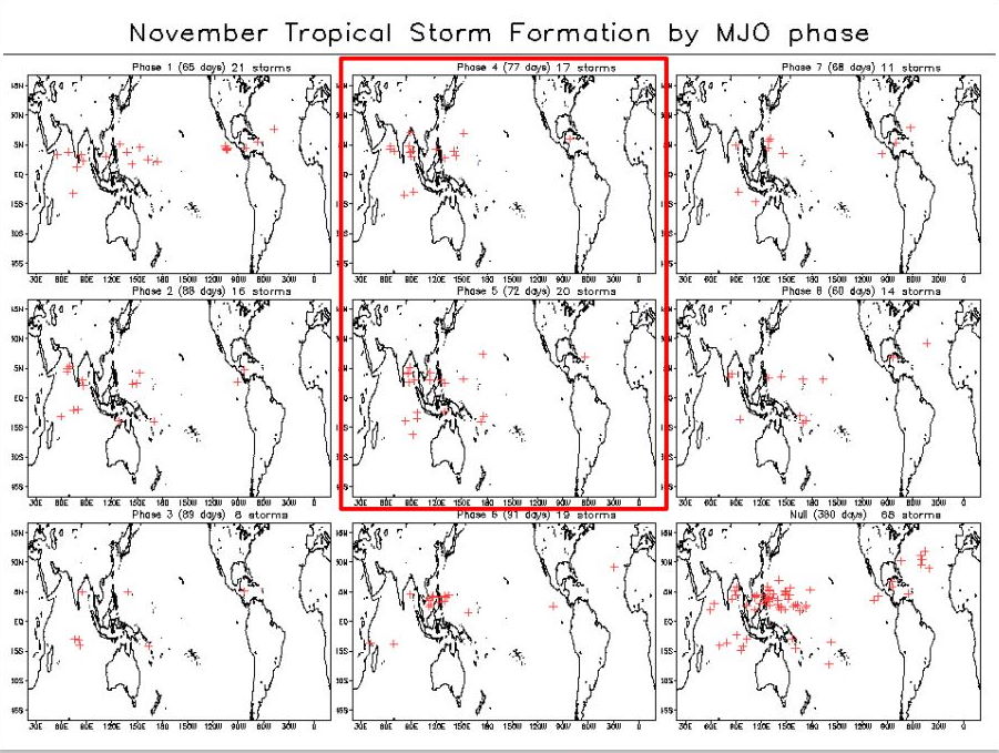
The MJO remains weak as reflected in the RMM index which has continued to show a low amplitude intraseasonal signal since mid-October. During the past week, the MJO signal rapidly shifted eastward into the Maritime Continent likely tied to the passage of a Kelvin wave, and more recently, retreated back into phase 3 likely due to Rossby wave activity that is currently analyzed over the Indian Ocean. Looking ahead, dynamical models favor the resumption of an eastward propagating signal over the Maritime Continent, but maintain a low amplitude as the majority of ensemble means keep the signal within the RMM unit circle during the next two weeks. Of note, there are several ensemble members, including statistical guidance, which favor a stronger MJO event crossing the western Pacific later in the period. However, there remains a good deal of uncertainty in this realization given the strengthening low frequency base state associated with the ongoing La Nina. The large-scale environment is expected to be conducive for tropical cyclone (TC) formation in the Eastern Hemisphere, and quieter conditions are anticipated for the eastern Pacific and Atlantic basins in conjunction with a less active climatology later in November.  A pair of TCs, Sandra and Terry, formed in the eastern Pacific and briefly peaked at Tropical Storm intensity this past weekend. Now both at tropical depression strength, the National Hurricane Center (NHC) forecasts these two systems to continue tracking westward over open waters, and eventually dissipate later this week. No TC areas are added in the outlook over the eastern Pacific, as there is little support in the guidance for additional TC development during the next two weeks. Across the Atlantic, a broad area of suppressed convection continues to be favored among the ensembles throughout the Caribbean and the Main Development Region, reducing the potential for late season TC activity during the next two weeks. Farther north, subtropical cyclone development is possible near the Azores late in week-1, however confidence is too low to include any corresponding TC shapes in the outlook given less support from probabilistic guidance and cooler sea surface temperatures (SSTs) in the region.  There continues to be good model support for tropical cyclogenesis in the northern Indian Ocean tied to the interaction of the aforementioned Kelvin wave and Rossby wave early in week-1. The Joint Typhoon Warning Center (JTWC) is currently monitoring a disturbance in the Bay of Bengal where reduced shear and warm SSTs remain conducive for development by the outset of the period, supporting a high confidence area in the region. Although less supported in the probabilistic tools, a moderate confidence area is also posted in the Arabian Sea associated with another area of low pressure that is favored to strengthen in the deterministic solutions later this week. Regardless of formation with these two disturbances, heavy precipitation amounts appear likely, which may trigger flooding for parts of southern India and Sri Lanka during the next several days. By early to the middle part of next week, there is continued support in the ensemble and probabilistic guidance favoring the development of another closed low in the Bay of Bengal, prompting a moderate confidence area for week-2. In the western Pacific, dynamical models continue to advertise an area of low pressure strengthening near the Mariana Islands next week, however there remains differences in regards to the timing of this feature. To address this uncertainty, a pair of moderate confidence areas are posted for week-1 and week-2, with the latter area more focused in the Philippine Sea in accordance with the ECMWF solutions.  The precipitation outlook during the next two weeks is based on a consensus of GEFS, CFS, and ECMWF guidance. For hazardous weather concerns during the next two weeks across the U.S., please refer to your local NWS Forecast Office, the Weather Prediction Center's Medium Range Hazards Forecast, and CPC's Week-2 Hazards Outlook. Forecasts over Africa are made in consultation with the International Desk at CPC and can represent local-scale conditions in addition to global scale variability. NOAA.
The MJO remains weak as reflected in the RMM index which has continued to show a low amplitude intraseasonal signal since mid-October. During the past week, the MJO signal rapidly shifted eastward into the Maritime Continent likely tied to the passage of a Kelvin wave, and more recently, retreated back into phase 3 likely due to Rossby wave activity that is currently analyzed over the Indian Ocean. Looking ahead, dynamical models favor the resumption of an eastward propagating signal over the Maritime Continent, but maintain a low amplitude as the majority of ensemble means keep the signal within the RMM unit circle during the next two weeks. Of note, there are several ensemble members, including statistical guidance, which favor a stronger MJO event crossing the western Pacific later in the period. However, there remains a good deal of uncertainty in this realization given the strengthening low frequency base state associated with the ongoing La Nina. The large-scale environment is expected to be conducive for tropical cyclone (TC) formation in the Eastern Hemisphere, and quieter conditions are anticipated for the eastern Pacific and Atlantic basins in conjunction with a less active climatology later in November. A pair of TCs, Sandra and Terry, formed in the eastern Pacific and briefly peaked at Tropical Storm intensity this past weekend. Now both at tropical depression strength, the National Hurricane Center (NHC) forecasts these two systems to continue tracking westward over open waters, and eventually dissipate later this week. No TC areas are added in the outlook over the eastern Pacific, as there is little support in the guidance for additional TC development during the next two weeks. Across the Atlantic, a broad area of suppressed convection continues to be favored among the ensembles throughout the Caribbean and the Main Development Region, reducing the potential for late season TC activity during the next two weeks. Farther north, subtropical cyclone development is possible near the Azores late in week-1, however confidence is too low to include any corresponding TC shapes in the outlook given less support from probabilistic guidance and cooler sea surface temperatures (SSTs) in the region. There continues to be good model support for tropical cyclogenesis in the northern Indian Ocean tied to the interaction of the aforementioned Kelvin wave and Rossby wave early in week-1. The Joint Typhoon Warning Center (JTWC) is currently monitoring a disturbance in the Bay of Bengal where reduced shear and warm SSTs remain conducive for development by the outset of the period, supporting a high confidence area in the region. Although less supported in the probabilistic tools, a moderate confidence area is also posted in the Arabian Sea associated with another area of low pressure that is favored to strengthen in the deterministic solutions later this week. Regardless of formation with these two disturbances, heavy precipitation amounts appear likely, which may trigger flooding for parts of southern India and Sri Lanka during the next several days. By early to the middle part of next week, there is continued support in the ensemble and probabilistic guidance favoring the development of another closed low in the Bay of Bengal, prompting a moderate confidence area for week-2. In the western Pacific, dynamical models continue to advertise an area of low pressure strengthening near the Mariana Islands next week, however there remains differences in regards to the timing of this feature. To address this uncertainty, a pair of moderate confidence areas are posted for week-1 and week-2, with the latter area more focused in the Philippine Sea in accordance with the ECMWF solutions. The precipitation outlook during the next two weeks is based on a consensus of GEFS, CFS, and ECMWF guidance. For hazardous weather concerns during the next two weeks across the U.S., please refer to your local NWS Forecast Office, the Weather Prediction Center's Medium Range Hazards Forecast, and CPC's Week-2 Hazards Outlook. Forecasts over Africa are made in consultation with the International Desk at CPC and can represent local-scale conditions in addition to global scale variability. NOAA.

2 WEEK CYCLONIC DEVELOPMENT POTENTIAL: North Indian and Western Pacific under watch/Invest 91B is up-graded to MEDIUM while gradually approaching Indian coastline

Rédigé par PATRICK HOAREAU le Wednesday, November 10th 2021 à 05:53