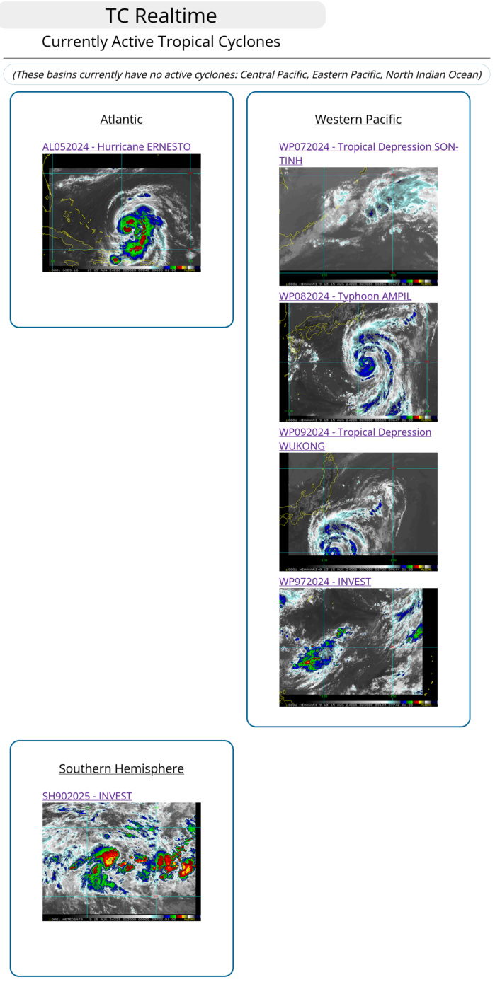
CLICK ON THE IMAGERIES BELOW TO GET THEM ENLARGED
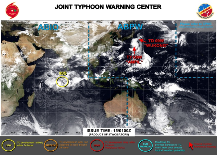
JTWC IS ISSUING 6HOURLY WARNINGS AND 3 HOURLY SATELLITE BULLETINS ON 08W. 3HOURLY SATELLITE BULLETINS ARE ISSUED ON 09W.
WESTERN NORTH PACIFIC: TY 08W(AMPIL). WARNING 3 ISSUED AT 1303UTC. ESTIMATED INTENSITY IS 85 KNOTS/CAT 2 US: +25 KNOTS OVER 24 HOURS.
0824081200 223N1359E 20
0824081206 229N1367E 35
0824081212 236N1373E 40
0824081218 243N1378E 40
0824081300 247N1382E 40
0824081306 251N1385E 45
0824081312 254N1391E 50
0824081318 256N1396E 55
0824081400 261N1403E 60
0824081406 268N1407E 65
0824081412 276N1411E 75
0824081418 284N1413E 75
0824081500 297N1412E 85
0824081206 229N1367E 35
0824081212 236N1373E 40
0824081218 243N1378E 40
0824081300 247N1382E 40
0824081306 251N1385E 45
0824081312 254N1391E 50
0824081318 256N1396E 55
0824081400 261N1403E 60
0824081406 268N1407E 65
0824081412 276N1411E 75
0824081418 284N1413E 75
0824081500 297N1412E 85
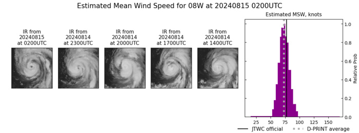
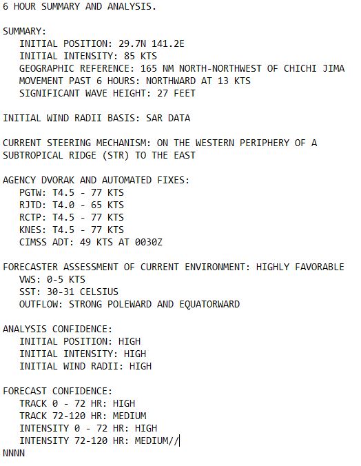
SATELLITE ANALYSIS, INITIAL POSITION AND INTENSITY DISCUSSION: ANIMATED MULTISPECTRAL SATELLITE IMAGERY (MSI) DEPICTS A BANDING EYE WITH STRONG POLEWARD AND EQUATORWARD OUTFLOW. A SLOT OF DRY AIR ATTEMPTS TO WRAP INTO THE LOW-LEVEL CIRCULATION CENTER (LLCC) FROM THE SOUTHWEST. A 142034Z RCM-3 SYNTHETIC APERTURE RADAR (SAR) IMAGE REVEALS AN EYE FEATURE WITH A STRONG BAND OF 80-85KT WINDS WRAPPING FROM THE EASTERN EDGE AROUND TO THE WESTERN SIDE OF THE SYSTEM. THE INITIAL POSITION IS PLACED WITH HIGH CONFIDENCE BASED ON THE AFOREMENTIONED MSI AND SUPPORTED BY EXTRAPOLATION FROM THE SAR IMAGE. THE INITIAL INTENSITY OF 85 KTS IS ASSESSED WITH HIGH CONFIDENCE BASED ON THE AFOREMENTIONED SAR IMAGERY ALONG WITH THE AGENCY AND OBJECTIVE FIXES LISTED BELOW.
TC Warning Graphic
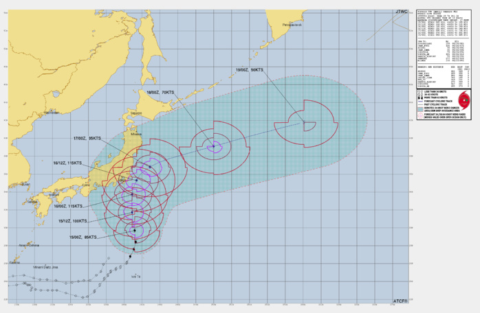
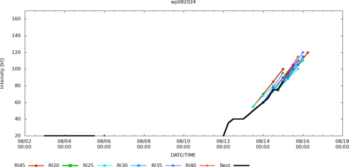
FORECAST REASONING. SIGNIFICANT FORECAST CHANGES: TYPHOON (TY) 08W IS NOW FORECAST TO UNDERGO A PERIOD OF RAPID INTENSIFICATION (RI) DURING THE FIRST 24 HOURS OF THE FORECAST TO A PEAK OF 115KTS WHICH WAS NOT REFLECTED IN THE PREVIOUS WARNING. FORECAST DISCUSSION: TY 08W IS FORECAST TO TRACK NORTHWARD THROUGH THE FIRST 24 HOURS OF THE FORECAST PERIOD BEFORE ROUNDING THE WESTERN PERIPHERY OF THE STR TO THE EAST FROM TAU 36-48. AFTER ROUNDING THE RIDGE, TY 08W WILL TRACK DUE EAST-NORTHEAST THROUGH THE REMAINDER OF THE FORECAST. RAPID INTENSIFICATION IS FORECAST TO OCCUR TO A PEAK OF 115KTS BY TAU 24 AND MAY REACH A HIGHER PEAK BETWEEN TAU 24-36 THAT IS NOT REFLECTED IN THE FORECAST WARNING. AFTER TAU 36, TY 08W WILL BECOME INFLUENCED BY MODERATE VERTICAL WIND SHEAR AND A BRIEF PERIOD OF NEGATIVE UPPER-LEVEL CONVERGENCE WHICH WILL INITIATE WEAKENING. DESPITE THE UPPER-LEVEL ENVIRONMENT IMPROVING BY TAU 48, VERTICAL WIND SHEAR WILL BECOME HIGHLY UNFAVORABLE BETWEEN TAU 48-60 AS THE SYSTEM TRACKS INTO UNFAVORABLE SEA SURFACE TEMPERATURES THAT ARE BELOW 26 DEGREES. THE COOLER SEA SURFACE TEMPERATURES AND BAROCLINIC ENVIRONMENT WILL INITIATE EXTRATROPICAL TRANSITION BETWEEN TAU 60-72, WHICH WILL LEAD TO TY 08W BECOMING FULLY EXTRATROPICAL BY TAU 96.
Model Diagnostic Plot
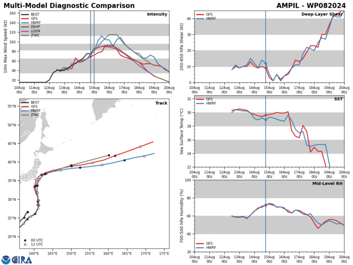
MODEL DISCUSSION: DETERMINISTIC MODEL GUIDANCE IS IN TIGHT AGREEMENT THROUGH TAU 48 WITH A MINIMUM CROSS-TRACK SPREAD OF 65NM, BUT THE ALONG-TRACK SPREAD OPENS TO 300NM BY TAU 96, WHICH LOWERS THE UNCERTAINTY IN THE TRACK FORECAST AFTER THE SYSTEM ROUNDS THE CURVE OF THE STR TO THE EAST. THE GEFS AND ECENS ENSEMBLE GUIDANCE DEPICTS SOLUTIONS FARTHER WEST AND CLOSER TO THE BOSO PENINSULA THAN CONVEYED IN THE MULTI-MODEL CONSENSUS. THE JTWC INTENSITY GUIDANCE STRONGLY INDICATES HIGHER PROBABILITY OF RAPID INTENSIFICATION WITHIN THE FIRST 24 HOURS OF THE FORECAST PARTICULARLY DUE TO THE ELEVATED SEA SURFACE TEMPERATURES BETWEEN 30-31C, STRONG UPPER-LEVEL DIVERGENCE, AND LOW VERTICAL WIND SHEAR. THE JTWC INTENSITY FORECAST LIES ABOVE THE MULTI-MODEL CONSENSUS, WHICH IS DRAWN LOWER DUE TO GFS, HAFS-A, AND COAMPS-TC.
Rapid Intensification Guidance
2024 0814 2032UTC RCM-3, STAR Synthetic Aperture Radar 3KM Wind Speed Analysis: MAXIMUM 1 MINUTE WINDS: 84 KNOTS
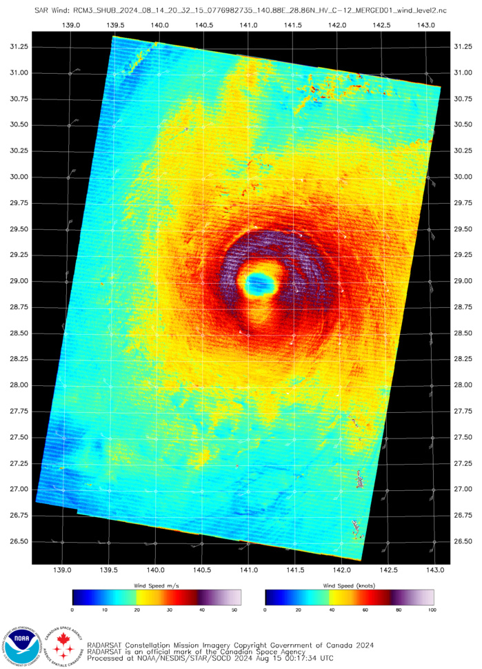
RCM-3 SYNTHETIC APERTURE RADAR (SAR) IMAGE REVEALS AN EYE FEATURE WITH A STRONG BAND OF 80-85KT WINDS WRAPPING FROM THE EASTERN EDGE AROUND TO THE WESTERN SIDE OF THE SYSTEM.
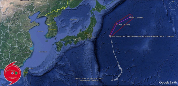
WESTERN NORTH PACIFIC: TD 09W(WUKONG). WARNING 9/FINAL ISUSED AT 1503UTC.PEAK INTENSITY WAS 30 KNOTS.
0924081112 244N1470E 15
0924081118 245N1478E 15
0924081200 247N1484E 15
0924081206 254N1489E 15
0924081212 259N1494E 20
0924081218 264N1498E 20
0924081300 270N1498E 25
0924081306 274N1496E 25
0924081312 276N1493E 30
0924081318 282N1490E 30
0924081400 291N1487E 30
0924081406 306N1480E 30
0924081412 319N1474E 30
0924081418 343N1469E 25
0924081500 360N1465E 20
SOUTHERN HEMISPHERE/SOUTH INDIAN OCEAN: INVEST 90S. ADVISORY ISSUED AT 1501UTC.
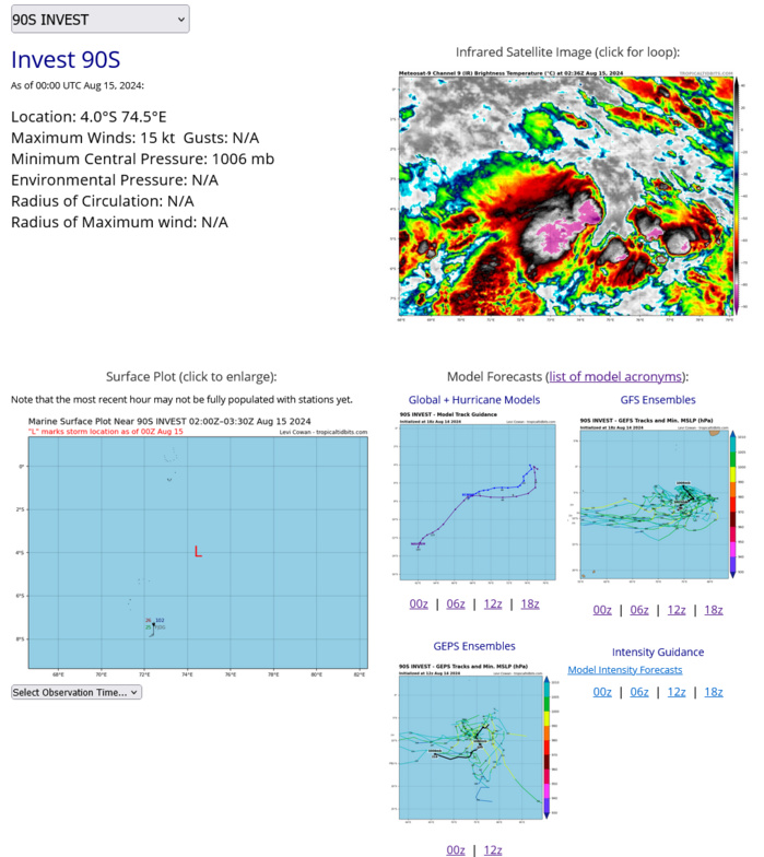
AN AREA OF CONVECTION (INVEST 90S) HAS PERSISTED NEAR 4.0S 74.5E, APPROXIMATELY 277 NM NORTHEAST OF DIEGO GARCIA. ENHANCED INFRARED SATELLITE IMAGERY AND A 142328Z GMI 89GHZ SATELLITE IMAGERY DEPICTS A PARTIALLY EXPOSED CIRCULATION WITH LOOSELY DEFINED CLOUD LINES IN THE LOW LEVELS BEGINNING TO CONSOLIDATE. ENVIRONMENTAL ANALYSIS REVEALS THAT 90S IS IN A MARGINALLY FAVORABLE ENVIRONMENT FOR DEVELOPMENT, WITH WARM SST (27-28C), HIGH VWS (>25KTS), AND GOOD UPPER LEVEL OUTFLOW. MODEL GUIDANCE IS IN GOOD AGREEMENT THAT 90S WILL CONTINUE TO TRACK WEST-SOUTHWESTWARD OVER THE NEXT 48 HOURS. MAXIMUM SUSTAINED SURFACE WINDS ARE ESTIMATED AT 13 TO 18 KNOTS. MINIMUM SEA LEVEL PRESSURE IS ESTIMATED TO BE NEAR 1006 MB. THE POTENTIAL FOR THE DEVELOPMENT OF A SIGNIFICANT TROPICAL CYCLONE WITHIN THE NEXT 24 HOURS IS LOW.
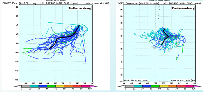
MODEL GUIDANCE IS IN GOOD AGREEMENT THAT 90S WILL CONTINUE TO TRACK WEST-SOUTHWESTWARD OVER THE NEXT 48 HOURS.
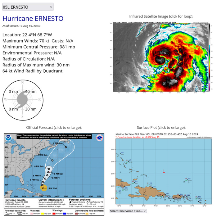
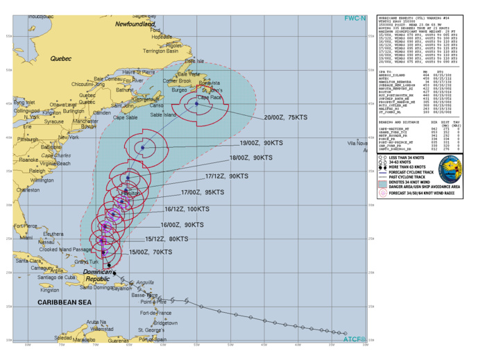
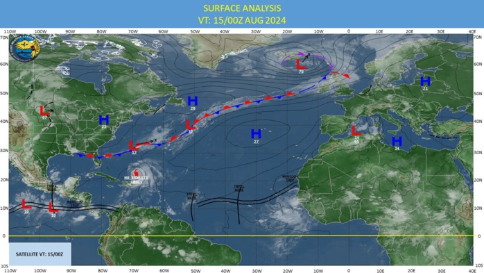
NORTH ATLANTIC: HURRICANE 05L(ERNESTO). CURRENT ESTIMATED INTENSITY IS 70 KNOTS/CAT 1 US : + 15 KNOTS OVER 24 HOURS.
0524081200 138N 492W 25
0524081206 143N 517W 25
0524081212 150N 543W 25
0524081218 158N 565W 35
0524081300 159N 586W 35
0524081306 161N 605W 35
0524081312 166N 620W 40
0524081318 176N 635W 50
0524081400 184N 647W 55
0524081406 190N 660W 60
0524081412 199N 672W 65
0524081418 211N 680W 65
0524081500 224N 687W 70
0524081206 143N 517W 25
0524081212 150N 543W 25
0524081218 158N 565W 35
0524081300 159N 586W 35
0524081306 161N 605W 35
0524081312 166N 620W 40
0524081318 176N 635W 50
0524081400 184N 647W 55
0524081406 190N 660W 60
0524081412 199N 672W 65
0524081418 211N 680W 65
0524081500 224N 687W 70
TC Warning Graphic
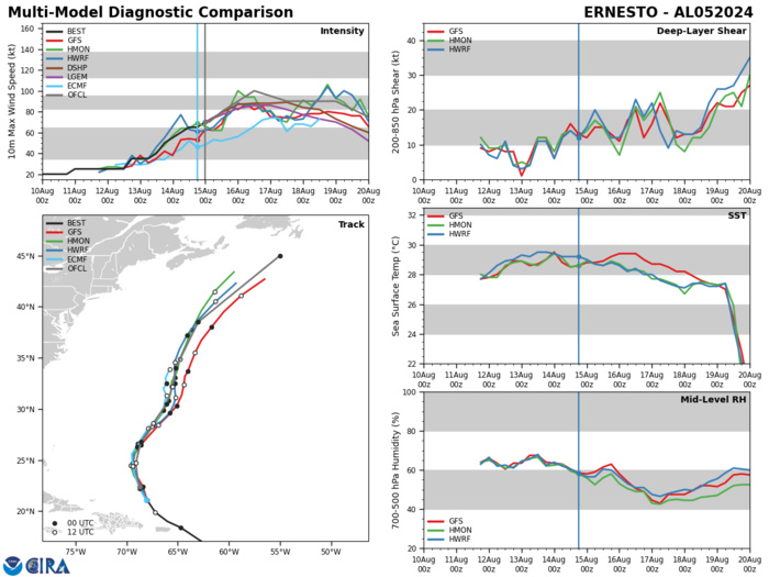
Model Diagnostic Plot
Last Updated - 08/13/24 3 WEEK TROPICAL CYCLONE FORMATION PROBABILITY
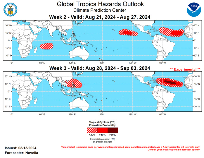
GTH Outlook Discussion Last Updated - 08/13/24 Valid - 08/21/24 - 09/03/24 As previously forecast, the RMM observations continue to show signs of renewed, eastward propagating MJO activity over the Western Hemisphere. The upper-level velocity potential pattern has been somewhat disorganized, mostly due to continued competing interference with other modes of tropical variability (namely wave-2 Kelvin wave activity), however the enhanced convective envelope appears better defined in recent days with the leading edge extending further eastward into the Indian Ocean. Looking ahead, dynamical models have been consistently advertising a robust Indian Ocean MJO event that propagates eastward into the Maritime Continent in both RMM space and in the upper-level velocity potential anomaly forecasts during the next several weeks. A canonical wave-1 pattern is favored to emerge during the next week or so, and objective wave filtering continues to favor both equatorial Kelvin and Rossby wave activity over Africa and the Indian Ocean. The constructive interference between these modes and the reorganizing MJO lead to very enhanced signals in the velocity potential anomaly fields. In the lower levels, there is good agreement in extended range solutions featuring a band of strong lower-level westerly anomalies overspreading the tropical Atlantic and extending into sub-Saharan Africa, as this later feature is suggestive a northward displaced African Easterly Jet to incite a number of easterly waves. As a result, the large-scale environment looks to be quite favorable for additional Tropical Cyclone (TC) development in the Main Development Region (MDR) in-line with an increasingly active climatology for late August and early September. Tied to the suppressed phase of the MJO downstream, an enhanced trade regime is expected to overspread the Maritime Continent and equatorial Pacific, decreasing chances for TC development in the western Pacific. During the past week, four TCs formed in the Western Pacific, and one in the Atlantic. Since forming on 8/7 near 25N/141E, TC Maria peaked at Category 1 strength while tracking northward and curving to the west toward Japan. Maria made landfall as a Tropical Storm on 8/12 over the Tohoku region of northeastern Japan, and brought high winds, and heavy rainfall accumulations leading to an increased risk of flooding and mudslides in the region. Since yesterday, TCs Son-Tinh, Wukong, and Ampil formed near 32N/151E, 26N/150E, and 23N/136E, respectively. The Joint Typhoon Warning Center (JTWC) expects Son-Tinh to be a short-lived storm but may bring increased precipitation and elevated winds as it tracks northward over parts of northern Japan in the wake of TC Maria. Wukong is similarly forecast to track northward, but is expected to curve eastward over open waters under a steering subtropical ridge later this week. Further south, TC Ampil bears watching during the next several days. While there remains a good deal of uncertainty with the eventual track of the system later this week, the official forecast from the JTWC shows this system intensifying to Category 3 strength, while tracking towards central Japan near Tokyo. Regardless of landfall, heavy precipitation accumulations and high sustained winds are possible for portions of eastern Honshu Japan. As these systems eventually dissipate in the western Pacific, it is worth noting that their extratropical transition may lead to the amplification of mid-level height pattern downstream over Alaska. In the tropical Atlantic, Tropical Storm Ernesto formed on 8/12. This system is expected to bring heavy rainfall, with possible mudslides and flash flooding for parts of the Leeward Islands, USVI and Puerto Rico in the next few days. Later this week, the National Hurricane Center (NHC) expects Ernesto to turn northward under a weakness in the subtropical ridge. While the official track places Ernesto in proximity to Bermuda by this weekend, it is too soon to know what impacts this system could bring as ensemble spread remains high in the models. Please follow the JTWC and the NHC for regular updates for these active systems. Across the Eastern Hemisphere, the band of anomalous lower-level westerlies that likely contributed to multiple TC formations north of 20N in the Western Pacific are favored to weaken and be replaced by enhanced trades overspreading much of the basin. Given this, the suppressed phase of the MJO, and lessening support in the probabilistic TC genesis tools for additional TC activity, the western Pacific looks to take a hiatus, and no shapes are posted for week-2. By week-3, guidance does show conditions becoming gradually more favorable, particularly over the South China Sea and just east of the Philippines, and 20% chances are posted for week-3. With the enhanced phase of the MJO gaining amplitude over the Indian Ocean, there is good model support for a Westerly Wind Burst (WWB) event during the next week or so between 70-80E. Despite being out of season, probabilistic tools continue to feature elevated chances for TC formation south of the equator. While such development would be extremely rare, it is not unprecedented according to August climatology, and 20% chances are posted from approximately 55E to 80E. Consistent with a WWB event, 20% chances for TC genesis were also considered north of the equator to the east of India in the Arabian Sea, however there is a lack of support for this realization in the ECMWF where Indian monsoonal shear is favored to prevail. In the eastern Pacific, both the GEFS and ECMWF ensembles have been fairly consistent favoring mean low pressure formation during week-2, despite the large-scale environment becoming more unfavorable over the basin. Objective wave filtering of the ECMWF velocity potential anomaly fields reveal both Kelvin and Rossby wave activity destructively interfering with the suppressed MJO envelope, which looks to provide a window for development. Based on increased trends in the probabilistic tools, 40% chances are posted with a broad area of 20% chances extending from approximately 150E to 110E for week-2. While much of the enhanced precipitation is favored to the southeast of the Hawaiian Islands, any development in the central Pacific bears monitoring for potential impacts to the state. For week-3, there are some signals in the TC tools, however these appear residual from any tropical low formation during week-2, and no corresponding area is posted for additional development. For the tropical Atlantic, both the ensembles and probabilistic tools have been surprisingly muted in regards to TC potential in spite of an eastward propagating MJO over the Indian Ocean. The overall lack of support in the guidance, particularly during week-2, invariably lowers forecast confidence in the Main Development Region (MDR). Notwithstanding, it is recognized that some of these tools have been slow to converge on TC potential associated with TCs Debby and Ernesto since late July, and it is hard to ignore the reemergence of intraseasonal activity that would highly favor TC genesis in the MDR. As a result, 40% chances are posted in the eastern MDR given climatology and MJO composites, with a broader area of 20% chances extending into the Caribbean. Due to better support in the probabilistic TC tools during week-3, with more easterly waves favored to exit West Africa towards the end of the month, 60% chances are issued from 35W to 55W where negative shear anomalies are favored to be strongest heading into September.
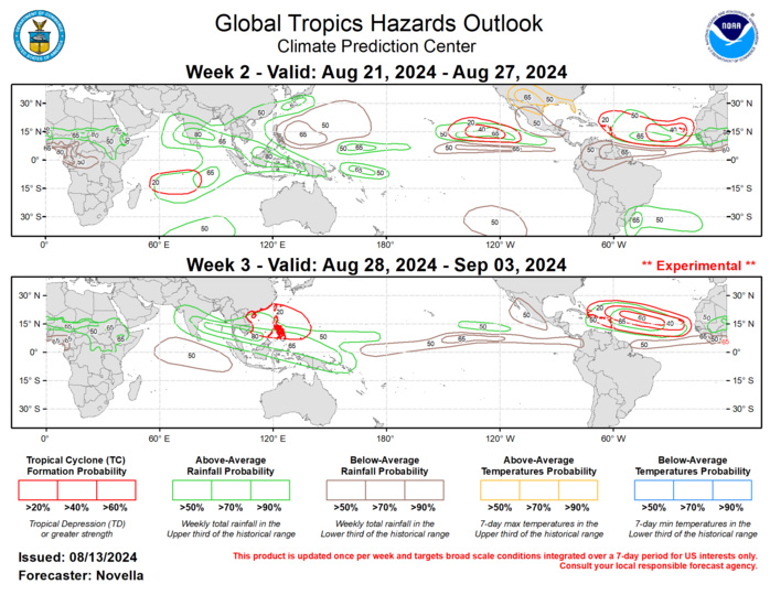
Forecasts for enhanced and suppressed precipitation for weeks 2 and 3 are based on historical composites of Indian Ocean and Maritime Continent MJO events, anticipated TC tracks, and a skill weighted consensus of the CFS, GEFS, ECMWF, and ECCC model systems, with some consideration of ENSO cold phase composites. Increased chances for above-normal temperatures, along with possible excessive heat conditions are forecast for the south-central CONUS during week-2. For hazardous weather conditions in your area during the next two weeks, please refer to your local NWS office, the Medium Range Hazards Forecast from the Weather Prediction Center (WPC), and the CPC Week-2 Hazards Outlook. Forecasts issues over Africa are made in coordination with the Africa Desk at CPC.
