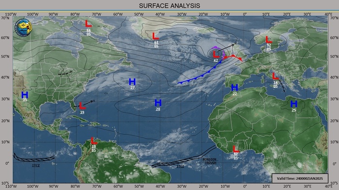
CLICK ON THE IMAGERIES BELOW TO GET THEM ENLARGED
2025 0124 00UTC +10 DAYS: : AREAS UNDER CLOSE WATCH FOR CYCLONIC DEVELOPMENT
SOUTHERN HEMISPHERE
1: MOZAMBIQUE CHANNEL
2: SOUTH INDIAN TO THE MASCARENE ISLANDS
3: NORTHWEST AUSTRALIA
4: GULF OF CARPENTARIA
5: CORAL SEA
SOUTHERN HEMISPHERE
1: MOZAMBIQUE CHANNEL
2: SOUTH INDIAN TO THE MASCARENE ISLANDS
3: NORTHWEST AUSTRALIA
4: GULF OF CARPENTARIA
5: CORAL SEA
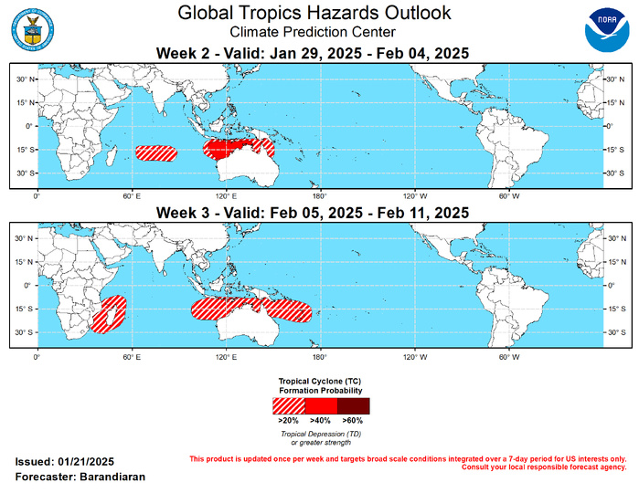
Last Updated - 01/21/25 3 WEEK TROPICAL CYCLONE FORMATION PROBABILITY

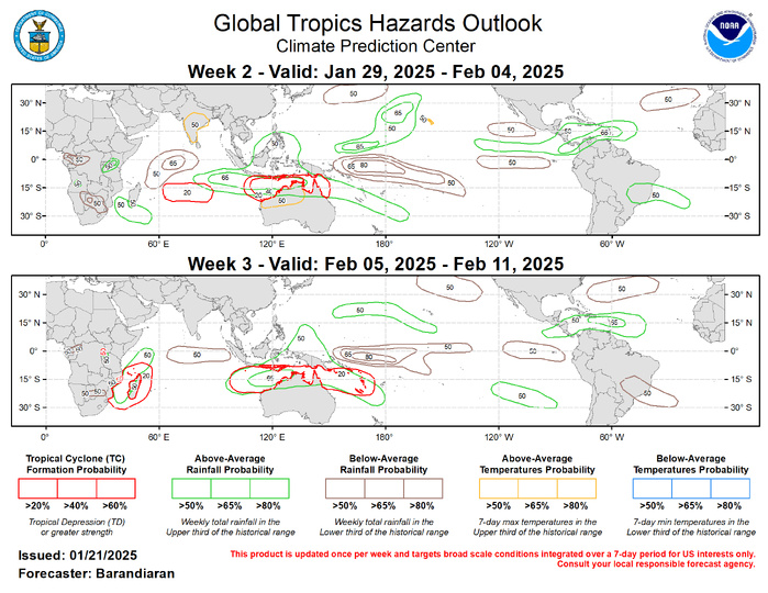
GTH Outlook Discussion Last Updated - 01/21/25 Valid - 01/29/25 - 02/11/25 After becoming incoherent during early January, RMM observations showed the MJO signal sharply regaining amplitude over the Western Hemisphere (phase 1) and then quickly propagating into the Indian Ocean. As the MJO moves from the Indian Ocean into the Maritime Continent, constructive interference with the emerging La Nina base state would tend to amplify the MJO. However, dynamical model RMM forecasts indicate a weakening of the MJO signal precisely when that interference should occur. The large-scale environment is expected to bring increased chances for tropical cyclone (TC) development in the Indian Ocean particularly near the northwest coast of Australia, while TC activity tends to be suppressed over the South Pacific. An eastward propagating Indian Ocean and Maritime Continent MJO historically favors a warm response over the central and eastern CONUS, which would be a welcome change to the frigid conditions currently being experienced over much of the Lower 48. One TC formed during the last week. On January 18 TC Sean formed northeast of Port Hedland on the northwest coast of Australia and intensified quickly, reaching Category 3-hurricane strength on the Saffir-Simpson scale. TC Sean has since weakened, and has generally moved Southwestward, following the western coast of Australia. In the coming days Sean is forecast to continue to weaken as it moves south, well away from the Australian coast. For the latest information on TC Sean please refer to the Joint Typhoon Warning Center (JTWC). With the MJO forecast to be in phases 4-5 (Maritime Continent) during the forecast period, the northern coast of Australia is favored to be the most active region for TC activity during weeks 2-3. During the week-2 period both the ECMWF and GEFS depict the highest probability of TC genesis northwest of Australia, warranting a moderate risk (40-60% probability) during week-2. As the MJO continues propagating eastward, enhanced probabilities of TC genesis spread eastward to the northeast coast of Australia by week-3, although only a slight risk (20-40% probability) is posted across the Australian coast. A slight risk of TC genesis is also posted for portions of the southern Indian Ocean throughout the forecast period, with the best chances of TC genesis shifting westward from the south-central Indian Ocean during week-2 to the Madagascar region during week-3.

The precipitation outlook for weeks 2 and 3 is based on potential TC activity, the anticipated state of ENSO and the MJO, and informed by GEFS, CFS, Canadian, and ECMWF ensemble mean solutions. During week-2 above-normal temperatures are indicated for the Hawaiian Islands, as well as much of southern India and portions of northwestern Australia. For hazardous weather conditions in your area during the coming two-week period, please refer to your local NWS office, the Medium Range Hazards Forecast produced by the Weather Prediction Center, and the CPC Week-2 Hazards Outlook. Forecasts made over Africa are made in coordination with the International Desk at CPC.


