CLICK ON THE IMAGERIES BELOW TO GET THEM ENLARGED
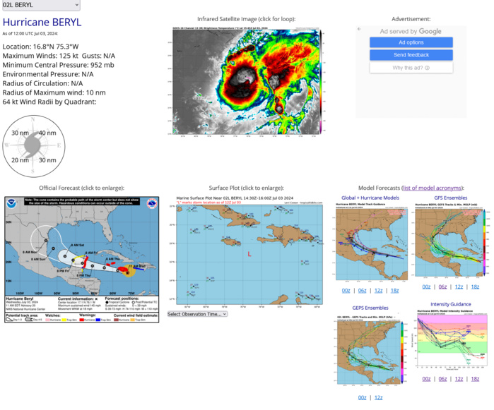
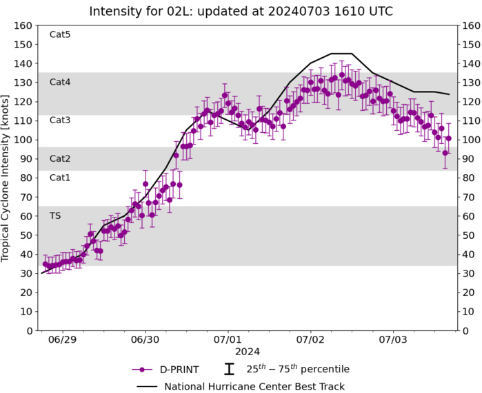
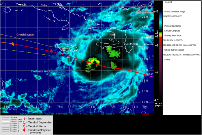
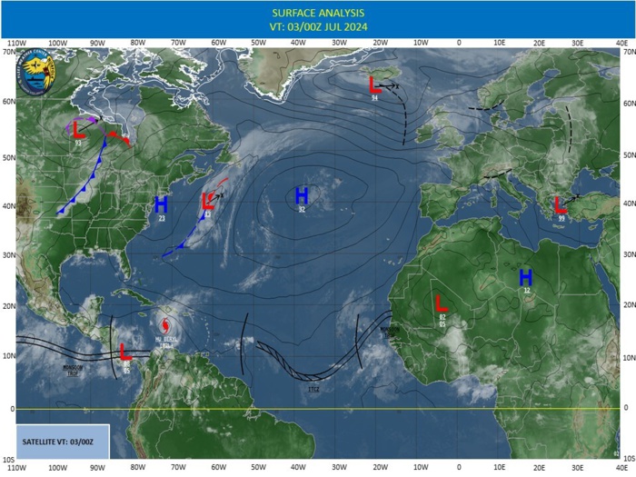
NORTH ATLANTIC OCEAN: HU 02L(BERYL). ESTIMATED LOCATION AND INTENSITY AT 03/12UTC. INTENSITY IS 125 KNOTS/CAT 4 US: -20 KNOTS OVER 24H
0224070106 115N 590W 105
0224070112 120N 605W 115
0224070118 128N 623W 130
0224070200 134N 640W 140
0224070206 142N 659W 145
0224070212 150N 679W 145
0224070218 156N 699W 135
0224070300 161N 718W 130
0224070306 163N 735W 125
0224070312 168N 753W 125
0224070112 120N 605W 115
0224070118 128N 623W 130
0224070200 134N 640W 140
0224070206 142N 659W 145
0224070212 150N 679W 145
0224070218 156N 699W 135
0224070300 161N 718W 130
0224070306 163N 735W 125
0224070312 168N 753W 125
ESTIMATED INTENSITY IS 125 KNOTS/CAT 4 US AT 03/15UTC. PEAK INTENSITY WAS 145 KNOTS/CAT 5 US
CLICK ON THE IMAGERY BELOW TO GET IT ANIMATED AND ENLARGED
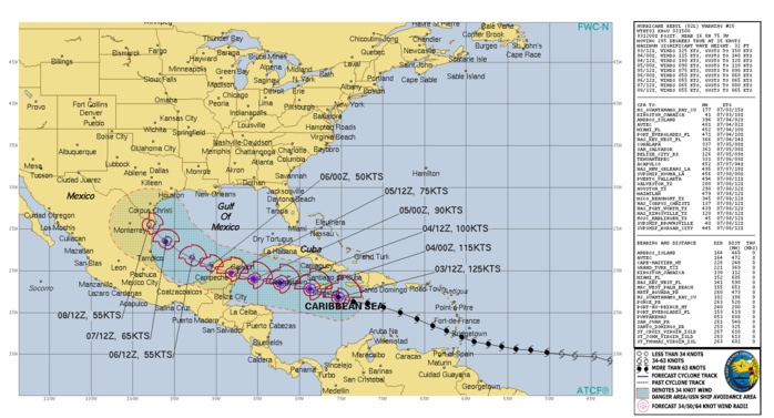
TC Warning Graphic: WARNING 20 ISSUED AT 03/15UTC+ NHC DISCUSSION
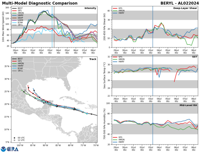
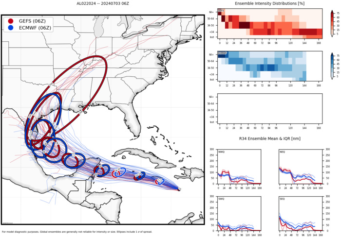
Model Diagnostic Plot
Ensemble Track Ellipses
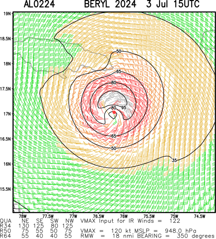
Multiplatform Satellite Surface Wind Analysis (Experimenta
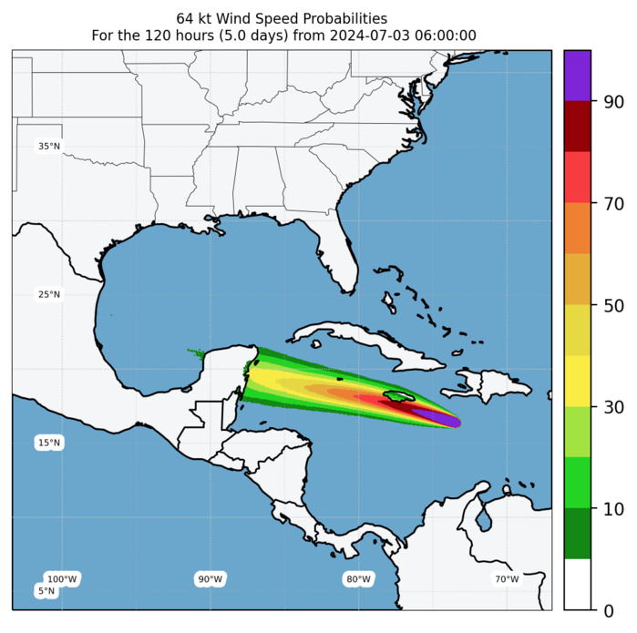
Experimental 64-kt Wind Speed Probabilities
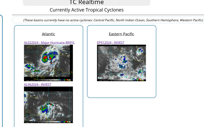
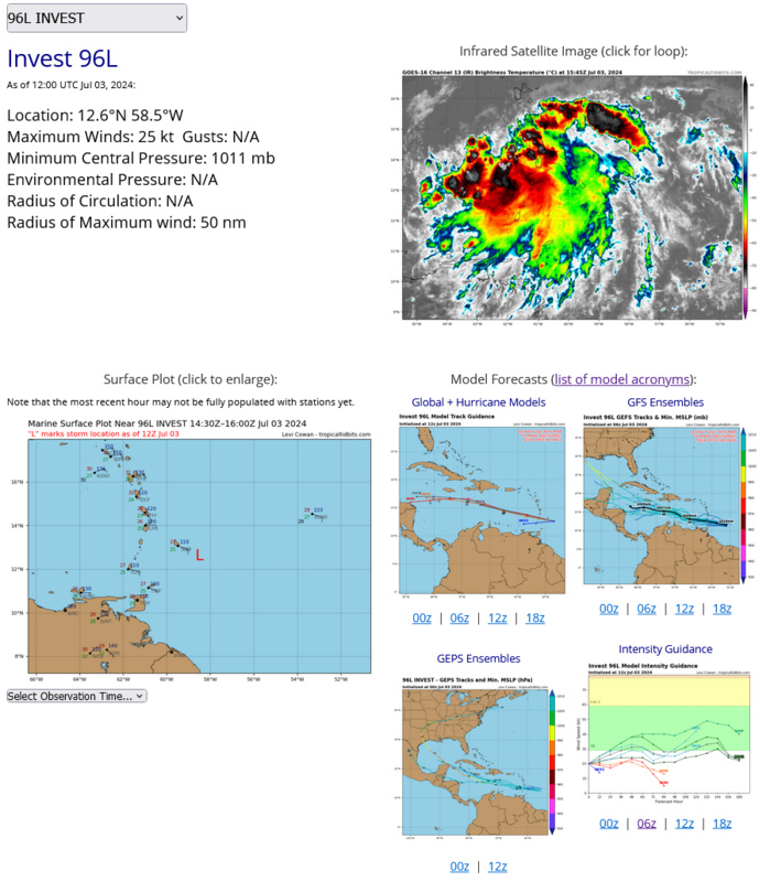
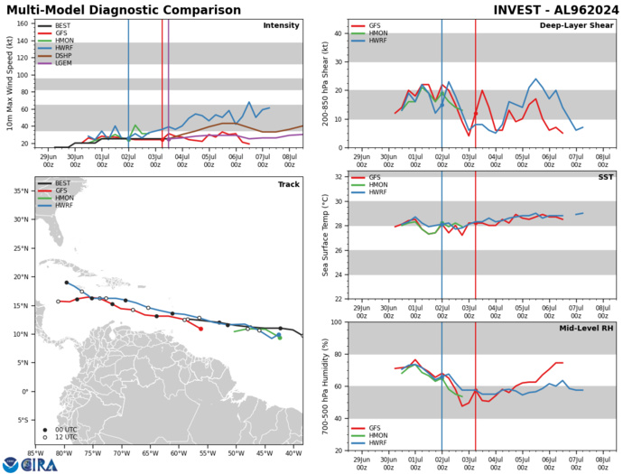
NORTH ATLANTIC OCEAN: INVEST 96L. ESTIMATED LOCATION AND INTENSITY AT 03/12UTC. INTENSITY IS 25 KNOTS
Model Diagnostic Plot
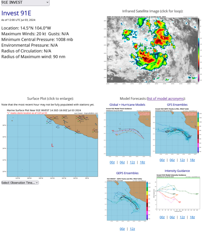
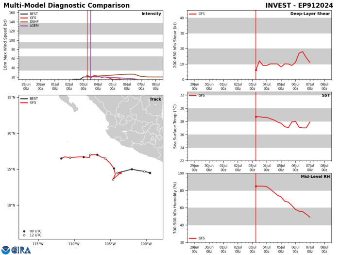
EASTERN NORTH PACIFIC: INVEST 91E. ESTIMATED LOCATION AND INTENSITY AT 03?12UTC. INTENSITY IS 20 KNOTS
Model Diagnostic Plot
Last Updated - 07/02/24 3 WEEK TROPICAL CYCLONE FORMATION PROBABILITY
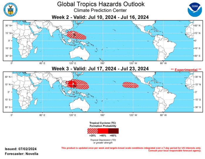
GTH Outlook Discussion Last Updated - 07/02/24 Valid - 07/10/24 - 07/23/24 Based on RMM observations, the Madden-Julian Oscillation (MJO) has remained incoherent for most of June, but has shown some signs of renewed activity over the Indian Ocean during the past week, which is also supported in the upper-level velocity potential and lower level wind anomaly fields. Following potential interference with equatorial Rossby wave activity leading to a brief westward retreat of the MJO signal in RMM space during week-1, dynamical models generally favor a resumption of an eastward propagating MJO signal over the Maritime Continent, however these forecasts maintain both a slow phase speed and notably low amplitude during the next couple of weeks. The latest upper-level velocity potential anomaly forecasts from the GEFS and ECMWF are also reflective of a slow phase speed, but point to a more organized MJO than the RMM forecasts based on a continued wave-1 pattern and an increase MJO based signals indicated in the objective wave-number frequency filtering as it crosses the Maritime Continent. Analysis of the predicted wind and OLR spatial fields suggests that this strength discrepancy in the MJO forecast tools may be attributed to anomalies that are of opposite sign on both sides of the equator, which could be offsetting any coherent intraseasonal activity in the RMM zonal averaging with the MJO expressing itself more over one hemisphere. As a result, the outlook relies more on velocity potential forecast guidance later in July, where constructive interference between the MJO and a low frequency footprint of enhanced divergence aloft established over the Maritime Continent is expected to provide a large-scale environment favorable for tropical cyclogenesis in the western Pacific. Conversely, decreased chances for Tropical Cyclone (TC) development are anticipated over the eastern Pacific and Atlantic towards the middle of July following a pair of TCs that formed during the past week in the Atlantic basin. In the Bay of Campeche, TC Chris formed on 7/1 and briefly peaked at Tropical Storm intensity before tracking over eastern Mexico and dissipating later in the day. Chris brought locally heavy rainfall, periods of high winds and flooding to parts of eastern Mexico within the last day. However, the big headliner is TC Beryl, which developed in the Main Development Region (MDR) on 6/29. This system underwent rapid intensification and became the first Major Hurricane of the Atlantic season, and has already brought heavy rainfall, strong winds, flooding and damages to infrastructure for many parts of the Lesser Antilles. Since yesterday, Beryl has intensified to a powerful, category 5 Hurricane strength this morning (becoming the earliest category 5 Hurricane on record in the Atlantic) and is currently located near 15N/67W to the south of Puerto Rico. Forecasts from the National Hurricane Center (NHC) have been consistent during the past few days, and favor a slight weakening of Beryl due to increased shearing as it tracks west-northwestward across the Caribbean under a steering subtropical ridge. Despite this weakening, Beryl looks to adversely impact Jamaica and the Cayman Islands in the coming days where Hurricane Warnings are in effect as of 11am AST. Later this week, there is increased uncertainty with the exact location and strength of Beryl, but the latest official track from the NHC shows Beryl crossing the Yucatan and entering the Gulf of Mexico at Tropical Storm strength by this weekend. Regardless of whether Beryl becomes post-tropical or maintains its structure at this lead, there has been good continuity in several of the GEFS and ECMWF ensemble members curving the disturbance northwestward in the Gulf of Mexico late in week-1, and possibly bring heavy precipitation and high winds for parts of the western Gulf Coast states early in week-2. Please refer to CPCs Week-2 U.S. Hazards Outlook (https://www.cpc.ncep.noaa.gov/products/predictions/threats/threats.php) for more information on potential regional impacts. Behind Hurricane Beryl, the NHC continues to monitor another tropical disturbance (96L) in the MDR. Over the past few days, the NHC has backed off on its odds of formation (dropping from 70% to 30% chances for development in the next 7 days) consistent with the trends in the probabilistic TC tools. The last several runs of the GEFS has become more aggressive with redeepening the low as it approaches the Gulf of Honduras late in week-1, however the ECMWF is less onboard with this realization. Given this disagreement in the models, no corresponding TC area is issued, though precipitation could be enhanced over parts of the Caribbean and Gulf of Mexico during week-2. In the eastern Pacific, the NHC is also eyeing a broad area of low pressure to the south of Mexico with 50% chances for genesis during the next week. Deterministic solutions from GFS and ECMWF have become better aligned with this potential, though any TC that forms is likely to be short-lived given an increase in shearing conditions favored in the basin, likely tied to the suppressed phase of the MJO moving in later this week. For week-2, 20% chances for TC formation are posted across the South China and the Philippine Seas based on increasingly favorable circulation conditions, and some support in the probabilistic TC genesis tools. Towards the end of week-2, an equatorial Rossby wave is predicted to traverse the basin, and the GEFS features the development of a broadly cyclonic wind pattern consistent with a possible gyre event in the basin. In light of this, as well as increased support from the extended range ECMWF probabilistic tool indicating higher than normal chances above climatology, 40% chances are issued for week-3 centered over the South China Sea, with a broad 20% area extending eastward into the Philippine Sea. In the western Hemisphere, no TC formation areas are issued over eastern Pacific and the MDR for week-2 based on increased shearing conditions favored in the ensembles, little to no support in the probabilistic tools, and the suppressed phase of the MJO overspreading the tropical Americas. By week-3 though, the environment could become conducive for TC development over parts of the central and eastern Pacific, and 20% chances are posted from approximately 140W to 100W.
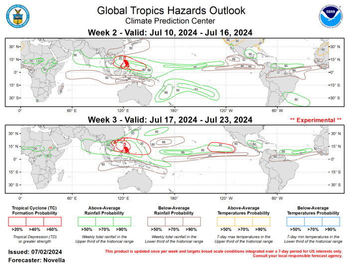
The precipitation outlook for weeks 2 and 3 is based on a historical skill weighted blend of GEFS, ECMWF, CFS, and ECCC model guidance, MJO composites, and anticipated TC tracks. For temperatures, the continuation of potent mid-level ridging favored over western North America supports elevated chances for above-normal temperatures and an increased risk of excessive heat conditions for many parts of California, the Pacific Northwest, Interior West and portions of the High Plains during week-2. Based on bias-corrected and calibrated temperature guidance, excessive heat conditions are also possible across parts of northwestern Africa with daytime maximums possibly exceeding 115 deg F in some areas. For hazardous weather conditions in your area during the next two weeks, please refer to your local NWS office, the Medium Range Hazards Forecast from the Weather Prediction Center, and the CPC Week-2 Hazards Outlook. Forecasts issued over Africa are made in coordination with the International Desk at CPC.
