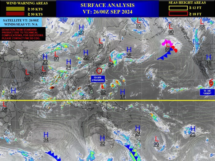
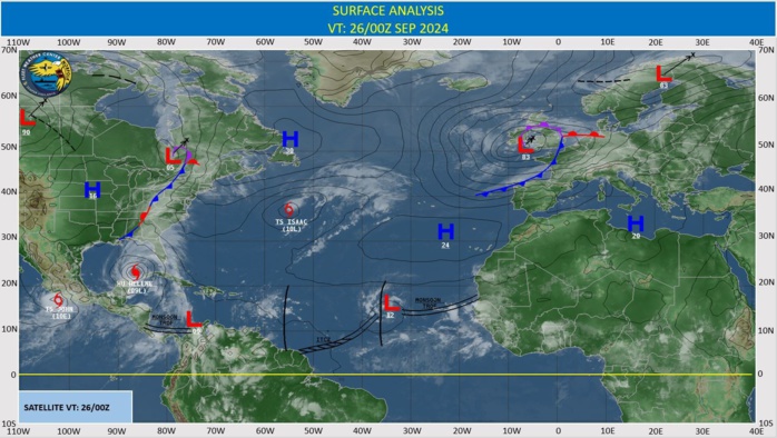
CLICK ON THE IMAGERIES BELOW TO GET THEM ENLARGED
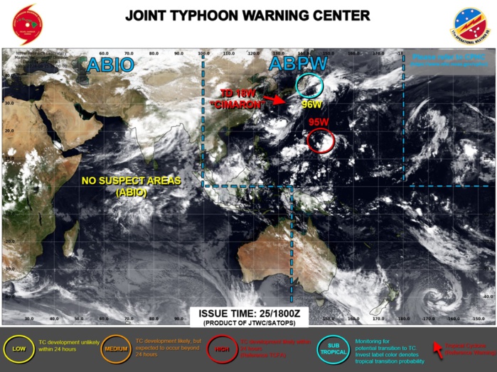
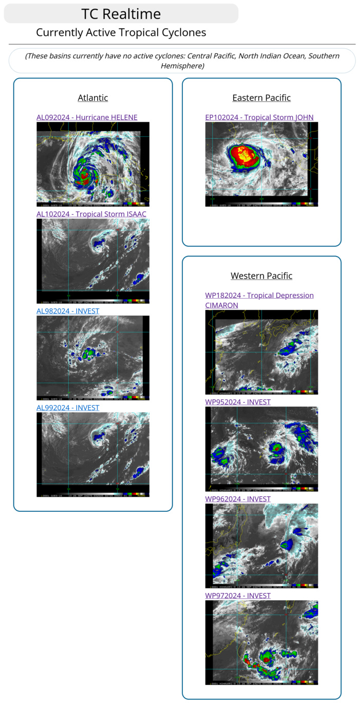
WESTERN NORTH PACIFIC AREA (180 TO MALAY PENINSULA): A. TROPICAL CYCLONE SUMMARY: (1) AT 25SEP24 1200Z, TROPICAL DEPRESSION 18W (CIMARON) WAS LOCATED NEAR 27.8N 133.3E, APPROXIMATELY 556 NM SOUTHWEST OF YOKOSUKA, JAPAN, AND HAD TRACKED SOUTHWESTWARD AT 07 KNOTS OVER THE PAST SIX HOURS. MAXIMUM SUSTAINED SURFACE WINDS WERE ESTIMATED AT 30 KNOTS GUSTING TO 40 KNOTS. SEE REF A (WTPN31 PGTW 251500) FOR FURTHER DETAILS. (2) NO OTHER TROPICAL CYCLONES. B. TROPICAL DISTURBANCE SUMMARY: (1) THE AREA OF CONVECTION (INVEST 95W) PREVIOUSLY LOCATED NEAR 15.5N 149.3E IS NOW LOCATED NEAR 16.1N 148.3E, APPROXIMATELY 157 NM EAST-NORTHEAST OF SAIPAN. ANIMATED ENHANCED INFRARED SATELLITE IMAGERY DEPICTS A PARTIALLY-EXPOSED LOW-LEVEL CIRCULATION CENTER, WITH FLARING DEEP CONVECTION ALONG THE EASTERN AND SOUTHERN PERIPHERIES. A 251044Z MHS 89GHZ MICROWAVE IMAGE SHOWS BROAD CONVECTIVE BANDING, WITH WEAK LOW-LEVEL STRUCTURE. RECENT SCATTEROMETRY DATA INDICATES A SWATH OF 20 TO 25 KNOT CONVERGENT WINDS OVER THE EASTERN AND SOUTHERN SEMICIRCLES, WHICH IS FUELING THE AFOREMENTIONED EXTENSIVE DEEP CONVECTIVE BURSTS. ENVIRONMENTAL ANALYSIS INDICATES MARGINALLY FAVORABLE CONDITIONS, WITH WARM SEA SURFACE TEMPERATURES (29-30 C) AND GOOD EQUATORWARD OUTFLOW ALOFT, OFFSET BY MODERATE TO HIGH (20 TO 25 KNOTS) VERTICAL WIND SHEAR. GLOBAL MODELS ARE IN GOOD AGREEMENT THAT THE SYSTEM WILL CONTINUE TO TRACK NORTHWESTWARD WITH GRADUAL INTENSIFICATION OVER THE NEXT 12-36 HOURS. MAXIMUM SUSTAINED SURFACE WINDS ARE ESTIMATED AT 20 TO 25 KNOTS. MINIMUM SEA LEVEL PRESSURE IS ESTIMATED TO BE NEAR 1004 MB. THE POTENTIAL FOR THE DEVELOPMENT OF A SIGNIFICANT TROPICAL CYCLONE WITHIN THE NEXT 24 HOURS IS UPGRADED TO HIGH. SEE REF B (WTPN21 PGTW 251500) FOR FURTHER DETAILS. (2) NO OTHER SUSPECT AREAS. C. SUBTROPICAL SYSTEM SUMMARY: (1) AN AREA OF CONVECTION (INVEST 96W) HAS PERSISTED NEAR 33.7N 142.9E, APPROXIMATELY 186 NM EAST-SOUTHEAST OF YOKOSUKA, JAPAN. THE SYSTEM IS CURRENTLY CLASSIFIED AS A SUBTROPICAL STORM, GENERALLY CHARACTERIZED AS HAVING BOTH TROPICAL AND MIDLATITUDE CYCLONE FEATURES. ANIMATED ENHANCED INFRARED SATELLITE IMAGERY DEPICTS A BROAD, RAGGED LOW-LEVEL CIRCULATION CENTER, WITH POORLY-ORGANIZED DEEP CONVECTION DISPLACED TO THE EAST. A 251050Z ASCAT-C PARTIAL IMAGE REVEALS A PATCH OF 30-35 KNOT WINDS OVER THE NORTHEASTERN QUADRANT. UPPER-LEVEL ANALYSIS INDICATES UNFAVORABLE CONDITIONS CHARACTERIZED BY HIGH (40-50 KNOTS) VERTICAL WIND SHEAR AND BROAD DIVERGENCE NOT CONDUCIVE FOR TROPICAL CYCLONE DEVELOPMENT. GLOBAL MODELS INDICATE A NORTHEASTWARD TRACK AWAY FROM HONSHU, WITH EXTRA-TROPICAL TRANSITION AS THE SYSTEM TRACKS INTO A STRONG BAROCLINIC ZONE SITUATED OVER THE NORTHERN PACIFIC OCEAN. FOR HAZARDS AND WARNINGS, REFERENCE THE FLEET WEATHER CENTER SAN DIEGO HIGH WINDS AND SEAS PRODUCT OR REFER TO LOCAL WMO DESIGNATED FORECAST AUTHORITY. MAXIMUM SUSTAINED SURFACE WINDS ARE ESTIMATED AT 30 TO 35 KNOTS. MINIMUM SEA LEVEL PRESSURE IS ESTIMATED TO BE NEAR 1006 MB. THE POTENTIAL FOR THE DEVELOPMENT OF A SIGNIFICANT TROPICAL CYCLONE WITHIN THE NEXT 24 HOURS IS LOW.
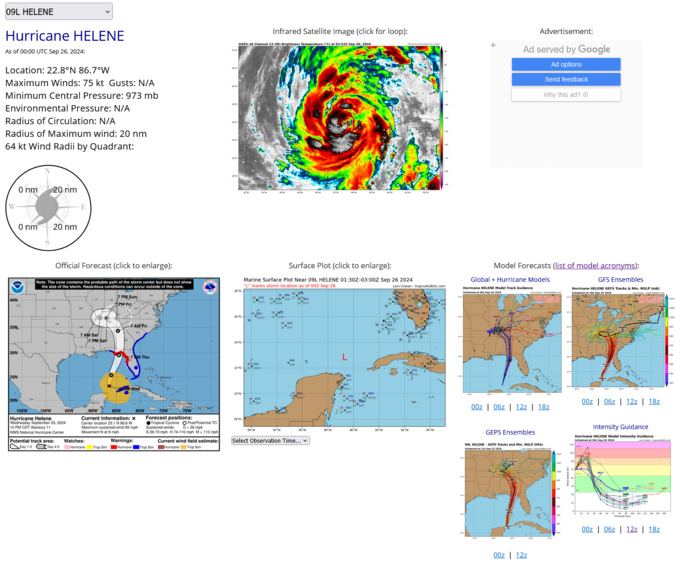
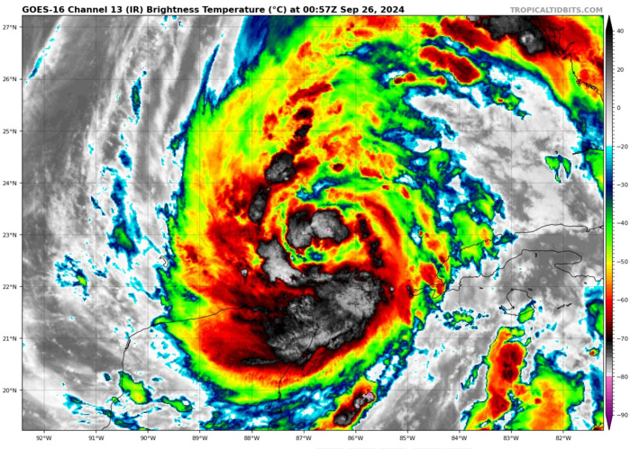
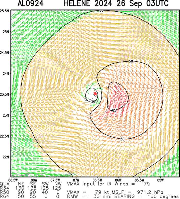
FOCUS OF THE DAY: NORTH ALTANTIC/GULF OF MEXICO: HURRICANE 09L(HELENE). 26/00UTC ESTIMATED LOCATION AND INTENSITY.
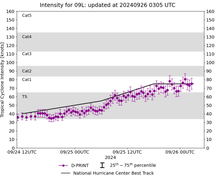
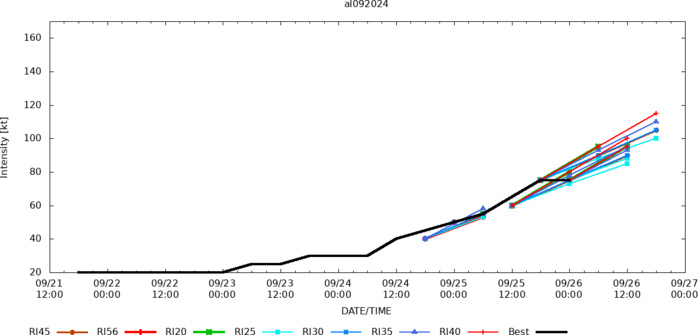
CURRENT INTENSITY IS 75 KNOTS CAT 1 US: +25 KNOTS OVER 24 HOURS.
0924092118 136N 827W 20
0924092200 140N 826W 20
0924092206 144N 826W 20
0924092212 148N 826W 20
0924092218 152N 826W 20
0924092300 156N 825W 20
0924092306 160N 820W 25
0924092312 172N 818W 25
0924092318 179N 819W 30
0924092400 182N 821W 30
0924092406 186N 827W 30
0924092412 192N 836W 40
0924092418 194N 846W 45
0924092500 197N 852W 50
0924092506 203N 859W 55
0924092512 211N 862W 65
0924092518 220N 864W 75
0924092600 228N 867W 75
26/00UTC SATELLITE ANALYSIS
TXNT29 KNES 260030
TCSNTL
A. 09L (HELENE)
B. 26/0001Z
C. 22.8N
D. 86.7W
E. THREE/GOES-E
F. T5.0/5.0
G. IR/EIR/SWIR
H. REMARKS...LLCC EMBEDDED IN DG YIELDS A DT OF 4.0. THE MET IS 5.0
BASED ON A 24HR RAPID DEVELOPING TREND. THE PT IS ALSO 5.0. THE FT IS
BASED ON THE MET DUE TO UNCERTAINTY IN EXACT CENTER LOCATION.
I. ADDL POSITIONS
NIL
...GATLING
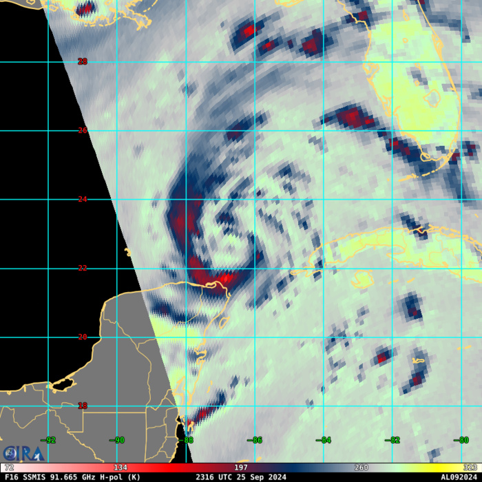
85 – 92 GHz Brightness Temperature
TC Warning Graphic NHC DISCUSSION
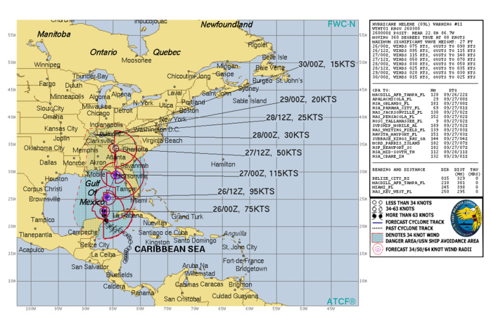
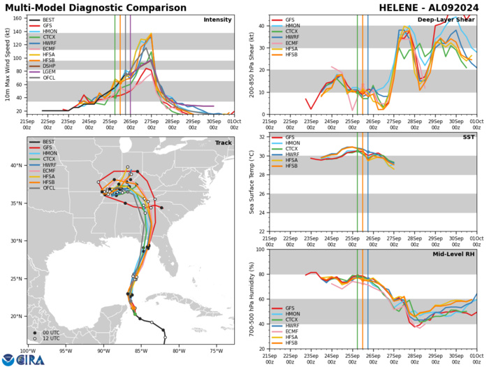
Satellite images show that Helene has a well-organized appearance, with numerous convective banding features. A ragged-looking eye feature is also apparent. However, reports from both Air Force and a NOAA Hurricane Hunter aircraft investigating the system suggest that the it lacks a well-defined inner core with a somewhat broad maximum wind field for now. The central pressure has dropped a little to around 972 mb. Given the slowly falling central pressure, the intensity is maintained at 75 kt for this advisory. Helene's structure and intensity will continue to be closely monitored by Hurricane Hunter aircraft tonight and Thursday. The hurricane continues moving northward with an estimated initial motion of 360/08 kt. For the next couple of days, the steering scenario for this system remains basically unchanged from the earlier advisory. The flow between a mid-tropospheric trough over the east-central United States and a ridge over the western Atlantic should result in Helene accelerating northward to north-northeastward during the next 24 to 36 hours. This motion will bring the center of Helene to the northeastern Gulf of Mexico coast in about 24 hours. The official track forecast through landfall is very similar to the previous NHC prediction and remains close to the corrected consensus guidance. After landfall, the trough to the northwest of the tropical cyclone becomes a cutoff low, and Helene should turn leftward as it rotates around the low. In 3-4 days, the system should become a shallow extratropical cyclone within weaker steering currents. Helene should be in an atmospheric and oceanic environment over the eastern Gulf of Mexico that will be very conducive for strengthening. The system is expected to traverse the Loop Current, which has especially high oceanic heat content. This, along with fairly low vertical wind shear and a moist mid- to lower- tropospheric air mass, should likely result in rapid intensification before landfall. The official forecast continues to call for the hurricane to reach category 4 status tomorrow. It should be noted that the HAFS-A and HAFS-B regional hurricane models show even more intensification than indicated here. Helene is forecast to be a large major hurricane when it reaches the Big Bend coast of Florida. As a result, storm surge, wind, and rainfall impacts will extend well away from the center and outside the forecast cone, particularly on the east side. In addition, the fast forward speed when Helene moves inland will result in a far inland penetration of strong winds over parts of the southeastern United States, including strong gusts over higher terrain of the southern Appalachians. A higher-than-normal gust factor is indicated in the official forecast while Helene is inland.
Model Diagnostic Plot
Rapid Intensification Guidance
Multiplatform Satellite Surface Wind Analysis (Experimental)
Last Updated - 0924/24 3 WEEK TROPICAL CYCLONE FORMATION PROBABILITY
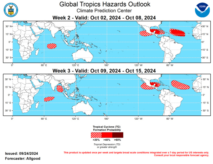
GTH Outlook Discussion Last Updated - 09/24/24 Valid - 10/02/24 - 10/15/24 Following a period of increased incoherence over the Maritime Continent, the RMM-based MJO index showed propagation over the Pacific during the past week, consistent with forecast guidance considered in the previous release of the Global Tropical Hazards Outlook. The inability for the signal to cross the Maritime Continent through much of early to mid September was due in part to the base state that continues to transition towards La Niña conditions, as well as alternatingly destructive and constructive interference with strong equatorial Rossby wave (ERW) activity over the far West Pacific and Maritime Continent. While east-central Pacific SSTs and upper-oceanic heat content continue to decline, the atmospheric response has been somewhat out of phase with a typical La Niña event, with increased suppression displaced to the east, over portions of the Western Hemisphere. This displaced response, coupled with enhanced West Pacific convection, helped to diminish tropical cyclone activity across the Atlantic basin during the climatological peak of hurricane season. During the next few weeks, dynamical model forecasts of the RMM index are in good agreement supporting continued eastward propagation of the MJO across the Western Hemisphere and Indian Ocean, followed by weakening and a potential quick return to the Maritime Continent. MJO events crossing the Indian Ocean typically result in reduced shear and low-level westerly winds across the Atlantic basin, which are favorable for tropical cyclone development. Additionally, the intraseasonal signal may help enhance the Central American Gyre (CAG) during much of the outlook period, which would promote increased convection and broad areas of low pressure across the far eastern Pacific, central America, and the western Caribbean. Therefore, the MJO is favored to play a substantial role in the overall evolution of the tropical convective pattern, primarily by reversing the previously persistent pattern of subsidence over the Western Hemisphere, yielding a window of favorability for late-season tropical cyclone development. Since September 18, three tropical cyclones developed globally. On September 22, Tropical Storm 17 formed over the Taiwan Strait immediately before moving ashore over mainland China. On September 23, Hurricane John formed over the East Pacific just south of Mexico, undergoing a remarkably rapid intensification to Category-3 intensity on the Saffir-Simpson scale just before landfall near Punta Maldonado. On September 24, Tropical Storm Helene formed over the far western Caribbean. Forecasts from the National Hurricane Center (NHC) bring Helene northward over the next several days, with a potential landfall over Florida’s Panhandle of Big Bend regions. Tropical Storm Helene also has the potential for rapid intensification, and current forecasts show the system at major hurricane intensity (Category-3 on the Saffir-Simpson scale) just prior to landfall. Please refer to the NHC for further updates on this system. During Week-2, low-level zonal westerlies are favored to develop across the far eastern Pacific and western Caribbean due to MJO activity, along with an enhanced CAG, support a continued active pattern, with additional tropical cyclone development possible over the East Pacific, southern Gulf of Mexico, and the western Caribbean. The highest probabilities for development extend from the Bay of Campeche eastward to the western Caribbean. Additionally, the Main Development Region (MDR) of the Atlantic is also favored to remain active, with tropical cyclogenesis favored in the region between the Lesser Antilles and the Cape Verde Islands. This enhanced activity may continue into Week-3, though dynamical model guidance becomes more diffuse. Additional development is possible over the far eastern Pacific, though the potential will decrease later into Week-3. A greater than 40-percent chance of formation is maintained across the Bay of Campeche and far western Caribbean during Week-3. Over the MDR, additional tropical cyclone development is possible, though tropical waves emerging during mid-October tend to take longer to develop. Elsewhere, a quieter pattern is favored for the West Pacific as the suppressed phase of the MJO overspreads the basin, though there is a slight chance for formations in the vicinity of Taiwan or north of the Philippines. Dynamical models indicate a potential for early season development across the south-central Indian Ocean, possibly in association with westerly wind bursts generated by MJO activity. During Week-3, dynamical models show a potential for development increasing over the Bay of Bengal as well.
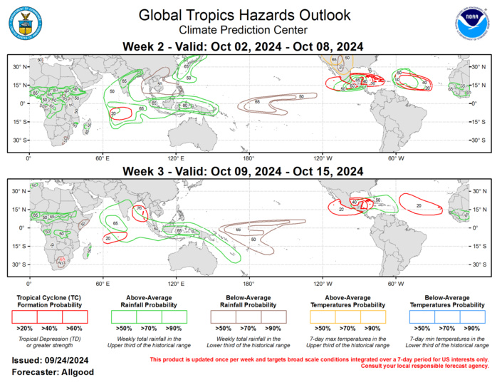
Forecasts for above- and below-normal precipitation are based on composites of MJO activity when the signal crosses the Indian Ocean, along with an anticipated continuation of enhanced convection over the Maritime Continent due to the low frequency base state. A reversal of suppressed conditions is favored for portions of the Western Hemisphere, while trade winds are favored to re-strengthen over the central Pacific after a period of disruption caused by MJO activity. For hazardous weather concerns in your area during the next two weeks, please refer to your local NWS office, the Medium Range Hazards Forecast from the Weather Prediction Center (WPC), and the CPC Week-2 Hazards Outlook. Forecasts issued over Africa are made in coordination with the International Desk at CPC.
