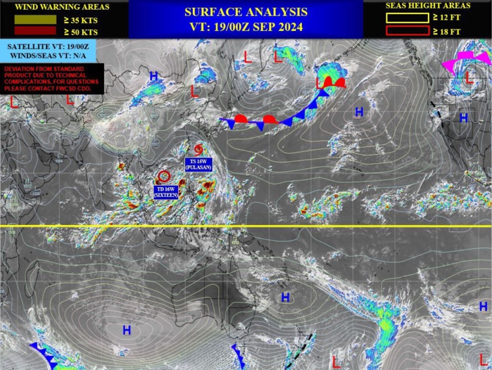
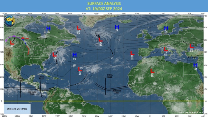
CLICK ON THE IMAGERIES BELOW TO GET THEM ENLARGED
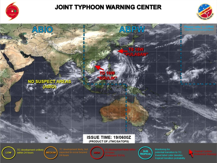
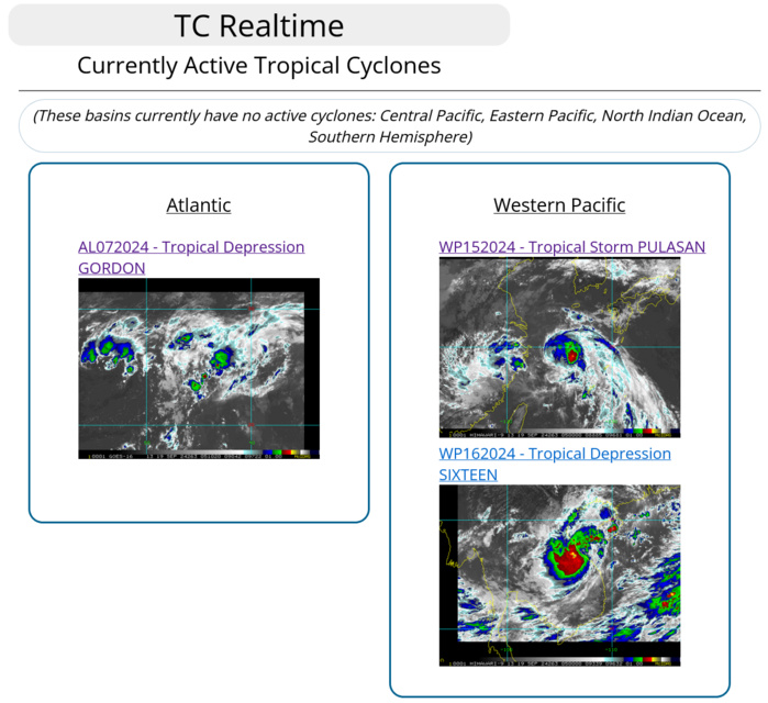
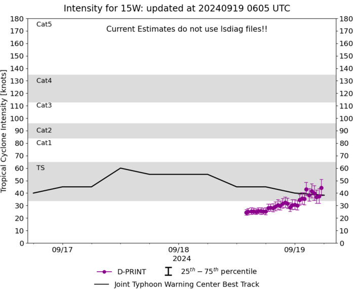
WESTERN NORTH PACIFIC: TS 15W(PULASAN). 19/00UTC ESTIMATED LOCATION AND INTENSITY. INTENSITY IS 40 KNOTS: - 15 KNOTS OVER 24 HOURS
1524091418 122N1446E 15
1524091500 125N1443E 15
1524091506 129N1441E 20
1524091512 134N1437E 20
1524091518 140N1432E 30
1524091600 146N1427E 35
1524091606 162N1420E 35
1524091612 167N1409E 35
1524091618 176N1405E 40
1524091700 185N1387E 45
1524091706 201N1364E 45
1524091712 213N1345E 60
1524091718 223N1334E 55
1524091800 231N1317E 55
1524091806 243N1300E 55
1524091806 243N1300E 55
1524091812 260N1287E 45
1524091818 270N1278E 45
1524091900 287N1261E 40
WARNING 10 ISSUED AT 19/03UTC
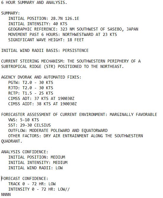
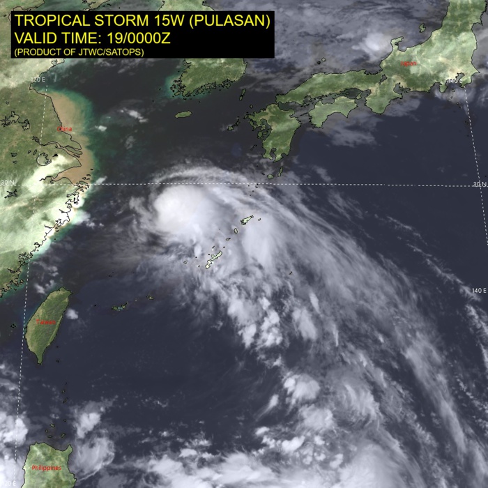
SATELLITE ANALYSIS, INITIAL POSITION AND INTENSITY DISCUSSION: ANIMATED MULTISPECTRAL SATELLITE IMAGERY (MSI) DEPICTS 15W (PULASAN) WITH A FEATURES MORE CONSISTENT WITH A TROPICAL CYCLONE VICE A MONSOON DEPRESSION. THE LOW-LEVEL CIRCULATION CENTER (LLCC) HAS CONTINUED TO CONSOLIDATE WITH PERSISTENT CONVECTION OVER THE CENTER. ENVIRONMENTAL ANALYSIS INDICATES THAT 15W IS CURRENTLY IN A MARGINALLY FAVORABLE ENVIRONMENT CHARACTERIZED BY MODERATE OUTFLOW ALOFT, LOW (5-10 KTS) VERTICAL WIND SHEAR, AND WARM (29-30 C) SEA SURFACE TEMPERATURES OFFSET BY DRY AIR ENTRAINMENT. THE INITIAL POSITION IS PLACED WITH MEDIUM CONFIDENCE BASED ON THE ANIMATED MSI SHOWING THE CONSOLIDATING LLCC. THE INITIAL INTENSITY OF 40 KTS IS ASSESSED WITH MEDIUM CONFIDENCE BASED ON THE HIGH END OF INTENSITY ESTIMATES LISTED.
TC Warning Graphic
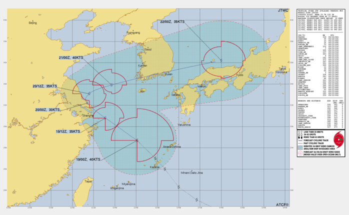
FORECAST REASONING. SIGNIFICANT FORECAST CHANGES: THERE ARE NO SIGNIFICANT CHANGES TO THE FORECAST FROM THE PREVIOUS WARNING. FORECAST DISCUSSION: 15W IS FORECAST TO CONTINUE TRACKING NORTHWESTWARD ALONG THE PERIPHERY OF THE STR TO THE NORTHEAST THROUGH TAU 24. NEAR TAU 24, 15W IS ANTICIPATED TO MAKE LANDFALL NEAR SHANGHAI AND A TROUGH THAT BEGINS TO BREAK DOWN AN EXTENSION OF THE RIDGE CREATES A WEAK STEERING ENVIRONMENT CAUSING VERY SLOW TRACK SPEEDS AROUND THAT TIME. AT TAU 36, 15W IS FORECAST TO THEN START AN EAST-NORTHEASTWARD TRACK AS THE RIDGE TAKES OVER AS THE PRIMARY STEERING INFLUENCE ONCE AGAIN. AROUND TAU 48, TRACK SPEEDS ARE EXPECTED TO GREATLY INCREASE DUE TO INTERACTION WITH THE JET MARKING THE BEGINNING OF EXTRATROPICAL TRANSITION. THE SYSTEM WILL THEN TRACK BRISKLY ALONG THE SOUTHERN COAST OF SOUTH KOREA IN THE KOREA STRAIT AND INTO THE SEA OF JAPAN. AS A RESULT OF THE BAROCLINIC ZONE BEING PUSHED SOUTH BY THE TROUGH, 15W IS FORECAST TO QUICKLY COMPLETE EXTRATROPICAL TRANSITION NEAR TAU 72. REGARDING INTENSITY, 15W IS EXPECTED TO GRADUALLY WEAKEN AS IT HEADS TOWARD SHANGHAI WHERE IT MAKES LANDFALL AS A BORDERLINE TROPICAL STORM. ONCE THE SYSTEM MAKES IT BACK OUT OVER WATER, A STEADY INTENSIFICATION TREND WILL ENSUE, HOWEVER STRONG VERTICAL WIND SHEAR WILL CAP THE INTENSITY TO A PEAK OF 40 KTS.
Model Diagnostic Plot
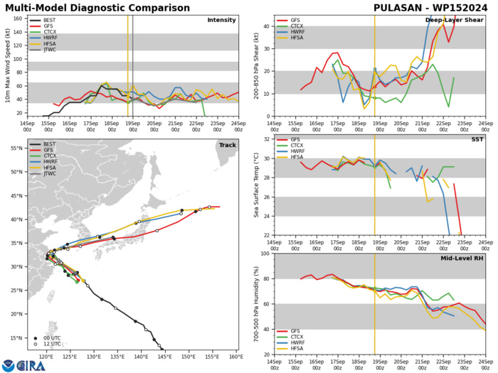
MODEL DISCUSSION: NUMERICAL MODEL GUIDANCE IS IN BETTER AGREEMENT WITH A LARGER BULK OF GUIDANCE SHOWING THE SHARP TURN BACK OVER WATER RATHER THAN DISSIPATION OVER EASTERN CHINA. AFTER TAU 36, MODELS VARY IN THE SHARPNESS OF THE TURN WITH HWRF AND HAFS-A BOTH TRACKING THE VORTEX THROUGH SOUTHERN SOUTH KOREA WHILE GFS AND ITS ENSEMBLE MEAN A BIT FURTHER SOUTH, OFF THE COAST OF SOUTH KOREA. THE JTWC TRACK FORECAST IS PLACED WITH OVERALL LOW CONFIDENCE DUE TO THE CONTINUED POSSIBILITY OF DISSIPATION IN EASTERN CHINA. INTENSITY GUIDANCE IS IN MODERATE AGREEMENT WITH SOME VARIANCE DUE TO TRACK DIFFERENCES AND TIME OVER LAND. THE JTWC INTENSITY FORECAST IS PLACED CLOSE TO CONSENSUS WITH LOW CONFIDENCE AS WELL FOR SIMILAR REASONS.
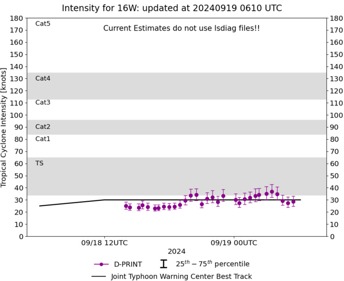
WESTERN NORTH PACIFIC: TD 16W(SOULIK). 19/00UTC ESTIMATED LOCATION AND INTENSITY. INTENSITY IS 30 KNOTS: + 10 KNOTS OVER 24 HOURS
1624091712 194N1169E 15
1624091718 189N1161E 15
1624091800 183N1151E 20
1624091806 176N1136E 25
1624091812 175N1113E 30
1624091818 174N1099E 30
1624091900 173N1081E 30
1624091718 189N1161E 15
1624091800 183N1151E 20
1624091806 176N1136E 25
1624091812 175N1113E 30
1624091818 174N1099E 30
1624091900 173N1081E 30
WARNING 4 ISSUED AT 19/03UTC
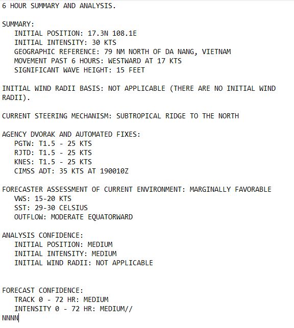
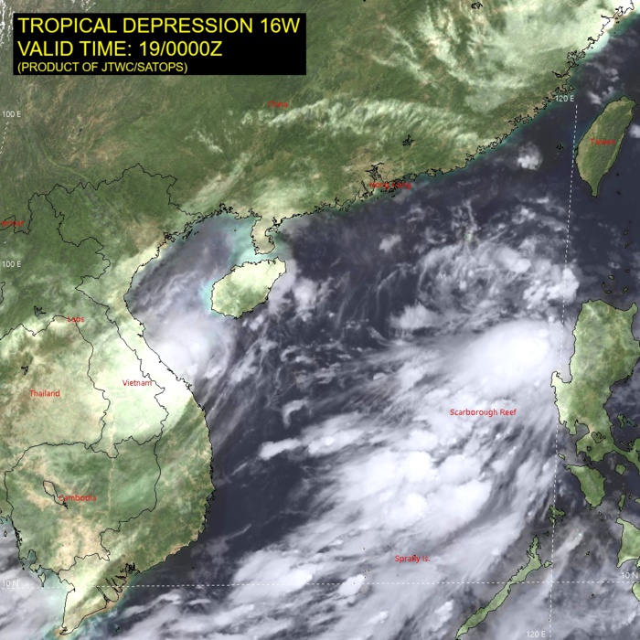
SATELLITE ANALYSIS, INITIAL POSITION AND INTENSITY DISCUSSION: ANIMATED MULTISPECTRAL SATELLITE IMAGERY (MSI) DEPICTS A BROAD AND DISORGANIZED LOW-LEVEL CIRCULATION OBSCURED BY FLARING CONVECTION. TD 16W IS MOVING TOWARDS THE NORTHERN COAST OF VIETNAM, ENCOUNTERING MARGINALLY FAVORABLE, YET STEADILY DEGRADING ENVIRONMENTAL CONDITIONS. AFTER A BRIEF PERIOD OF MINOR CONSOLIDATION, THE OUTFLOW IS GENERALLY RESTRICTED TOWARDS THE REGION SOUTH-WEST OF THE SYSTEM. THE INITIAL POSITION IS PLACED WITH MEDIUM CONFIDENCE BASED ON VISIBLE, ANIMATED EIR IMAGERY, AS WELL AS PGTW RADAR FIX. THE INITIAL INTENSITY OF 30 KTS IS ASSESSED WITH MEDIUM CONFIDENCE BASED ON THE AGENCY AND OBJECTIVE FIXES LISTED.
TC Warning Graphic
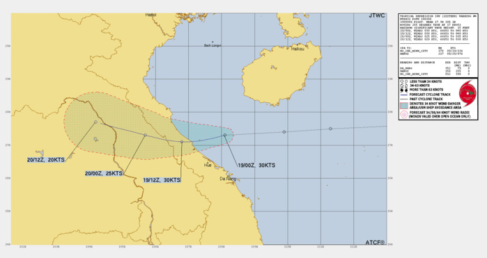
FORECAST REASONING. SIGNIFICANT FORECAST CHANGES: THERE ARE NO SIGNIFICANT CHANGES TO THE FORECAST FROM THE PREVIOUS WARNING. FORECAST DISCUSSION: TD 16W SPEED OVER WATER INCREASED TO 17 KTS SINCE THE LAST FORECAST AND THE SYSTEM IS HEADING TOWARDS NORTHERN VIETNAM AND IS EXPECTED TO MAKE LANDFALL APPROXIMATELY 90 NM NORTHWEST OF DA NANG, WHILE MAINTAINING ITS CURRENT INTENSITY OF 30 KTS. SINCE THEN, DUE TO TERRAIN INTERACTION, TD 16W IS FORECAST TO BEGIN STEADY WEAKENING DOWN TO 20 KTS INTENSITY BY TAU 36. WHILE THE SEA SURFACE TEMPERATURES ARE LOWERING, THE 29-30 DEGREES CELSIUS ARE STILL FAVORABLE. VERTICAL WIND SHEAR HOWEVER IS ON THE HIGHER END OF THE 15-20 KTS THRESHOLD, HINDERING ANY FURTHER DEVELOPMENT.
Model Diagnostic Plot
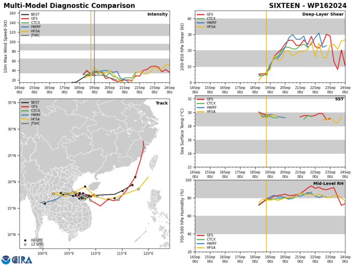
MODEL DISCUSSION: DETERMINISTIC MODEL GUIDANCE REMAINS IN FAIR AGREEMENT IN REGARDS TO BOTH TRACK AND SPEED, UNTIL THE FORECASTED DISSIPATION BY TAU 36, WITH ONE CAVEAT - MOST RECENT GUIDANCE SHIFTED THE LANDFALL LOCATION SLIGHTLY SOUTH, CLOSER TO DA NANG. JTWC FORECAST REFLECTS THAT CHANGE AND IS IN CLOSE PROXIMITY TO THE MULTI-MODEL CONSENSUS ESTIMATE. INTENSITY TRACKERS ARE IN GOOD AGREEMENT, ALL INDICATING DISSIPATION BY TAU 36.
Last Updated - 09/17/24 3 WEEK TROPICAL CYCLONE FORMATION PROBABILITY
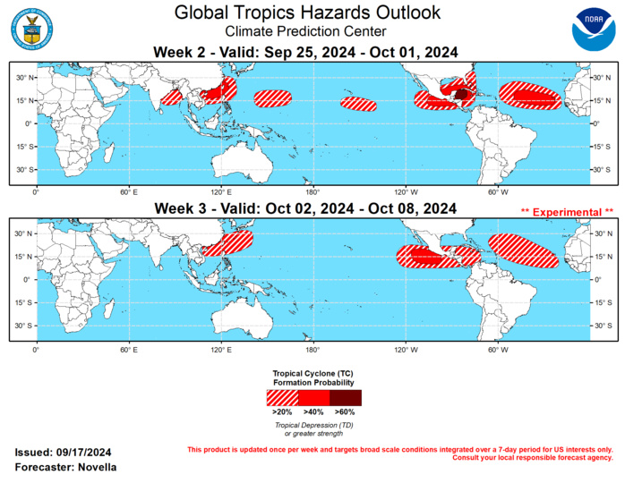
RMM observations show the MJO signal has struggled to fully propagate out of the Maritime Continent since late August. The stalling nature of the MJO signal appears to be related to continued Rossby wave activity in the western Pacific and Maritime Continent which has led to fluctuations of amplitude over this part of tropics in recent weeks. However, the signal has regained amplitude while resuming its eastward propagation more recently, and there is better confidence in the outlook that the MJO will continue to propagate into the Western Pacific and enter the Western Hemisphere during the next several weeks based on improved agreement in the RMM forecasts. While there remains some disagreement in regards to the strength and evolution of the MJO in the upper-level velocity potential forecasts among the models, objective wave filtering suggests that other modes of tropical variability are expected to be important contributors to Tropical Cyclone (TC) potential in the outlook. Specifically, strong Kelvin wave activity moving ahead of the enhanced convective MJO envelope looks to provide favorable conditions for tropical cyclogenesis over the tropical Americas, where continued signs of equatorial Rossby wave activity and a low frequency response aloft is expected to keep the western Pacific active through the end of September. Any reorganizing MJO is also expected to lead to an interruption of an enhanced trade regime over the equatorial Pacific, which may have implications on the favored transition to La Nina conditions later this fall. During the past week, three TCs developed in the global tropics. In the eastern Pacific, TC Ileana formed on 9/12 and peaked at Tropical Storm intensity as it neared Los Cabos, Baja California bringing heavy precipitation to the region. Before dissipating on 9/15, TC Ileana also brought heavy precipitation and high winds to parts of western Mexico. After forming on 9/11 near 16N/28W in the Atlantic, TC Gordon tracked westward across the Main Development Region (MDR). Intensification had been kept at bay due to periods of high shear and dry air entrainment, and as a result, this system dissipated on 9/17. However, as of 1:30 pm EDT today, the NHC shows 40% chances of Gordon redeveloping, as its remnants enter a more favorable environment in the central Atlantic later this week. In the western Pacific, TC Pulasan formed on 9/16 near 18N/140E in the Philippine Sea, and the Joint Typhoon Warning Center (JTWC) expects this system to track northwestward into the East China Sea at Tropical Storm strength. Contrast to the slow moving TC Gordon in the Atlantic, the JTWC notes that constructive interference between a tropical upper tropospheric trough and a subtropical ridge is leading to an uncharacteristically high forward track speed of the system, where it is forecast to make landfall over eastern China in the next day or so. The JTWC is monitoring another tropical disturbance (98W) located over the northern Philippines with high chances of development, but has yet to form at the time of this writing. Tied to the aforementioned Kelvin wave activity traversing the tropical Americas, there is good agreement in the models favoring the development of a band of anomalous lower-level westerlies extending from the south of Mexico into the western Caribbean and lower shear supportive of TC development. Based on good run-to-run continuity in both ensemble and deterministic solutions, and trends in the probabilistic TC genesis tools, 60% chances of TC formation are issued over the western Caribbean, with 40% chances covering both basins, and a broader 20% area extending into western Atlantic where tools also depict elevated signals during week-2. In the MDR, there is good support in the ensembles and probabilistic TC genesis tools favoring one or more easterly waves propagating off West Africa, and 40% chances are issued mainly east of 50W with a broad 20% area highlighted for much of the MDR for week-2. Inhibiting factors may still be periods of high dust and increased shear parts of the MDR, though the ITCZ looks to be in a more favorable position over the African Sahel. In the central Pacific, 20% chances are posted for week-2 approximately between 160W and 140W based on increased support in the ensembles for an area of deepening low pressure and probabilistic guidance. In the western Pacific, there is good agreement between GEFS and ECMWF favoring the persistence of anomalous lower-level westerlies extending from the South China Sea to the south of Japan. With several model solutions showing additional low pressure development, in the region 40% chances for development are issued. Further east, a separate area of 20% chances are also issued for the basin, where there is continued support in the probabilistic tools for development mainly east of the Marianas. Tied to Rossby wave activity predicted over eastern Indian Ocean and some support in the tools, 20% chances are also posted in the Bay of Bengal as this basin climatologically experiences its second mode of TC formations entering October. Should the MJO remain coherent over the Western Hemisphere in October, this historically favors less favorable conditions for TC development in the western Pacific. However, 20% chances are issued over the South China and Philippines Seas during week-3 out of deference to the low frequency response favored in the velocity potential forecasts, as well as climatology. Conversely, a Western Hemisphere MJO would support an elevated potential for development in the Eastern Pacific, and 40% chances are issued to the south of Mexico, with 20% chances extending into parts of the Caribbean. While climatology continues to shift the TC formation potential more into the Caribbean, 20% chances are posted for a broad area in the MDR given modest support in the extended range tools.
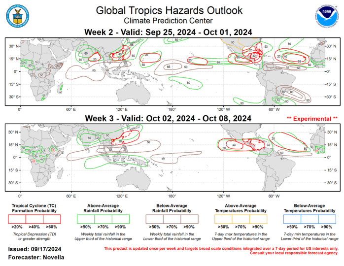
Forecasts for enhanced and suppressed precipitation for weeks 2 and 3 are based on historical composites of Western Pacific and Western Hemisphere MJO events, anticipated TC tracks, and a skill weighted consensus of the CFS, GEFS, ECMWF, and ECCC model systems, with some consideration of ENSO cold phase composites. Tied to amplified 500-hPa ridging favored over much of North America, above-normal temperatures are likely throughout the western and northern CONUS during week-2. For hazardous weather concerns in your area during the next two weeks, please refer to your local NWS office, the Medium Range Hazards Forecast from the Weather Prediction Center (WPC), and the CPC Week-2 Hazards Outlook. Forecasts issued over Africa are made in coordination with the International Desk at CPC.
