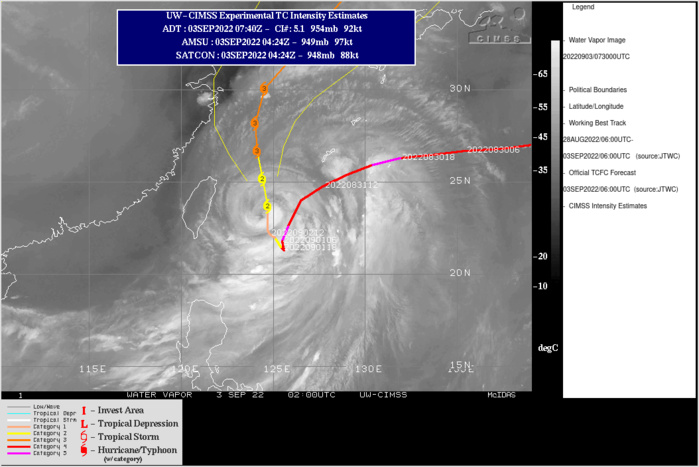
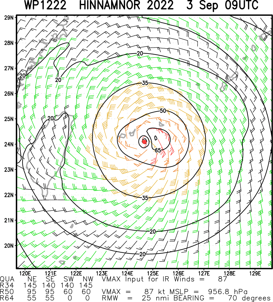
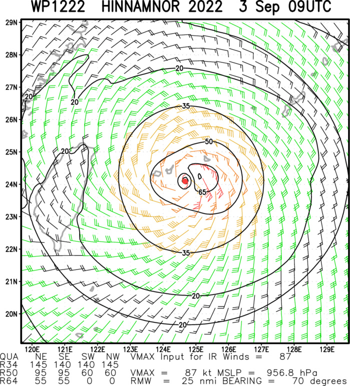
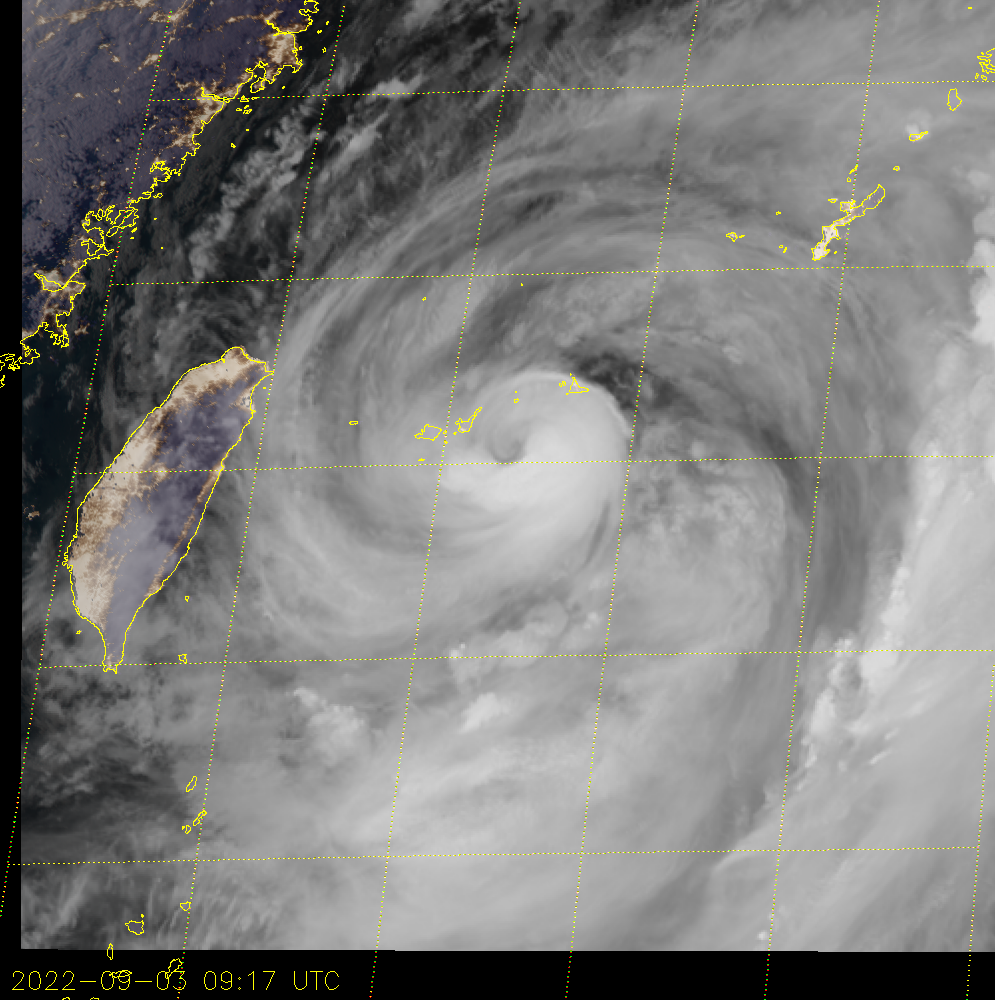
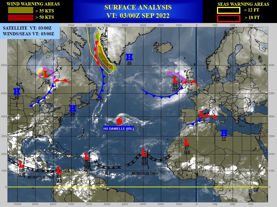
CLICK ON THE IMAGERIES BELOW TO GET THEM ENLARGED
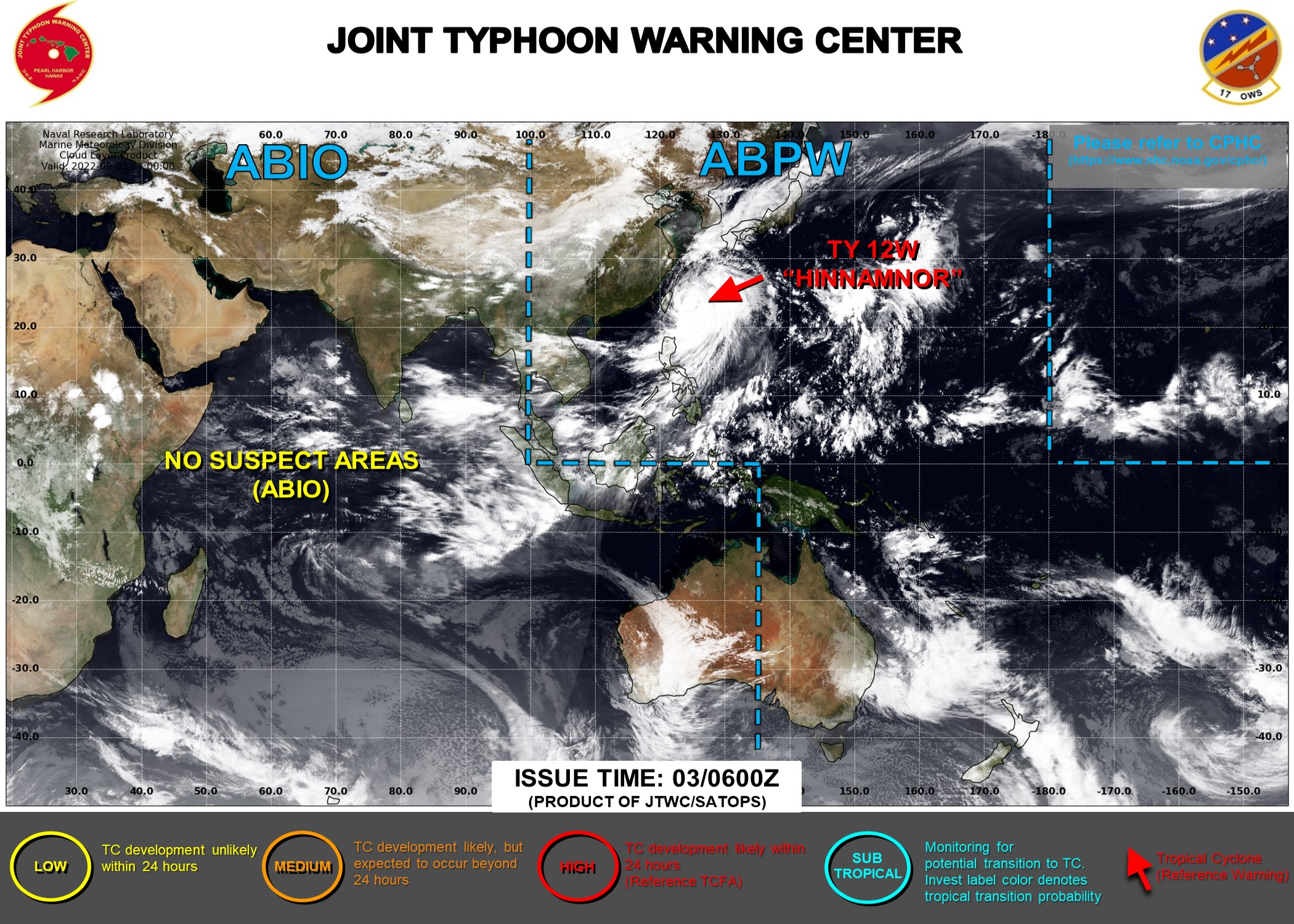
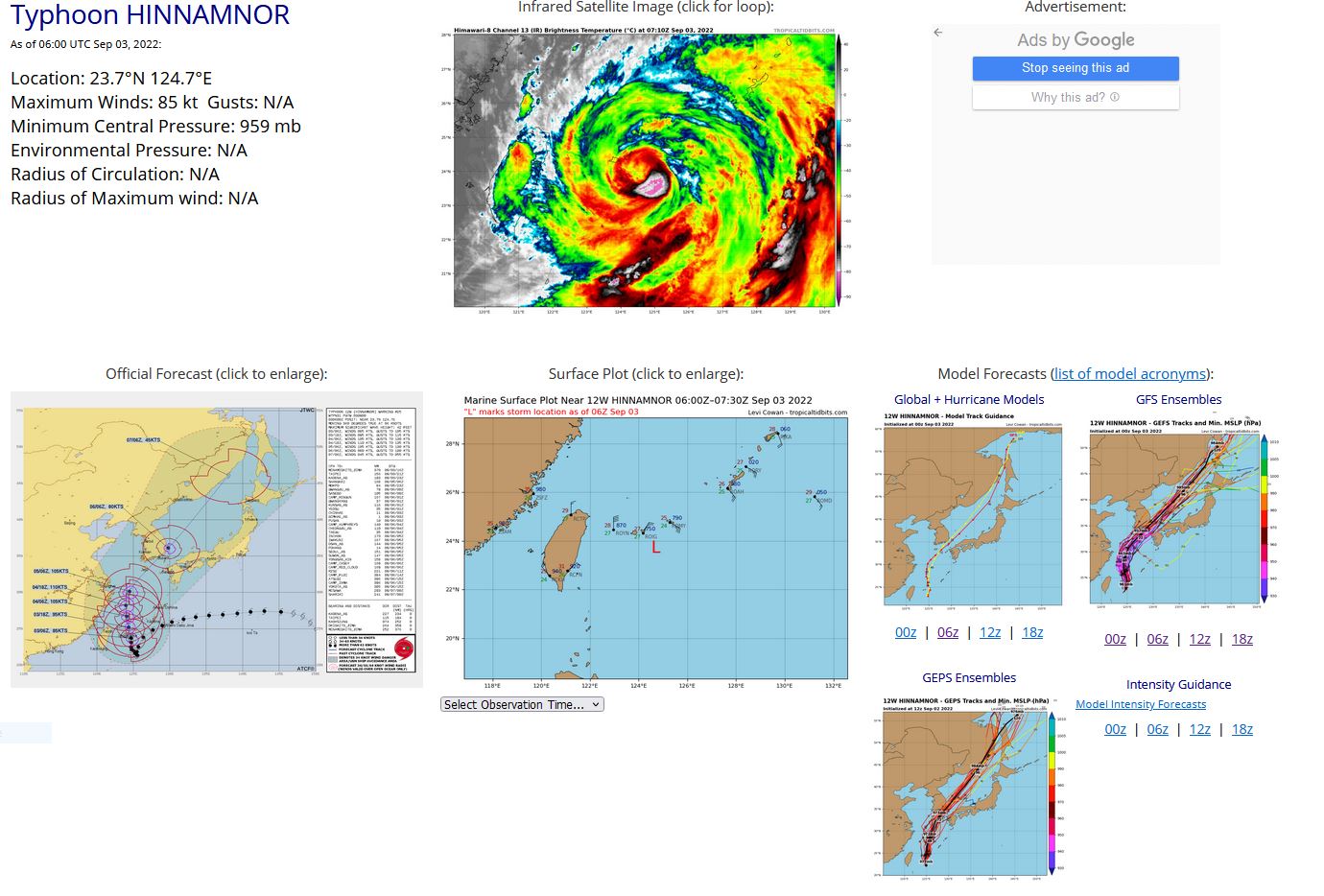
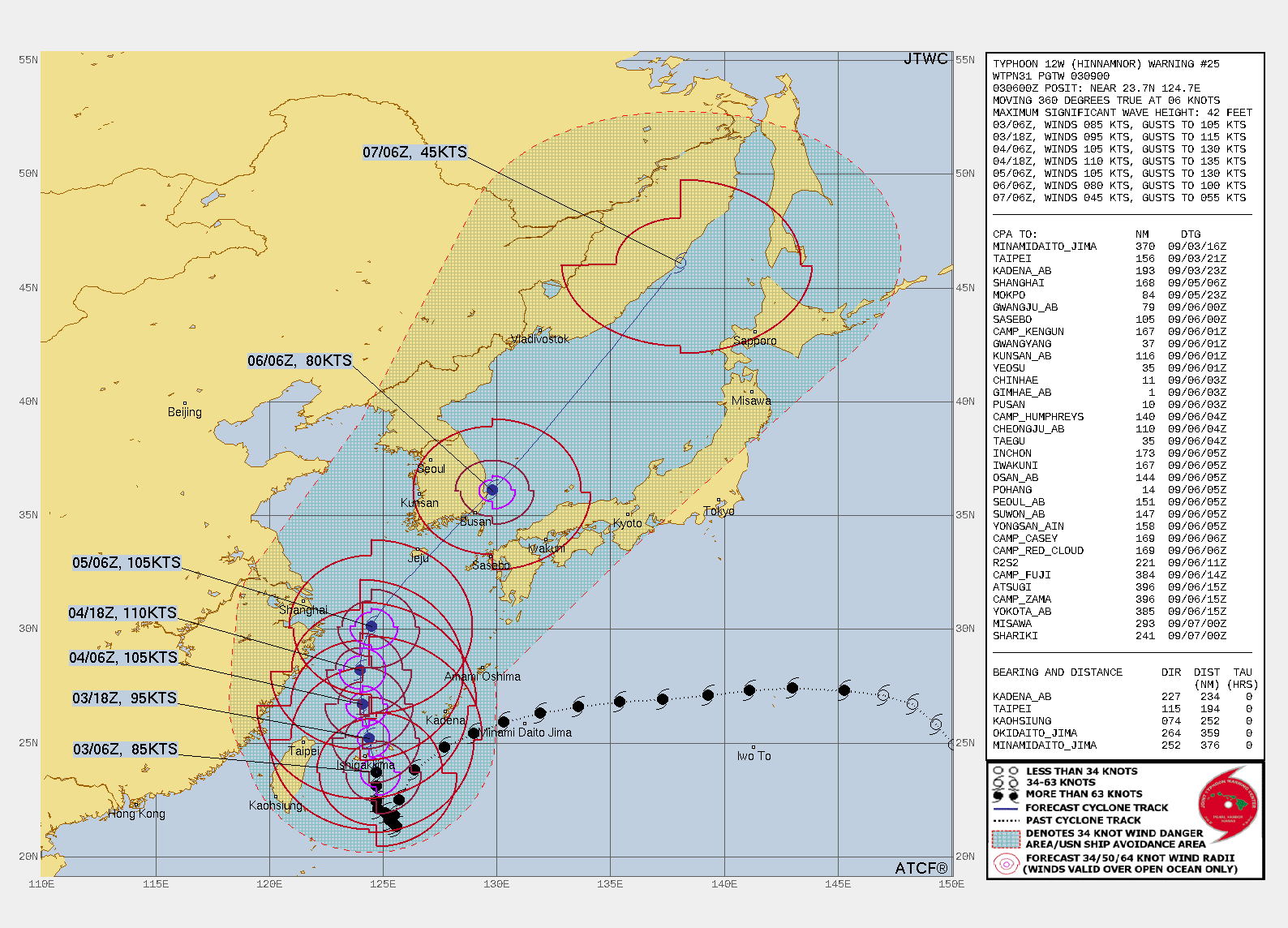
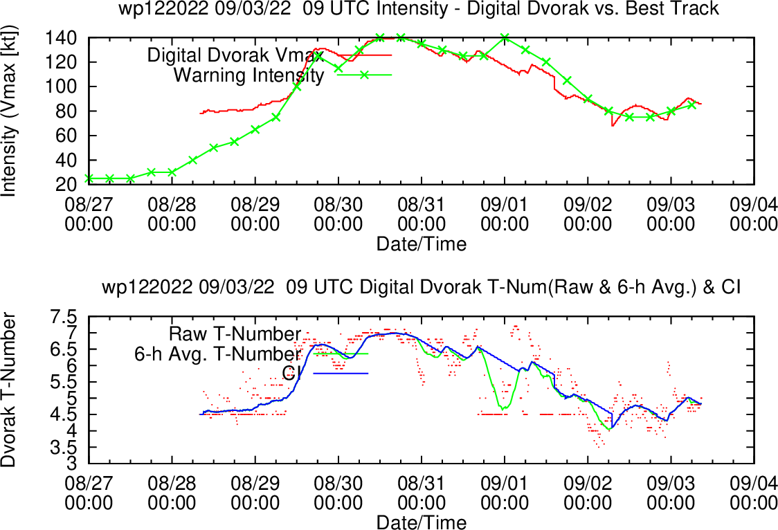
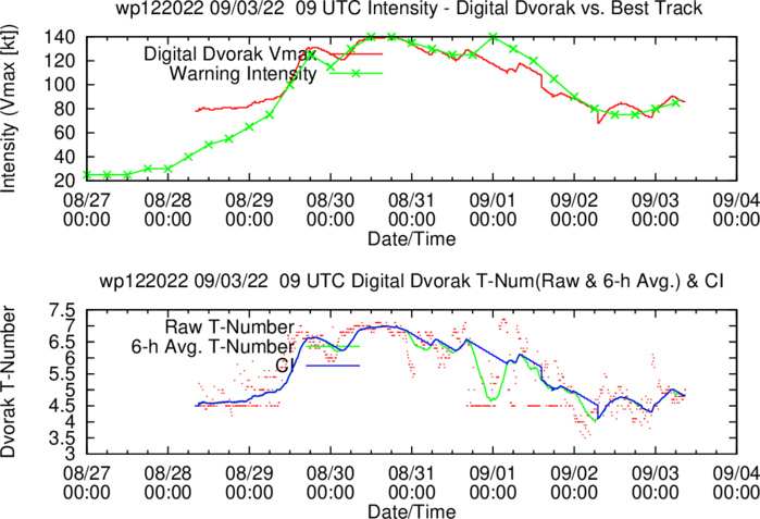
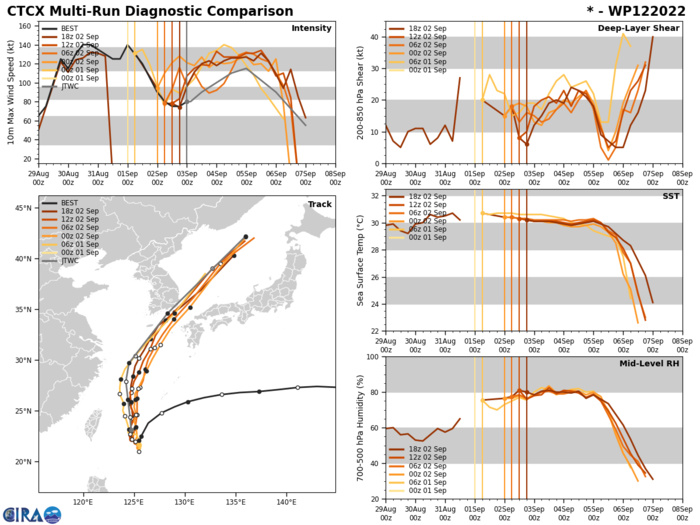
WESTERN NORTH PACIFIC: TY 12W(HINNAMNOR). ESTIMATED LOCATION AND INTENSITY AT 03/06UTC. WARNING 25 ISSUED AT 03/09UTC.
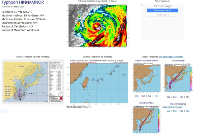
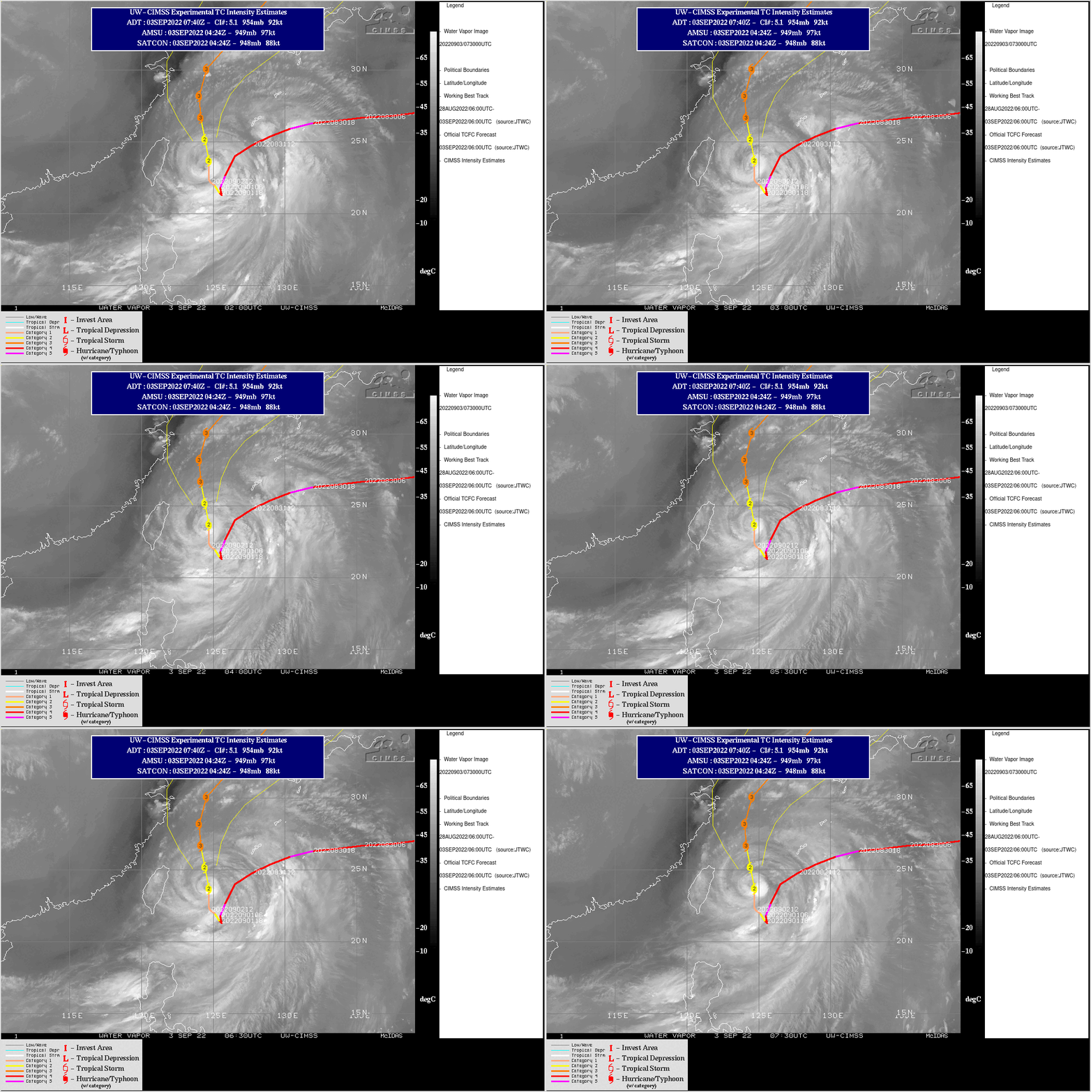
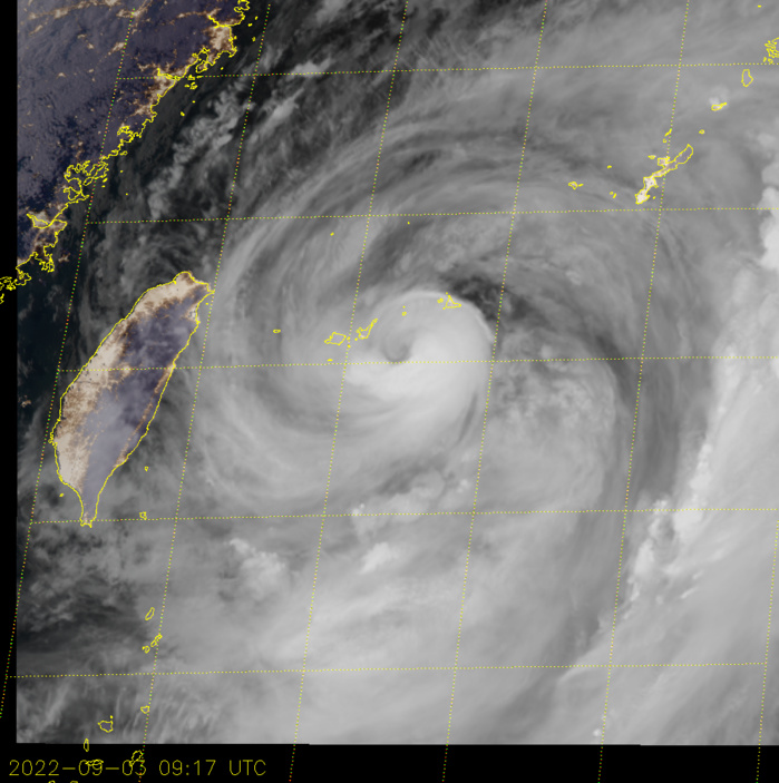
SATELLITE ANALYSIS, INITIAL POSITION AND INTENSITY DISCUSSION: ANIMATED MULTISPECTRAL SATELLITE IMAGERY (MSI) DEPICTS A WELL DEFINED CIRCULATION THAT IS ON THE VERGE OF REDEVELOPING AN EYE. ANIMATED RADAR IMAGERY AND A 030523Z AMSR2 89GHZ COLOR COMPOSITE MICROWAVE IMAGE INDICATE THE SYSTEM IS CONTINUING TO CONSOLIDATE AFTER ITS SLOW NORTHWARD CRAWL OVER THE PAST TWO DAYS. THE AMSR2 IMAGE INDICATING THAT THE SYSTEM IS STILL COMBATING DRY AIR ON ITS NORTHWESTERN PERIPHERY, NEVERTHELESS A NEARLY COMPLETE EYE WALL IS EVIDENT. THE INITIAL POSITION IS PLACED WITH HIGH CONFIDENCE BASED ON MSI, RADAR IMAGERY AND THE AMSR2 MICROWAVE IMAGERY. THE INITIAL INTENSITY OF 85 KTS IS ASSESSED WITH MEDIUM CONFIDENCE BASED ON AGENCY DVORAK ESTIMATES REMAINING LOW 75-77KTS, DUE TO NO CLEAR EYE FEATURE, WHILE CIMSS SATCON AND ADT INDICATE 89-94KTS. THIS REGION OF DVORAK INTENSITY AND METHOD SHIFT FROM WRAPPING TO EYE METHOD IS NOTORIOUSLY TRICKY. FOR EXAMPLE IF THE EYE CLEARS (CLOUD TOPS WARMING) FROM IT CURRENT -43C TO BELOW -41C (A TWO DEGREE DROP) AND THE EYE WALL CONTINUES TO DEVELOP THE DVORAK RETURNS AN EYE METHOD T5.0, SO WE ARE CLOSE.
WP, 12, 2022083112,248N, 1277E,125, 930
WP, 12, 2022083118,238N, 1264E,125, 931
WP, 12, 2022090100,225N, 1257E,140, 915
WP, 12, 2022090106,218N, 1255E,130, 926
WP, 12, 2022090112,213N, 1256E,120, 935
WP, 12, 2022090118,214N, 1255E,105, 947
WP, 12, 2022090200,216N, 1253E, 90, 956
WP, 12, 2022090206,219N, 1251E, 80, 964
WP, 12, 2022090212,221N, 1248E, 75, 966
WP, 12, 2022090218,224N, 1247E, 75, 967
WP, 12, 2022090300,231N, 1247E, 80, 963
WP, 12, 2022090306,237N, 1247E, 85, 959
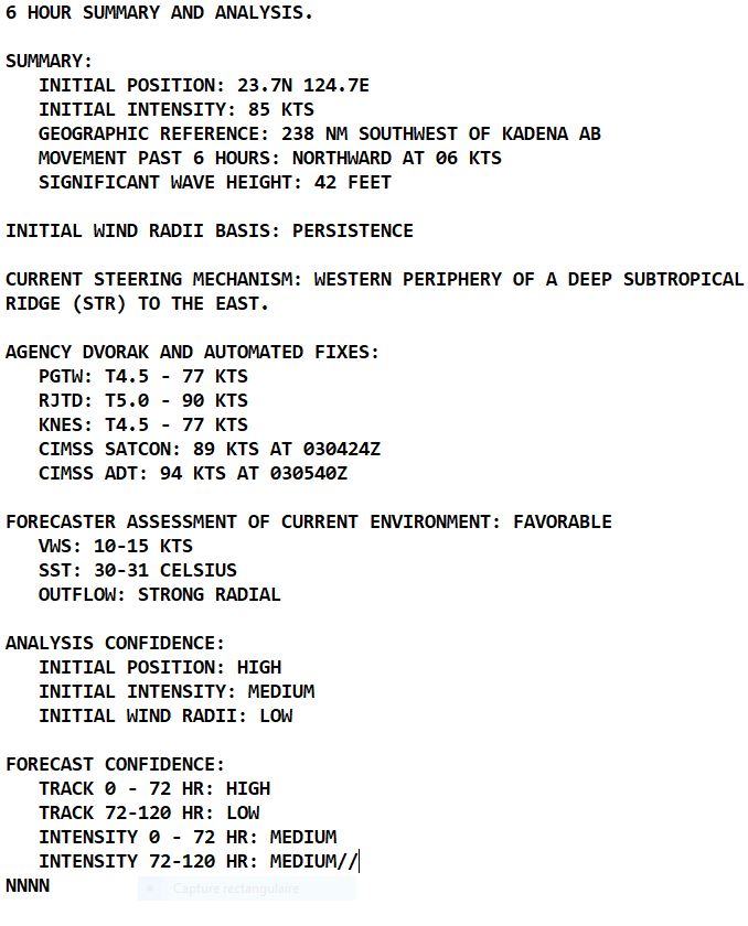
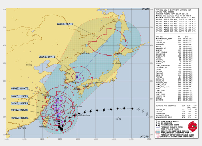
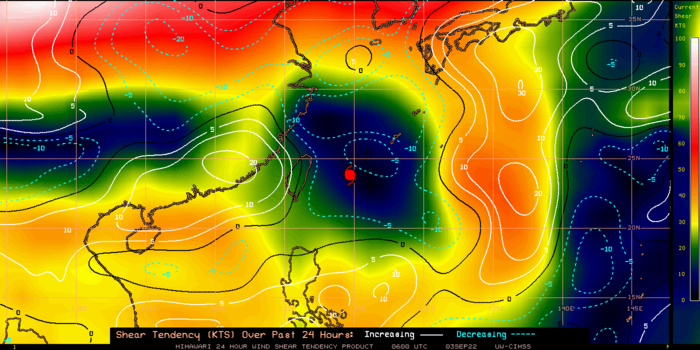
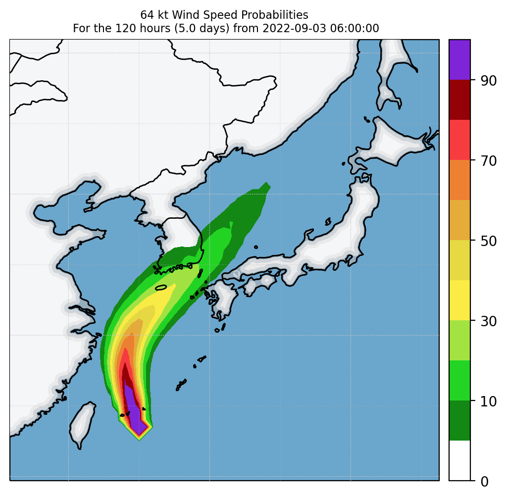
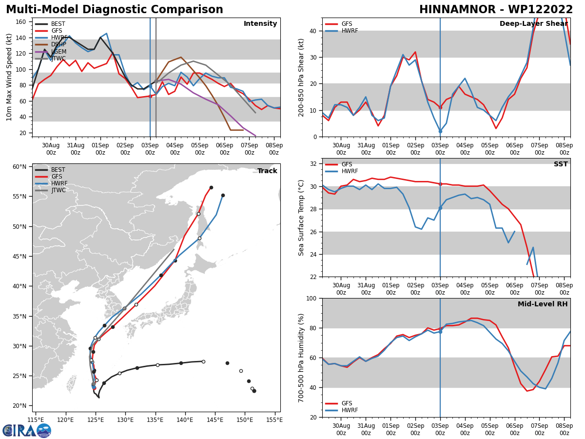
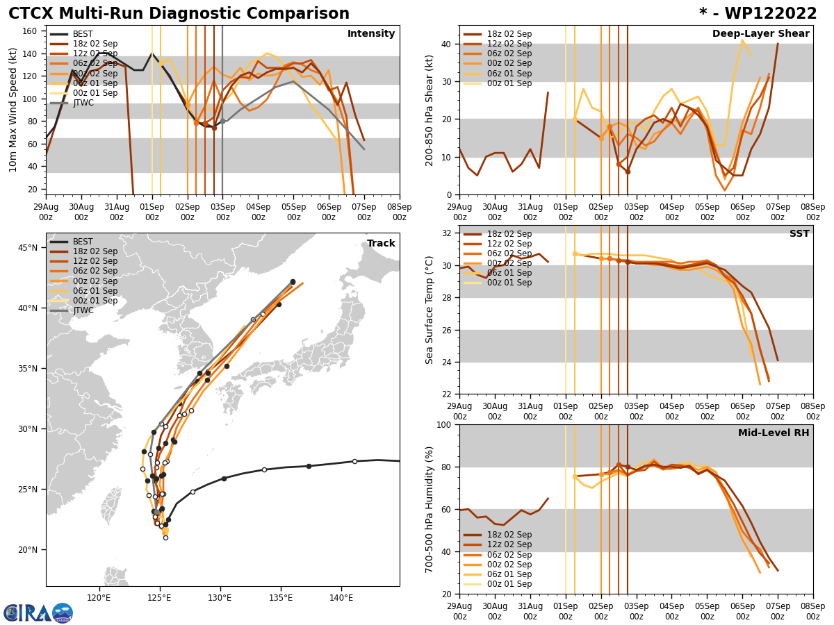
FORECAST REASONING. SIGNIFICANT FORECAST CHANGES: THERE ARE NO SIGNIFICANT CHANGES TO THE FORECAST FROM THE PREVIOUS WARNING. FORECAST DISCUSSION: TY 12W IS CURRENTLY TRACKING NORTH-NORTHWEST UNDER THE STEERING INFLUENCE OF A STR TO THE EAST. AS THE SYSTEM CONTINUES TO TRACK GENERALLY NORTHWARD IT WILL PASS JUST EAST OF ISHIKAGIJIMA BEFORE ENTERING THE EAST CHINA SEA. THE SYSTEM IS BATTLING SUBSIDENCE ALOFT AND INHIBITED OUTFLOW ON ITS WESTERN FLANK DUE TO A DEEP LAYERED STR BRINGING NORTHERLY DRY AIR SOUTHWARD, HOWEVER AS THE SYSTEM PROGRESSES NORTHWARD THIS INTERACTION WILL DECREASE AND INTENSITIES WILL RISE. BY TAU 36, THE SYSTEM WILL REACH ITS PEAK NEAR 110KTS AS IT BRIEFLY TAPS INTO A GOOD POLEWARD OUTFLOW CHANNEL WHICH IS THE HERALD OF ITS IMPEDING EXTRATROPICAL TRANSITION. BY TAU 48, TY 12W WILL BE TRACKING NORTH-NORTHEASTWARD AS ITS STEERING RIDGE REORIENTS DUE TO A STRONG MID-LATITUDE TROUGH APPROACHING FROM THE WEST, THIS INTERACTION WILL ALSO GREATLY INCREASE TRACK SPEEDS. AS THIS TROUGH DIGS DOWN OVER THE KOREAN PENINSULA, 12W WILL EXPERIENCE DRAMATICALLY MORE SHEAR AND WILL BEGIN TO INTERACT WITH THE PENINSULA ITSELF FURTHER WEAKENING THE SYSTEM. AS 12W CROSSES SOUTHERN COAST OF KOREA JUST BEFORE TAU 72, IT INTERACTS WITH AND INCORPORATES INTO THE MID-LATITUDE WESTERLY FLOW ALOFT AND BEGIN EXTRA-TROPICAL TRANSITION. BY TAU 96 THE SYSTEM WILL COMPLETE EXTRATROPICAL TRANSITION IN THE NORTHERN SEA OF JAPAN.
CLICK ON THE IMAGERY BELOW TO GET IT ANIMATED
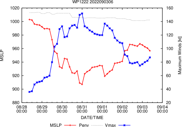
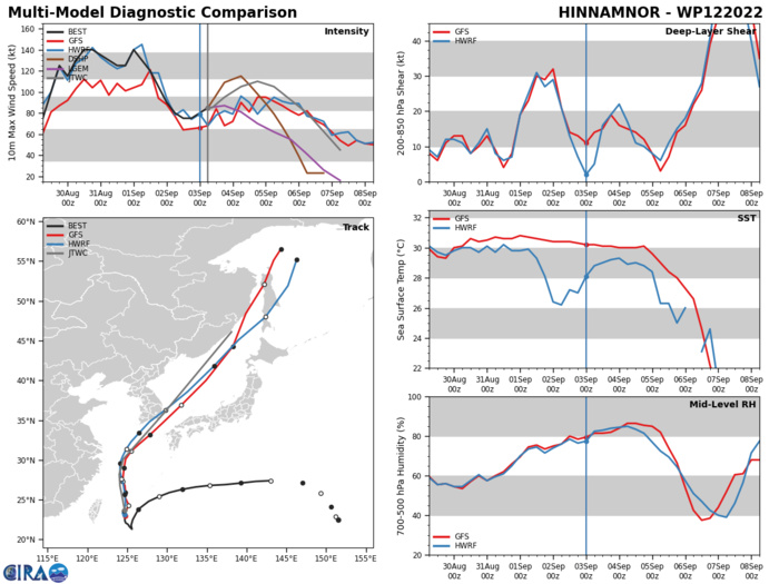
MODEL DISCUSSION: WITH THE EXCEPTION OF COAMPS-TC, NUMERICAL MODELS ARE IN TIGHT AGREEMENT THAT 12W WILL CONTINUE ITS GENERALLY NORTHWARD TREND BEFORE A NORTHEASTERLY RECURVE NEAR TAU 48 AND A FINAL RAPID ACCELERATION TOWARD THE NORTHEASTERN SEA OF JAPAN. AFTER PASSING THE KOREAN PENINSULA, THERE IS A NOTABLE CROSS TRACK SPREADING THROUGH THE FORECAST PERIOD. FOR THESE REASONS THE CURRENT JTWC TRACK FORECAST IS PLACED WITH HIGH CONFIDENCE AND THE EXTENDED TRACK FORECAST IS PLACED WITH LOW CONFIDENCE. RELIABLE MODEL INTENSITY GUIDANCE IS IN FAIR AGREEMENT WITH A BULK OF THE MODELS SHOWING A GENERAL INTENSIFICATION TREND THROUGH 36 WHILE HWRF AND DECAY-SHIPS (NAVGEM) INDICATE STAGNATION AND DISSIPATION PAST TAU 12. THIS DISCREPANCY IN INTENSIFICATION TREND IS WHY THE JTWC FORECAST INTENSITY IS PLACED WITH MEDIUM CONFIDENCE.
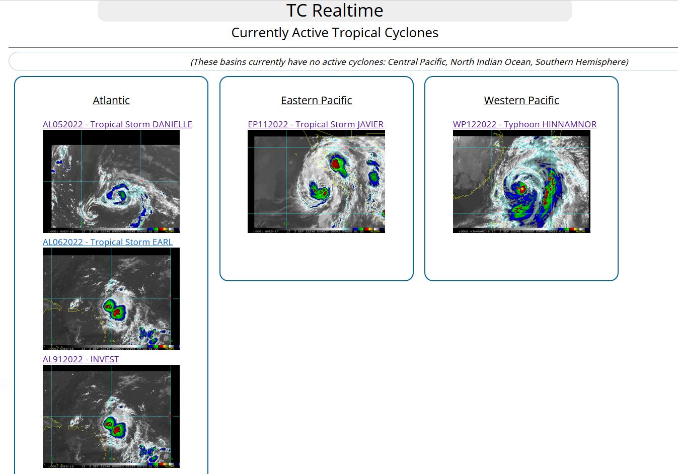
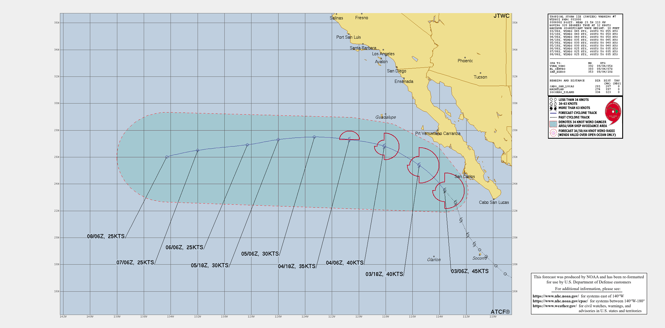
EASTERN NORTH PACIFIC: TS 11E(JAVIER). WARNING 7 ISSUED AT 03/10UTC. NHC COMMENTS.
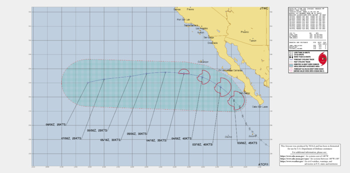
WTPZ41 KNHC 030852 TCDEP1 Tropical Storm Javier Discussion Number 7 NWS National Hurricane Center Miami FL EP112022 300 AM MDT Sat Sep 03 2022 This morning's satellite presentation consists of a recent deep convective burst with -78C cloud tops just to the west of the surface circulation center. A 0116 UTC SSMI/S microwave image showed a primary curved band wrapping around 65 percent of the cyclone's surface center. Based on a compromise of the latest subjective Dvorak estimates from TAFB and SAB, a 0428 UTC SATCON analysis of 49 kt, and a recent ASCAT-B scatterometer pass revealing a few peak-wind retrievals of 39 kt (undersampling likely), the initial intensity is held at 45 kt for this advisory. There's a small window of opportunity that Javier could strengthen slightly today before it moves over a gradient of progressively cooler waters of less than 24C this evening. This negatively contributing oceanic parameter, along with an increasingly stable surrounding environment should cause Javier to become a post-tropical cyclone Sunday, and a remnant low-pressure system by early next week. Javier's initial motion is estimated to be northwestward, or 320/13 kt. This general motion should continue through today in response to the mid-level steering flow produced by a mid-tropospheric ridge anchored over the southwestern U.S. and northern Mexico. By early Sunday, the global models are in good agreement that this ridge should build westward and influence Javier to slowly turn toward the west-northwest to west while the cyclone weakens. The NHC forecast follows suit and lies close to the TVCE and NOAA HFIP HCCA consensus aids. Javier's wind radii have been adjusted for this advisory using a fortuitous 0430 UTC METOP-B ASCAT overpass. Although the NHC forecast wind radii do not explicitly reach the coast of Mexico, any additional eastward deviation from the official track forecast could result in tropical-storm-force winds reaching portions of Baja California Sur where a Tropical Storm Watch is in effect. KEY MESSAGES: 1. Although the center is expected to stay offshore, heavy rainfall from Tropical Storm Javier could lead to localized flash flooding in Baja California Sur. 2. Tropical storm conditions are possible across portions of Baja California Sur through today. A Tropical Storm Watch is in effect. FORECAST POSITIONS AND MAX WINDS INIT 03/0900Z 24.0N 114.1W 45 KT 50 MPH 12H 03/1800Z 25.4N 115.5W 40 KT 45 MPH 24H 04/0600Z 26.8N 118.1W 40 KT 45 MPH 36H 04/1800Z 27.3N 120.7W 35 KT 40 MPH...POST-TROPICAL 48H 05/0600Z 27.5N 123.3W 30 KT 35 MPH...POST-TROP/REMNT LOW 60H 05/1800Z 27.3N 126.0W 30 KT 35 MPH...POST-TROP/REMNT LOW 72H 06/0600Z 26.9N 128.3W 25 KT 30 MPH...POST-TROP/REMNT LOW 96H 07/0600Z 26.5N 132.0W 25 KT 30 MPH...POST-TROP/REMNT LOW 120H 08/0600Z 26.0N 134.3W 25 KT 30 MPH...POST-TROP/REMNT LOW $$ Forecaster Roberts
EP, 11, 2022090200,191N, 1110W, 30,1003
EP, 11, 2022090206,195N, 1114W, 35,1000
EP, 11, 2022090212,202N, 1119W, 40,1000
EP, 11, 2022090218,213N, 1124W, 40,1000
EP, 11, 2022090300,226N, 1128W, 45, 999
EP, 11, 2022090306,235N, 1136W, 45, 999
EP, 11, 2022090206,195N, 1114W, 35,1000
EP, 11, 2022090212,202N, 1119W, 40,1000
EP, 11, 2022090218,213N, 1124W, 40,1000
EP, 11, 2022090300,226N, 1128W, 45, 999
EP, 11, 2022090306,235N, 1136W, 45, 999
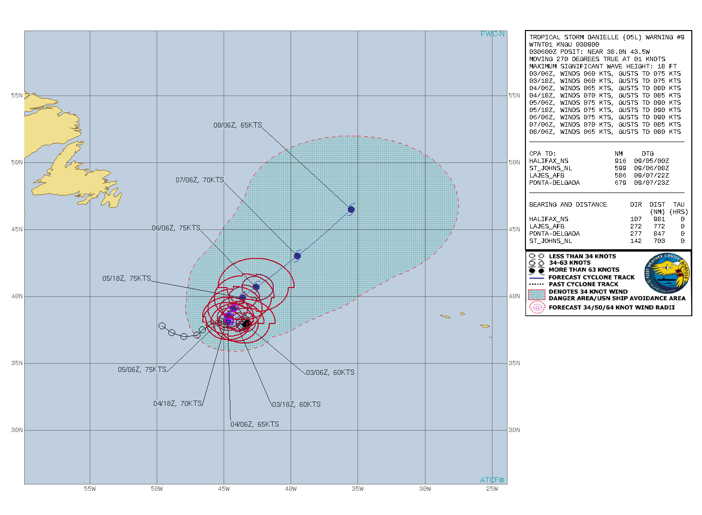
NORTH ATLANTIC: TS 05L(DANIELLE).WARNING 9 ISSUED AT 03/09UTC. NHC COMMENTS.
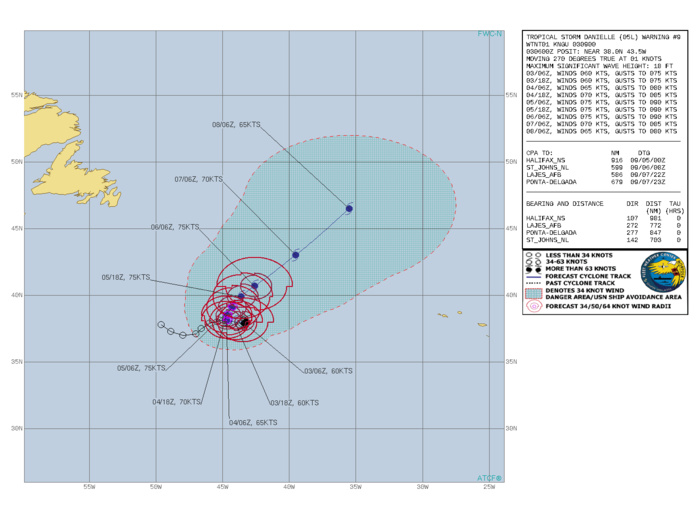
000 WTNT45 KNHC 030852 TCDAT5 Tropical Storm Danielle Discussion Number 9 NWS National Hurricane Center Miami FL AL052022 900 AM GMT Sat Sep 03 2022 Convection associated with Danielle has continued to decrease this morning, with a corresponding decrease in satellite intensity estimates. Based on this decrease, it is estimated that Danielle has weakened to a tropical storm with an initial intensity of 60 kt. While it is not known why the storm has weakened, one possibility is that the slow motion has allowed the cyclone to upwell cold water underneath it. Danielle is essentially stationary with a 12-h motion of 270/1 kt. The cyclone is still caught south of a blocking high over the North Atlantic. This pattern is expected to hold firm for a couple of days, with the system forecast to drift westward and then drift northward. After 48-60 h, the block will weaken and allow the southern edge of the mid-latitude westerlies to steer Danielle generally northeastward at a faster forward speed. There are no significant changes to the forecast track for the first 48-60 h. After that, the forecast has been nudged eastward due to a shift in the guidance envelope. The intensity guidance is still calling for Danielle to strengthen for 72 h or so. Given the possibility of upwelling and the forecast continued slow motion, the guidance might be a bit optimistic on that. The new intensity forecast calls for little change in strength for 12 h or so, followed by slow strengthening on the premise that the storm will move over somewhat warmer water. After 72 h, the storm is likely to interact with an upper-level trough, which could help maintain the intensity even as Danielle moves toward much colder water in the North Atlantic. This trough will also start extratropical transition, although this will likely not be complete by 120 h. FORECAST POSITIONS AND MAX WINDS INIT 03/0900Z 38.0N 43.8W 60 KT 70 MPH 12H 03/1800Z 38.0N 44.1W 60 KT 70 MPH 24H 04/0600Z 38.1N 44.7W 65 KT 75 MPH 36H 04/1800Z 38.5N 44.7W 70 KT 80 MPH 48H 05/0600Z 39.1N 44.3W 75 KT 85 MPH 60H 05/1800Z 39.9N 43.6W 75 KT 85 MPH 72H 06/0600Z 40.7N 42.6W 75 KT 85 MPH 96H 07/0600Z 43.0N 39.5W 70 KT 80 MPH 120H 08/0600Z 46.5N 35.5W 65 KT 75 MPH $$ Forecaster Beven
AL, 05, 2022090106,381N, 452W, 30
AL, 05, 2022090112,381N, 448W, 35
AL, 05, 2022090118,381N, 445W, 50
AL, 05, 2022090200,380N, 441W, 55
AL, 05, 2022090206,379N, 436W, 60
AL, 05, 2022090212,380N, 432W, 65
AL, 05, 2022090218,379N, 435W, 65
AL, 05, 2022090300,379N, 434W, 65
AL, 05, 2022090306,380N, 435W, 60
AL, 05, 2022090112,381N, 448W, 35
AL, 05, 2022090118,381N, 445W, 50
AL, 05, 2022090200,380N, 441W, 55
AL, 05, 2022090206,379N, 436W, 60
AL, 05, 2022090212,380N, 432W, 65
AL, 05, 2022090218,379N, 435W, 65
AL, 05, 2022090300,379N, 434W, 65
AL, 05, 2022090306,380N, 435W, 60
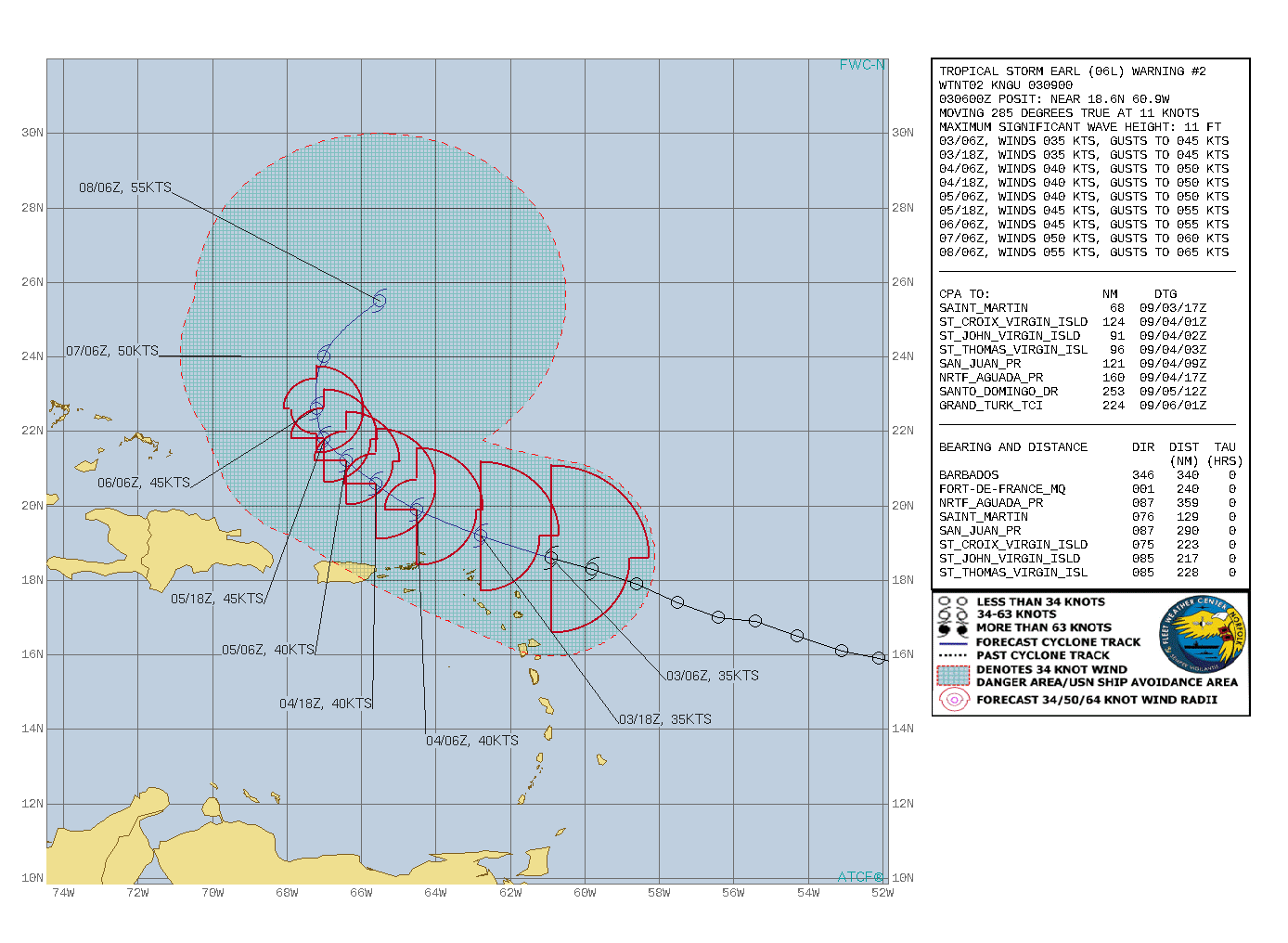
NORTH ATLANTIC: TS 06L(EARL). WARNING 2 ISSUED AT 03/09UTC. NHC COMMENTS.
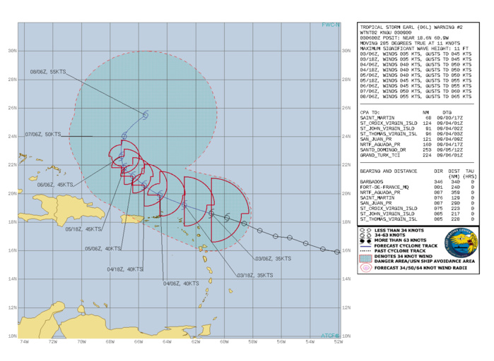
000 WTNT41 KNHC 030842 TCDAT1 Tropical Storm Earl Discussion Number 2 NWS National Hurricane Center Miami FL AL062022 500 AM AST Sat Sep 03 2022 Satellite imagery and radar data from Guadeloupe show that Earl remains a sheared tropical cyclone, with the low-level center located to the west of the main convective mass. Various satellite intensity estimates are in the 25-45 kt range and have changed little since the last advisory. Based on this, the initial intensity remains 35 kt. A NOAA Hurricane Hunter aircraft will investigate Earl starting near 1000 UTC. The initial motion is 285/11. The track guidance remains in good agreement that Earl should move west-northwestward and northwestward with a decrease in forward speed for the next couple of days as it is steered by the subtropical ridge. There is little change in this part of the forecast track from the previous advisory. After that time, a slower motion toward the north and eventually north-northeast is expected as a mid- to upper-level trough develops over the Atlantic to the west and north of Earl. The guidance envelope for the latter part of the forecast track has shifted eastward, and while the new forecast track is also nudged eastward it is west of the consensus models from 60-120 h. Earl is feeling the effects of moderate westerly shear, and current indications are this will continue for the next 48 h or so. Thus, the intensity forecast calls for modest strengthening during this time. The intensity forecast becomes more uncertain as Earl turns northward. While some shear is likely to continue, the dynamical models are in good agreement that the cyclone will strengthen, possibly due to a favorable interaction to the aforementioned upper-level trough. However, there is poor agreement between the models in the details of this interaction. Given that, the intensity forecast from 72-120 h will show a little more strengthening than the previous forecast. However, the forecast intensities are on the low side of the guidance envelope. Tropical-storm-force winds are forecast to remain on the northern and eastern side of the circulation, and as a result, are not expected to move across the northern Leeward Islands, the Virgin Islands, or Puerto Rico. However, any southward shift of Earl's center would increase the risk of tropical-storm-force winds in those areas. KEY MESSAGES: 1. Tropical Storm Earl is forecast to pass near or just to the north of the northern Leeward Islands, the Virgin Islands, and Puerto Rico over the weekend. Gusty winds, especially in squalls, area possible on those islands over the next day or two. 2. Heavy rainfall from Earl is expected to lead to limited flash, urban, and small stream flooding impacts over the Leeward Islands, U.S. and British Virgin Islands, and Puerto Rico this weekend. Rapid rises on rivers are possible in Puerto Rico. FORECAST POSITIONS AND MAX WINDS INIT 03/0900Z 18.7N 61.4W 35 KT 40 MPH 12H 03/1800Z 19.2N 62.8W 35 KT 40 MPH 24H 04/0600Z 19.9N 64.5W 40 KT 45 MPH 36H 04/1800Z 20.6N 65.6W 40 KT 45 MPH 48H 05/0600Z 21.2N 66.4W 40 KT 45 MPH 60H 05/1800Z 21.8N 67.0W 45 KT 50 MPH 72H 06/0600Z 22.6N 67.2W 45 KT 50 MPH 96H 07/0600Z 24.0N 67.0W 50 KT 60 MPH 120H 08/0600Z 25.5N 65.5W 55 KT 65 MPH $$ Forecaster Beven
AL, 06, 2022090300,186N, 609W, 35
AL, 06, 2022090306,183N, 598W, 35
AL, 06, 2022090306,183N, 598W, 35
